Maps of England

England.
1 : 1774080 Mitchell, Samuel Augustus
England
1 : 1380000 Anglie Weiland, Karl Ferdinand Maedel, Carl Jos. Geograph. Institut
England
1 : 1380000 Anglie Weiland, Karl Ferdinand Maedel, Carl Jos. Geograph. Institut
England, Wales, Scotland.
1 : 1020000 Faden, William, 1750?-1836
England, Wales.
1 : 1800000 Flemming, Carl

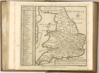
A travelling mapp of England containing the principall roads which are laid down with the comensurated distances
1 : 1330000 [...] by Philip Lea London : sold by Philip Lea Globe maker at the Atlas and Hercules in Cheap side neer Fryday Street end
Smith's new map of England and Wales with parts of Scotland : including the turnpike, and principal crossroads ... / engraved by Edw[ar]d Jones & Benj[ami]n Smith
1 : 1275000 Jones, Edward (fl. 1806); Smith, Benjamin London : C. Smith
England and Wales.
1 : 2700000 Lucas, Fielding Jr.
Anglie a Wales

England and Wales.
1 : 1725000 Teesdale, Henry

Geological map of England and Wales / publ. under the superintendence of the Society for the Diffusion of Useful Knowledge ; arr. by Roderick Impey Murchison ; S.P. Woodward del.; cold. by T. Malby; J. & C. Walker sculpt
1 : 1780000 Annotatie: Oorspr. uitg.: Strand : Chapman and Hall, 1843; Annotatie geografische gegevens: Met aanvullingen tot 1847 Roderick Impey Murchison 1792-1871; S.P. Woodward; T. Malby; Society for the Diffusion of Useful Knowledge London : Knight
Composite: (Cary's England, Wales, and Scotland).
1 : 360000 Cary, John, ca. 1754-1835
Magnae Britanniae pars meridionalis in qua regnum Angliae tam in septem antiqua Anglo-Saxonum regna quam in omnes hodiernas regiones accurate divisum hic ostenditur quam tabula ab archetypo Vischeriano desumptam
1 : 1300000 Anglie Homann, Johann Baptist Ioh. Bapt. Homan[n]
County Map Of England, And Wales.
1 : 2400000 Mitchell, Samuel Augustus
Britanniae sive Angliae regnum
1 : 1300000 Anglie Lotter, Tobias Conrad sumtibus Tob. Conradi Lotter
A new mapp of the kingdome of England
Anglie Overton, John by Nicolas Visscher
Kingdoms of the Anglo-Saxons.
Lavoisne, M.
England.
1 : 1090000 Arrowsmith, John
England.
1 : 1760000 Tanner, Henry S.
England.
1 : 1760000 Tanner, Henry S.
England And Wales.
1 : 2850000 Finley, Anthony
Ordnance survey map of XVII century England
1 : 1000000 Anglie Ordnance Survey Office
Angleterre.
1 : 1250000 Vivien St Martin, L.
[Recto], uit: England and Wales
1 : 1108000 [London] : Philip [etc.]
61-62. England and Wales. The World Atlas.
1 : 1250000 USSR (Union of Soviet Socialist Republics).
Geological map England, Wales.
1 : 1774080 Letts, Son & Co.