Maps of North Atlantic Ocean


Barbary and Bildulgerid ; A map of Zaara, Negroe-land, Guinea, &c. (Inset: The Isles of C, Verd)
from A system of geography, or, A new & accurate description of the earth in all its empires, kingdoms and states : illustrated with history and topography, and maps of every country : fairly engraven on copper, according to the latest discoveries and corrections / by Herman Moll.
A compleat chart of the coast of Asia and America with the great South Sea / R.W. Seale del. et sculp.
from John H. Levine Collection R.W. Seale,
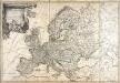
[122][125][Totius Europae littora ... pascaert ... Europa, uit: Atlas sive Descriptio terrarum orbis
Annotatie: Gedigitaliseerde versie. Amsterdam. Heiloo : Picturae (vervaardiger), 2015. tiff-bestand. Gedigitaliseerd: 07-01-2015; Origineel: Universiteitsbibliotheek Vrije Universiteit (XL.05127.-) ; Netherlands; Titelpagina ontbreekt Wit, Frederik de Amsterdam : Frederick de Wit
Itinéraires suivis par les voyages Français et autres qui ont pénétré dans le Sahara
1 : 20000000 Erhard Bros. (Firm) Imp-Janson
Specialia vom Vulkan Gurtel des Atlantischen Oceans.
Berghaus, Heinrich
Itinéraires du yacht "Princesse Alice" dans l'Océan atlantique nord, dans la Méditerranée et dans l'Océan glacial arctique, de 1891 a 1899
Atlantský oceán Tollemer, A. Imprimerie Vieillemard
Übersichts Karte zu den Reisen in Europa, Asien und Afrika
1 : 11700000 Afrika severovýchodní Verlag der E. Schweizerbrat'schen Buchhandlung
Pascaarte van alle de Zécusten van Europa
Blaeu, Willem Janszoon
Mittel- und Nord-Africa, westl. Theil

Übersichts Karte zu den Reisen in Europa, Asien und Afrika unternommen von dem k. k. oesterreich. Bergrathe Joseph Russegger in den Jahren von 1835 bis 1841
1 : 11400000 Afrika E. Schweizerbart'schen Buchhandlung
Übersichts Karte zu den Reisen in Europa, Asien und Afrika unternommen von dem k. k. oesterreich. Bergrathe Joseph Russegger in den Jahren von 1835 bis 1841
1 : 11400000 Afrika

EVROPA
recens descripta | à | Guilielmo Blaeuw. [Amsterdam : Joan Blaeu]
Noroeste de Africa
1 mapa. Datat al s. XIX. Gras y compañia, editores. Madrid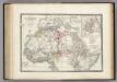
Afrique partie Nord.
1 : 16000000 Levasseur, E.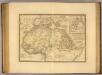
Afrique, septentrionale.
1 : 16000000 Picquet, C.
Erdprofil

Carte demonstrative des determinations astronomiques de latitude et d'azimuth
1 : 10000000 Institut topographique militaire
Europa Exactissime Descripta [Karte], in: Gerardi Mercatoris et I. Hondii Newer Atlas, oder, Grosses Weltbuch, Bd. 1, S. 30.
1 Karte aus Atlas Mercator, Gerhard und Hondius, Jodocus Jansson, Jan
Europe : laid down from the observations of the Royal Academy of Sciences & compared with the maps of Sanson, Nolin, Du Fer, De l'Isle, Moll & other modern geographers ... / [John Bowles] ; engrav'd by Emanuel Bowen
1 : 4500000 Annotatie: Met tabel van Europese lengtematen; Met informatie over de verschillende Europese staten Bowles, John; Bowen, Emanuel London : printed for John Bowles
Europa nach seinen kirchlichen Verhältnissen im Mittelalter
1 : 15000000 Europa Kirchengeschichte

Europa Exactissime Descripta [Karte], in: Novus atlas absolutissimus, Bd. 1, S. 25.
1 Karte aus Atlas Janssonius Offizin
Mittel- und Nord-Africa und Arabien. Westliches Blatt
Stieler's Hand-Atlas Stieler, Adolf bei Justus Perthes
Nova et accurate divisa in regna et regiones praecipuas Europae descriptio
1 : 10000000 per F. de Witt Amstelodami [Amsterdam] : ex officina I. Cóvens et C. Mortier
Europa
1 Karte : Kupferdruck ; 45 x 53 cm Götze im Verlage des Geograph: Instituts
Europa
1 Karte : Kupferdruck ; 45 x 55 cm Götze im Verlage des Geograph. Instituts
Europa
1 Karte : Kupferdruck ; 46 x 54 cm Götze im Verlage des Geograph. Instituts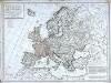
Carte politique de l'Europe
1 Karte : Kupferdruck ; 50 x 68 cm Poirson; Jean; Brion de la Tour chez Jean rue Jean de Beauvais no. 10
Carte politique hydrographique [et] routiere de l'Europe
1 Karte : Kupferdruck ; 48 x 54 cm Champion; Hinrichs chez J. C. Hinrichs libraire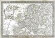
L'Europe
1 Karte : Kupferdruck ; 43 x 66 cm Nolin; Boniselle; Jean chez Jean rue Jean de Beauvais no. 32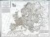
Carte politique de l'Europe
1 Karte : Kupferdruck ; 50 x 68 cm Poirson; Jean; Brion de la Tour chez Jean rue Jean de Beauvais no. 32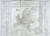
Tableau général de l'Europe
1 Karte : Kupferdruck ; 35 x 44 cm, Bildgrösse: 52 x 73 cm Brion de la Tour; Le Campion; Le Campion chés les Campion freres m.ds d'estampes rue St. Jacques près la f.e S. Severin à la ville de Rouen