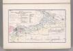
Maps of powiat olkuski

Coal Fields No. 8, Austria. Coal Resources of the World.
1 : 344800 Petrascheck, W.
Karta przeglądowa polskiego zagłębia węglowego
1 : 300000 Polsko Sarjusz-Makowski, Arnold
Ducatus Oswieczensis, Et Zatoriensis, Descriptio. [Karte], in: Theatrum orbis terrarum, S. 375.
1 Karte aus Atlas Ortelius, Abraham Vrients, Jan Baptista
Ducatus Oswieczensis, Et Zatoriensis, Descriptio. [Karte], in: Theatrum orbis terrarum, S. 280.
1 Karte aus Atlas Ortelius, Abraham
DVCATVS | OSWIECZENSIS, | et | ZATORIENSIS.
[Amsterdam : Joan Blaeu]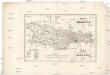
Karta okręgu wolnego miasta Krakowa
1 : 183000 Krakov-oblast (Polsko) Żebrawski, Theofil Friedlein, D. E. nakładem D.E. Friedleina
Karta okręgu wolnego miasta Krakowa
1 : 183000 Krakov-oblast (Polsko) Żebrawski, Theofil Friedlein, D. E. nakładem D.E. Friedleina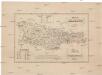
Karta okręgu wolnego miasta Krakowa
1 : 183000 Krakov-oblast (Polsko) Żebrawski, Theofil Friedlein, D. E. nakładem D.E. Friedleina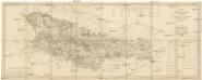
Karte des Gross-Herzogthums Krakau
1 : 114700 Krakov-oblast (Polsko) Liechtenstern, Joseph Marx von Kummersberg, Carl von Julius Wildt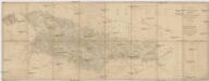
Karte des Gross-Herzogthums Krakau
1 : 114700 Krakov-oblast (Polsko) Liechtenstern, Joseph Marx von Kummersberg, Carl von Julius Wildt
Auschwitz u. Sator
1 : 2000000 Herzogtum Auschwitz
147. Beuthen, uit: Topographische Uebersichtskarte des Deutschen Reiches / herausgegeben v. d. Kartogr. Abt. d. Königl. Preuß. Landesaufnahme
1 : 200000 titelvariant: Topogr. Übersichtskarte des Deutschen Reiches; Annotatie: Titel boven bladen ook: Topogr. Übersichtskarte des Deutschen Reiches; Annotatie geografische gegevens: Op elk blad twee maatstokken: 10 Kilometer = 5,5 cm; 1 geogr. Meile = 3,6 cm; Legenda onder op elk blad Königlich Preußische Landesaufnahme. Kartographische Abtheilung [S.l : Königlich Preußische Landesaufnahme, Kartographische Abtheilung]
Myslowitz und Oswiecim.
from Spezialkarte der osterreichisch-ungarischen Monarchie.
Chrzanow und Krzeszowice.
from Spezialkarte der osterreichisch-ungarischen Monarchie.
Myslowitz und Oświecim
1 : 75000 Bloschitz, R. K. u. k. militär-geographisches Institut
Bielitz und Biala.
from Spezialkarte der osterreichisch-ungarischen Monarchie.
Wadowice.
from Spezialkarte der osterreichisch-ungarischen Monarchie.
Chrzanów und Krzeszowice
1 : 75000 Chrzanów (Polsko) Heimbach K. u. k. Militärgeographisches Institut
Wadowice
1 : 75000 Wadowice (Polsko) Cokorac K. u. k. Militärgeographisches Institut
Bielitz und Biała
1 : 75000 Bielsko-Biała-oblast (Polsko) Bloschitz, R. K. u. k. Militärgeographisches Institut
Bielitz und Biała
1 : 75000 Bielsko-Biała (Polsko : oblast) Otawa K. u. k. militär-geographisches Institut
Bielitz und Biała
1 : 75000 Bielsko-Biała (Polsko : oblast) Otawa K. u. k. Militärgeographisches Institut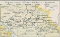
Gegend zwischen Gleiwitz-Beuthen und Myslowitz
1 : 400000 Oberschlesien
Olkusz
1 : 75000 Olkusz (Polsko) K. u. k. Militärgeographisches Institut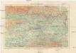
Okolice Krakowa
1 : 150000 Krakov-oblast (Polsko) Gustawicz, Bronisław
Podrobná mapa Markrabství moravského a Vévodství slezkého
1 : 100000 Biała (Polsko : oblast) Srp, Jan Jos. R. Vilímek
Umgebungskarte von Krakau
1 : 75000 Krakov-oblast (Polsko) K. u. k. Militärgeographisches Institut


