Maps of Wales


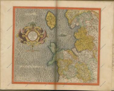
Westmorlandia, Lancastria, Cestria, Caernarvan, Denbigh, Flint, Merionidh, Montogomery, Salopia Cum insulis Mania Et Anglesey. [Karte], in: Gerardi Mercatoris Atlas, sive, Cosmographicae meditationes de fabrica mundi et fabricati figura, S. 115.
1 Karte aus Atlas Mercator, Gerhard Montanus, Petrus
Westmorlandia, Lancastria, Cestria, Caernarvan, Denbigh, Flint, Merionidh, Montogomery, Salopia Cum insulis Mania Et Anglesey. [Karte], in: Atlas, sive, Cosmographicae meditationes de fabrica mundi et fabricati figura, S. 113.
1 Karte aus Atlas Mercator, Gerhard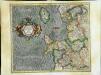
Westmorlandia, Lancastria, Cestria, Caernarvan, Denbigh, Flint, Merionidh, Montgomery, Salopia cum insulis Mania et Anglesey
1 Karte : Kupferdruck ; 34 x 40 cm Mercator; Hondius Henricus Hondius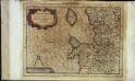
Westmorlandia, Lancastria, Cestria, Caernarvan, Denbigh, Flint, Merionidh, Montgomery, Salopia cum insulis Mania, et Anglesey
1 Karte : Kupferdruck ; 17 x 24 cm Mercator Cloppenburgh
Westmorlandia, Lancastria, Cestria, Caernarvan, Denbigh, Flint, Merionidh, Montgomery, Salopia cum insulis Mania et Anglesey
1 Karte : Kupferdruck ; 34 x 40 cm Mercator; Hondius Jodocus Hondius
Watershed map England, Wales 3.
1 : 760320 Letts, Son & Co.
Principatus Walliae Pars Borealis vulgo North Wales
1 : 390000 Amstelodami : apud Joannem Janssonium
Principatus Walliae Pars Borealis Vulgo North Wales. [Karte], in: Novus atlas absolutissimus, Bd. 8, S. 8.
1 Karte aus Atlas Janssonius Offizin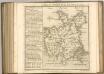

Lancastria Palatinatus Anglis Lancaster et Lancas Shire. [Karte], in: Theatrum orbis terrarum, sive, Atlas novus, Bd. 4, S. 476.
1 Karte aus Atlas Blaeu, Joan Blaeu, Willem Janszoon
Lancastria Palatinatus Anglis Lancaster et Lancas Shire. [Karte], in: Theatrum orbis terrarum, sive, Atlas novus, Bd. 4, S. 476.
1 Karte aus Atlas Blaeu, Joan Blaeu, Willem Janszoon
Lancastria Palatinatus Anglis Lancaster et Lancas shire. [Karte], in: Le théâtre du monde, ou, Nouvel atlas contenant les chartes et descriptions de tous les païs de la terre, Bd. 4, S. 408.
1 Karte aus Atlas Blaeu, Willem Janszoon und Blaeu, Joan Blaeu, Willem Janszoon
England II.
1 : 765000 Society for the Diffusion of Useful Knowledge (Great Britain)
Sheet 2 England, North West, uit: Maps of England & Wales : scale 4 miles to 1 inch / Ordnance Survey
1 : 253440 titelvariant: Maps of England and Wales; Annotatie: Titel op cassette; Met bladoverzicht op de achterzijde van de cassette; Annotatie geografische gegevens: Hoogtelijneninterval 200 ft Ordnance Survey, United Kingdom Southampton : Ordnance Survey Office
LANCASTRIA | PALATINATVS | Anglis | LANCASTER et | Lancas shire.
[Amsterdam : Joan Blaeu]
LANCASTRIAE Comitatus Sheet 28
This map of Lancashire is from the 1583 edition of the Saxton atlas of England and Wales.This atlas was first published as a whole in 1579. It consists of 35 coloured maps depicting the counties of England and Wales. The atlas is of great significance to British cartography as it set a standard of cartographic representation in Britain and the maps remained the basis for English county mapping, with few exceptions, until after 1750. During the reign of Elizabeth I map use became more common, with many government matters referring to increasingly accurate maps with consistent scales and symbols, made possible by advances in surveying techniques. Illustrating the increasing used of maps in government matters, Lord Burghley, Elizabeth I’s Secretary of State, who had been determined to have England and Wales mapped in detail from the 1550s, selected the cartographer Christopher Saxton to produce a detailed and consistent survey of the country. The financier of the project was Thomas Seckford Master of Requests at the Court of Elizabeth I, whose arms appear, along with the royal crest, on each map. Saxton, Christopher Ryther, Augustine
Lancastria Palatinatus Anglis Lancaster & Lancas Shire. [Karte], in: Novus atlas absolutissimus, Bd. 8, S. 61.
1 Karte aus Atlas Janssonius Offizin
Comitatus Lancastrensis. The Countie Palatine of Lancaster. [Karte], in: Gerardi Mercatoris et I. Hondii Newer Atlas, oder, Grosses Weltbuch, Bd. 1, S. 78.
1 Karte aus Atlas Mercator, Gerhard und Hondius, Jodocus Jansson, Jan
Lancastria Palatinatus anglis Lancaster & Lancas Shire
1 : 290000 Amstelodami : apud Joannem Janssonium
An accurate map of North Wales
1 Karte : Kupferdruck ; 50 x 66 cm Tinney; Bowles; Sayer; Bowles; Bowles printed for T. Bowles in St. Pauls Church Yard John Tinney and Rob.t Sayer in Fleet street and John Bowles and son in Cornhil
Central and Northern England. Pergamon World Atlas.
1 : 500000 Polish Army Topography Service
63. England, North-West and Middle. The World Atlas.
1 : 500000 USSR (Union of Soviet Socialist Republics).
Wallia principatvs vulgo Wales
1 Karte : Kupferdruck ; 37 x 48 cm Blaeu Joan Blaeu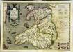
Cambriae typus
1 Karte : Kupferdruck ; 33 x 48 cm Lhuyd; Keere; Mercator; Hondius Henricus Hondius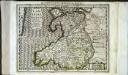
Cambriae typus
1 Karte : Kupferdruck ; 17 x 24 cm Lhuyd; Keere; Mercator Cloppenburgh
Cambriae typvs
1 Karte : Kupferdruck ; 35 x 47 cm Lhuyd; Ortelius s.n.
Cambriae typvs
1 Karte : Kupferdruck ; 35 x 47 cm Lhuyd; Ortelius s.n.
Salopiensis Comitatus cum Staffordiensi. Shropshire & Staffordshire. [Karte], in: Novus atlas absolutissimus, Bd. 7, S. 353.
1 Karte aus Atlas Janssonius Offizin