Maps of Scandinavia

[69][69] Regni Sueciae ..., uit: Atlas sive Descriptio terrarum orbis
Annotatie: Gedigitaliseerde versie. Amsterdam. Heiloo : Picturae (vervaardiger), 2015. tiff-bestand. Gedigitaliseerd: 07-01-2015; Origineel: Universiteitsbibliotheek Vrije Universiteit (XL.05127.-) ; Netherlands; Titelpagina ontbreekt Wit, Frederik de Amsterdam : Frederick de Wit
Regnum Sueciae
Švédsko Lobeck, Tobias Lotter, Tobias Conrad Tobias Lobeck
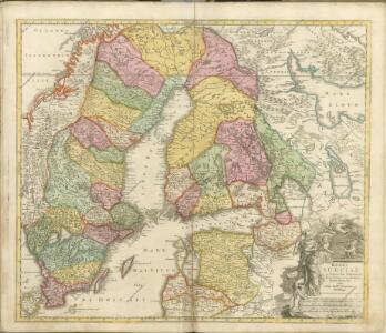
Regni Sueciae in omnes suas subjacentes provincias accurate divisi tabula generalis
1 : 3100000 baltské země Homann, Johann Baptist J. B. Homann
Regni Sueciae tabula generalis, divisa in Sueciae, Gotiaeque regna Finniae ducatum Lapponiam, Livoniam Ingriamque et in omnes subiacentes provincias
1 : 3250000 per F. de Wit Amstelodami Amstelodami : F. de Wit
Suecia Et Norvegia cum sonsiniis [Karte], in: Atlas, sive, Cosmographicae meditationes de fabrica mundi et fabricati figura, S. 128.
1 Karte aus Atlas Mercator, Gerhard
Sueciae regnum cum vicinis regionibus
1 : 15900000 1 Karte : Kupferdruck ; 14 x 17 cm Weigel, Johann Christoph [Johann Christoph Weigel]
Das Koenigreich Schweden und Norwegen / verfertiget von Io. George Schreibern
1 : 12000000 1 Karte : Kupferdruck ; 15 x 20 cm, Bildgr. 16 x 24 cm Schreiber, Johann Georg [J. G. Schreiber]
Suecia Et Norvegia cum sonsiniis [Karte], in: Gerardi Mercatoris Atlas, sive, Cosmographicae meditationes de fabrica mundi et fabricati figura, S. 133.
1 Karte aus Atlas Mercator, Gerhard Montanus, Petrus
La Scandinavie où sont les royaumes de Suede, Danemark et Norwege
1 : 4000000 Jaillot, Alexis Hubert, 1632?-1712 chez Pierre Mortier
Sweden, Norway.
1 : 8600000 Arrowsmith, Aaron; Lewis, Samuel
Sweden, Norway.
1 : 8600000 Arrowsmith, Aaron; Lewis, Samuel
Sueciae magnae, totius orbis regni antiquissimi, hodierna in sex principales suas partes, Gothiam nempe, Sueciam propriam sive stricté Sumptam, Nordlandiam, Finniam, Ingriam, Livoniam
1 : 2700000 Finsko Valk, Gerhard Valk, Leonard per Ge.o et Le.o Valk
Nova mappa geographica Sueciae ac Gothiae regna ut et Finlandiae ducatum ac Lapponiam, cum provinciis minoribus, ob oculos ponens
1 : 3300000 Finsko Lotter, Tobias Conrad sumtibus Tobiae Conradi Lotteri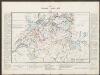
Svecia Et Norvegia cum confinis. [Karte], in: Gerardi Mercatoris et I. Hondii Newer Atlas, oder, Grosses Weltbuch, Bd. 1, S. 96.
1 Karte aus Atlas Mercator, Gerhard und Hondius, Jodocus Jansson, Jan

Karte des Baltischen Meeres
Baltské moře (oblast) Artaria

Svecia et Norvegia cum confinijs
1 Karte : Kupferdruck ; 53 x 46 cm Mercator; Hondius Henricus Hondius
Sweden, Denmark, Norway.
1 : 8500000 Darton, William
Sueciae magnae, totius orbis regni antiquissimi, hodierna in sex principales suas partes, Gothiam nempe, Sueciam propriam sive stricte sumptam, Nordlandiam, Finniam, Ingriam, Livoniam, earundemque subdivisionum, ac adjacentium insularum geographica distinctio
1 : 2900000 ex optimis auctorum descriptionibus collecta, per Ge.o et Le.o Valk [Amsterdam] : G. & L. Valk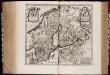
Svecia regnvm / avct. Andrea Bvræo Sveco
1 : 4140000 Annotatie: Kaart van Zweden, Finland en delen van Rusland en de Baltische Zee.; Origineel is Blad 140 in atlas factice; Met opdracht aan Carl (X) Gustavus, Koning van Zweden, door Joan Blaeu; Annotatie geografische gegevens: Met 6 schaalstokken Andreas Bureus 1571-1646 [Amsterdam : Joan Blaeu]
Homannův atlas světa
1 : 5000000

Accuratissima regnorum Sueciae, Daniae et Norvegiae, tabula
1 : 4600000 Dánsko Danckerts, Justus per I. Danckers

Synopsis plagae septentrionalis, sive Sueciae Daniae et Norwegiae regn. accuratissime delineatum
Švédsko Seutter, Matthäus Lotter, Tobias Conrad studio Matth. Seütteri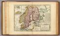
Sweden and Norway.
1 : 9600000 Moll, Herman, d. 1732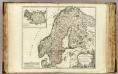
Suede, Norwege, l'Islande.
1 : 3800000 Robert de Vaugondy, Gilles, 1688-1766
Scandinavia complectens Sueciæ, Daniæ & Norvegiæ regna
1 Karte : Kupferdruck ; 47 x 54 cm Homann Johann Baptist Homann
Scandinavia complectens Sueciæ Daniæ & Norvegiæ regna
1 Karte : Kupferdruck ; 47 x 55 cm Homann Johann Baptist Homann