Maps of Mecklenburg-Vorpommern


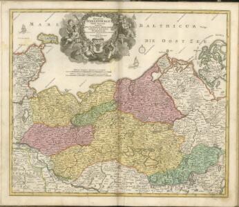
Ducatus Meklenburgici tabula generalis continens duc. Vandaliae et Meklenburg comitatum et episcopatum Swerinensem Rostochiense et Stargardiense dominium
1 : 480000 Meklenbursko (Německo) Homann, Johann Baptist J. B. Homann
[44][44] Ducatus Meklenburgicus ..., uit: Atlas sive Descriptio terrarum orbis
Annotatie: Gedigitaliseerde versie. Amsterdam. Heiloo : Picturae (vervaardiger), 2015. tiff-bestand. Gedigitaliseerd: 07-01-2015; Origineel: Universiteitsbibliotheek Vrije Universiteit (XL.05127.-) ; Netherlands; Titelpagina ontbreekt Wit, Frederik de Amsterdam : Frederick de Wit
Ducatus Mecklenburgici
1 : 480000 Mollova mapová sbírka Seutter, Matthäus Seutter, Matthäus
Meklenburg Ducatus. [Karte], in: Novus Atlas, das ist, Weltbeschreibung, Bd. 1, S. 96.
1 Karte aus Atlas Blaeu, Joan Blaeu, Willem Janszoon
Die Grossherzogthümer Mecklenburg-Schwerin und Mecklenburg Strelitz, den Herzogthümern Holstein und Lauenburg, den Herzogl. Oldenburgischen Fürstenthume Lübeck und den Gebieten der freien Staedte Hamburg und Lübeck / entworfen von C.F. Weiland
1 : 550000 Weiland, C. F. Weimar : Verlag des Geograph. Instituts
Meklenburg Ducatus [Karte], in: Novus atlas absolutissimus, Bd. 2, S. 39.
1 Karte aus Atlas Janssonius Offizin
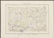
Übersichtskarte von Mittel - Europa

Meklenburg Ducatus [Karte], in: Gerardi Mercatoris et I. Hondii Newer Atlas, oder, Grosses Weltbuch, Bd. 1, S. 280.
1 Karte aus Atlas Mercator, Gerhard und Hondius, Jodocus Jansson, Jan
Lübeck, Stralsund, Stettin
1 : 750000 Lübeck (Německo : oblast) Lorenz, K. K. u. k. Militärgeographisches Institut
Lübeck, Stralsund, Stettin
1 : 750000 Lübeck (Německo : oblast) K. k. militär-geographisches Institut
Maklenburg Ducatus
Meklenbvrg dvcatvs / auctore Ioanne Laurenbergio ; S. Rogiers sculp
1 : 450000 Annotatie: Origineel is Blad 84 in atlas factice; Annotatie geografische gegevens: Met 2 schaalstokken Salomon Rogiers ca 1592- v. 1640; Willem Jansz Blaeu 1571-1638 Amstelodami : Guiljelmus Blaeuw excudit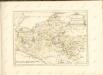
Meklenburg Ducatus. [Karte], in: Theatrum orbis terrarum, sive, Atlas novus, Bd. 1, S. 174.
1 Karte aus Atlas Blaeu, Joan Blaeu, Willem Janszoon
Meklenburg Ducatus. [Karte], in: Le théâtre du monde, ou, Nouvel atlas contenant les chartes et descriptions de tous les païs de la terre, Bd. 1, S. 125.
1 Karte aus Atlas Blaeu, Willem Janszoon und Blaeu, Joan Blaeu, Willem Janszoon
Ducatus Meklenburgicus
1 : 460000 Mollova mapová sbírka Wit, Frederik de Covens, Johannes I
[Die Grossherzogthümer Mechlenburg Schwerin und Strelitz]
Grosser Hand-Atlas über alle Theile der Erde in 170 Karten Meyer, J. Verlag des Bibliographischen Instituts
Mecklenburg, Schwerin, Strelitz Grossherzogthumer.
1 : 620000 Radefeld, Carl Christian Franz, 1788-1874
Die Grosshezogthümer Meklenburg-Schwerin und Meklenburg-Strelitz
1 : 370000 Meklenbursko (Německo) Gräf, C. Luther, Th. Geographisches Institut
Ducatus Meklenburgicus
1 : 460000 Mollova mapová sbírka Ottens, Reinier Ottens, Josua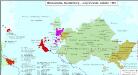
Hansestädte, Mecklenburg und angrenzende Gebiete 1867
Mecklenburg-Strelitz, Mecklenburg-Schwerin, Hansestadt Kunz, Andreas ; Moeschl, Joachim Robert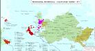
Hansestädte, Mecklenburg und angrenzende Gebiete 1871
Mecklenburg-Strelitz, Mecklenburg-Schwerin, Hansestadt Kunz, Andreas ; Moeschl, Joachim Robert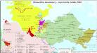
Hansestädte, Mecklenburg und angrenzende Gebiete 1848
Mecklenburg-Strelitz, Mecklenburg-Schwerin, Hansestadt Kunz, Andreas ; Moeschl, Joachim Robert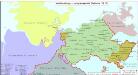
Mecklenburg und angrenzende Gebiete 1812
Mecklenburg-Strelitz, Mecklenburg-Schwerin Hundt, Michael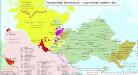
Hansestädte, Mecklenburg und angrenzende Gebiete 1820
Mecklenburg-Strelitz, Mecklenburg-Schwerin, Hansestadt Hundt, Michael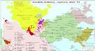
Hansestädte, Mecklenburg und angrenzende Gebiete 1814
Mecklenburg-Strelitz, Mecklenburg-Schwerin, Hansestadt Hundt, Michael