Maps of Lower Franconia

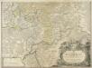
Nova et accuratior repraesentatio geographica Sacr. Rom. Imperii episcopatus Würceburgensis Franciae orientalis ducatus cum omnibus suis praefecturis, et ditionibus eo pertinentibus etc
1 : 380000 Württembersko (Německo) Lotter, Tobias Conrad impensis Tobiae Conradi Lotteri
Nova et accuratior repraesentatio geographica Sacr. Rom. Imperii episcopatus Würceburgensis Franciae orientalis ducatus cum omnibus suis praefecturis, et ditionibus eo pertinentibus etc
1 : 380000 Württembersko (Německo) Lotter, Tobias Conrad impensis Tobiae Conradi Lotteri
Das Franken-Weinland
1 : 493000 Bavorsko (Německo) Hellrung, Carl Ludwig Baensch, E. Rubach'schen Buchhandlung
Kissingen 100, uit: Special-Karte von Mittel-Europa / nach amtlichen Quellen bearbeitet von W. Liebenow
1 : 300000 titelvariant: W. Liebenow's Mittel-Europa; Annotatie: Titel boven de bladen: W. Liebenow's Mittel-Europa Johannes Wilhelm Liebenow 1822-1897 Frankfurt a. M. : Ludwig Ravenstein
Partie Orientale du Temporel de l'Archevesché et Eslectorat de Mayence et le Comté de Reineck
1 : 250000 Mollova mapová sbírka Sanson, Guillaume Covens, Johannes I
Pars Orientalis Temporalis Archiepiscopatvs et Electoratvs Mogvntinensis et Comitatus Reineck
1 : 260000 Mollova mapová sbírka Walther, Johann Georg Hailler, Martin Walther, Johann Georg
Das Franken-Weinland
1 : 505000 Bavorsko (Německo) Hellrung, Carl Ludwig Baensch, E. Rubach'schen Buchhandlung
Comitatus Wertheimici Finitimarumque Regionum Nova Et Exacta Descriptio. [Karte], in: Novus atlas absolutissimus, Bd. 2, S. 180.
1 Karte aus Atlas Janssonius Offizin
Kissingen 100, uit: [W. Liebenow's Special-Karte von Mittel-Europa]
1 : 300000 titelvariant: W. Liebenow's Mittel-Europa; Annotatie: Titel boven de bladen: W. Liebenow's Mittel-Europa Johannes Wilhelm Liebenow 1822-1897 Hannover : Hermann Oppermann
Comitatus Wertheimici Finitimarumque Regionum Nova Et Exacta Descriptio. [Karte], in: Gerardi Mercatoris et I. Hondii Newer Atlas, oder, Grosses Weltbuch, Bd. 1, S. 221.
1 Karte aus Atlas Mercator, Gerhard und Hondius, Jodocus Jansson, Jan
152. Würzburg, uit: Topographische Uebersichtskarte des Deutschen Reiches / herausgegeben v. d. Kartogr. Abt. d. Königl. Preuß. Landesaufnahme
1 : 200000 titelvariant: Topogr. Übersichtskarte des Deutschen Reiches; Annotatie: Titel boven bladen ook: Topogr. Übersichtskarte des Deutschen Reiches; Annotatie geografische gegevens: Op elk blad twee maatstokken: 10 Kilometer = 5,5 cm; 1 geogr. Meile = 3,6 cm; Legenda onder op elk blad Königlich Preußische Landesaufnahme. Kartographische Abtheilung [S.l : Königlich Preußische Landesaufnahme, Kartographische Abtheilung]
Delineatio Geographica generalis comprehendens VI. Foliis Singulos Principatvs Comitatvs Ditiones Dynastias omnes quotquot Imperio Serenissimi Principis Landgrafii Hasso-Darmstadiensis subsunt :
1 : 180000 Mollova mapová sbírka Bronner, Christian Maximilian Homann, Johann Baptista - dědici
COMITATVS | WERTHEIM | cum adjacentibus
[Amsterdam : Joan Blaeu]
Partie Orientale du Temporel de l'Archevesché et Eslectorat de Mayence et le Comté de Reineck
1 : 250000 Mollova mapová sbírka Sanson, Guillaume Jaillot, Alexis Hubert
Der Lauf des Mains
1 : 370000 Aschaffenburg (Německo) Spruner, Karl von Verlag der Stahel'schen Buchhandlung
S. R. I. Principatvs Fvldensis in Bvchonia
1 : 210000 Mollova mapová sbírka Homann, Johann Baptist Homann, Johann Baptista
Section Darmstadt, uit: Charte von dem Grossherzogtum Hessen und dem Herzogtum Nassau / trigonometrisch aufgenommen und hrsg. von C.L.P. Eckhardt
1 : 200000 titelvariant: Karte von Hessen und Nassau Eckhardt, C. L. P Darmstadt : Joh. Wilh. Heyer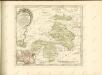

140. Schweinfurt, uit: Topographische Uebersichtskarte des Deutschen Reiches / herausgegeben v. d. Kartogr. Abt. d. Königl. Preuß. Landesaufnahme
1 : 200000 titelvariant: Topogr. Übersichtskarte des Deutschen Reiches; Annotatie: Titel boven bladen ook: Topogr. Übersichtskarte des Deutschen Reiches; Annotatie geografische gegevens: Op elk blad twee maatstokken: 10 Kilometer = 5,5 cm; 1 geogr. Meile = 3,6 cm; Legenda onder op elk blad Königlich Preußische Landesaufnahme. Kartographische Abtheilung [S.l : Königlich Preußische Landesaufnahme, Kartographische Abtheilung]
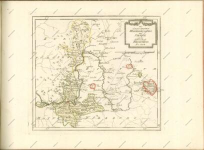
[Dolní Franky]
1 : 219000 Bad Kissingen (Německo) Loehle, Johann Kunstanstalt von Piloty u. Loehle
Gefechte bei Helmstadt und Uettingen
1 : 25000 Popp, A.; Hoffmann, C.
[Gefechtsfelder bei Würzburg und Aschaffenburg von 1866]
1 : 50000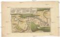
Der Mayn Strohm, von Obernau bis Seeligenstadt sambt umliegender Gegend, und sonderlich dem, d. 27 Juni 1743. bey Dettingen fürgefallenen Treffen

Plan zu den Gefechten vor Würzburg
1 : 25000 Königl. Staatsdr.
Meßtischblatt 11 : Wittighausen, 1881
1 : 250000 Wittighausen. - [Ausg.] 1881. - 1:25000. - Leipzig: Giesecke & Devrient, 1881. - 1 Kt.
Meßtischblatt 10 : Grünsfeld, 1932
1 : 250000 Grünsfeld. - Hrsg. 1881/82, wichtigere Nachtr. 1932. - 1:25000. - Karlsruhe: Kunstdr. Künstlerbund, 1932. - 1 Kt.
Meßtischblatt 10 : Grünsfeld, 1882
1 : 250000 Grünsfeld. - [Ausg.] 1881/82. - 1:25000. - Leipzig: Giesecke & Devrient, 1882. - 1 Kt.
Meßtischblatt 9 : Tauberbischofsheim, 1928
1 : 250000 Tauberbischofsheim. - Revid. 1881 und 1886, wichtigere Nachtr. 1928. - 1:25000. - Karlsruhe: Kunstdr. Künstlerbund, 1928. - 1 Kt.