Maps of Scandinavia


Suecia Et Norvegia cum sonsiniis [Karte], in: Gerardi Mercatoris Atlas, sive, Cosmographicae meditationes de fabrica mundi et fabricati figura, S. 133.
1 Karte aus Atlas Mercator, Gerhard Montanus, Petrus
Svecia Et Norvegia cum confinis. [Karte], in: Gerardi Mercatoris et I. Hondii Newer Atlas, oder, Grosses Weltbuch, Bd. 1, S. 96.
1 Karte aus Atlas Mercator, Gerhard und Hondius, Jodocus Jansson, Jan
[Skandinavien]
Skandinávie
Suede, Norwege, l'Islande.
1 : 3800000 Robert de Vaugondy, Gilles, 1688-1766
SVECIA, | DANIA, ET NORVEGIA, | Regna Europæ Septentrionalia.
Iuxta Archetypum Andreæ Buræi de Boo, | Secretarij Regij, et supremi Regni Sueciæ | Architecti. [Amsterdam : Joan Blaeu]
Nieuwe kaart van Noorwegen, Zweden, Denemarken en een gedeelte van Rusland
1 : 12500000 [S.l.] : [s.n.]
Exactissima totius Scandinaviae tabula
Skandinávie Visscher, Nicolaes Jansz. Siebert, Selmar per Nicolaum Visscher
Sweden and Norway.
1 : 9600000 Moll, Herman, d. 1732
La Scandinavie où sont les royaumes de Suede, Danemark et Norwege
1 : 4000000 Jaillot, Alexis Hubert, 1632?-1712 chez Pierre Mortier
Karte von dem Koenigreiche Schweden
1 : 3000000 Skandinávie Reilly, Franz Johann Josef von Müller, Franz Franz Ioh. Ios. von Reilly
Karte von dem Koenigreiche Schweden
1 : 3000000 Rusko severozápadní Reilly, Franz Johann Josef von Müller, Franz Franz Ioh. Ios. von Reilly
Svecia, Dania, Et Norvegia, Regna Europae Septentrionalia [Karte], in: Novus Atlas, das ist, Weltbeschreibung, Bd. 1, S. 39.
1 Karte aus Atlas Blaeu, Joan Blaeu, Willem Janszoon
Svecia et Norvegia cum confinijs
1 Karte : Kupferdruck ; 53 x 46 cm Mercator; Hondius Henricus Hondius
Suecia Et Norvegia cum sonsiniis [Karte], in: Atlas, sive, Cosmographicae meditationes de fabrica mundi et fabricati figura, S. 128.
1 Karte aus Atlas Mercator, Gerhard

Sueciae, Norvegiae, et Daniae, Nova Tabula. [Karte], in: Novus atlas absolutissimus, Bd. 1, S. 42.
1 Karte aus Atlas Janssonius Offizin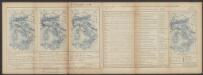
Suecia, Dania, Et Norvegia, Regna Europae Septentrionalia. [Karte], in: Le théâtre du monde, ou, Nouvel atlas contenant les chartes et descriptions de tous les païs de la terre, Bd. 1, S. 55.
1 Karte aus Atlas Blaeu, Willem Janszoon und Blaeu, Joan Blaeu, Willem Janszoon
Synopsis plagae septentrionalis, sive Sueciae Daniae et Norwegiae regn. accuratissime delineatum
Švédsko Seutter, Matthäus Lotter, Tobias Conrad studio Matth. Seütteri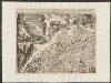
Suecia, Dania, Et Norvegia, Regna Europae Septentrionalia. [...] [Karte], in: Theatrum orbis terrarum, sive, Atlas novus, Bd. 1, S. 53.
1 Karte aus Atlas Blaeu, Joan Blaeu, Willem Janszoon
Tabula exactissima Regnorum Sueciae et Norvegiae, nec non Maris Universi Orientalis [...] [Karte], in: Novus atlas absolutissimus, Bd. 1, S. 45.
1 Karte aus Atlas Janssonius Offizin
Sueciae regnum cum vicinis regionibus
1 : 15900000 1 Karte : Kupferdruck ; 14 x 17 cm Weigel, Johann Christoph [Johann Christoph Weigel]
Das Koenigreich Schweden und Norwegen / verfertiget von Io. George Schreibern
1 : 12000000 1 Karte : Kupferdruck ; 15 x 20 cm, Bildgr. 16 x 24 cm Schreiber, Johann Georg [J. G. Schreiber]
Nieuwe kaart van Noord-Europa / door A. de Moor
1 : 3250000 Moor, A. de (fl. 1920) [S.l. : Zijlstra]
SUECIAE Regnum cum vicinis Regionibus
Finsko
La Scandinavie et les environs, ou sont les royaumes de Suede, de Danemark, et de Norwege
1 : 4800000 Dánsko Sanson, Guillaume Schenk, Pieter chez Pierre Schenk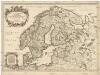
La Scandinavie et les environs
1 : 4800000 Dánsko Sanson, Guillaume Cordier, Louis chez H. Iaillot
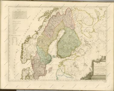
Scandinavia complectens Sueciæ, Daniæ & Norvegiæ regna
1 Karte : Kupferdruck ; 47 x 54 cm Homann Johann Baptist Homann
Scandinavia complectens Sueciæ Daniæ & Norvegiæ regna
1 Karte : Kupferdruck ; 47 x 55 cm Homann Johann Baptist Homann