Maps of Landkreis Passau

Sacri Romani imperii circuli et electoratus Bavariae tabula, 6
6 Blätter : s.n.
Charte der Inn und Hausruck Viertel in dem Erzherzogthume Niederöstreich uiber der Enns
1 : 440000 Dolní Rakousko (Rakousko) Liechtenstern, Joseph Marx von Bendovsky, Thomas bey Joh. Schönberg
Salzburg
1 : 200000 Herder, Benjamin
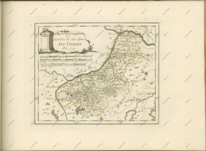
Das Inn Viertel in dem Erzherzogthum Oesterreich ob der Enns
1 : 170000 Augsburg : Tobias Conrad Lotter
Das Inn Viertel in dem Erzherzogthum Oesterreich ob der Enns
1 : 230000 Horní Rakousko (Rakousko) Balzer, Řehoř Anton Elsenwanger
Das Inn Viertel in dem Erzherzogthum Oesterreich ob der Enns
1 : 230000 Bavorsko (Německo) Balzer, Řehoř Anton Elsenwanger
Das Inn Viertel in dem Erzherzogthum Oesterreich ob der Enns
1 : 230000 Bavorsko (Německo) Balzer, Řehoř Anton Elsenwanger
Das Inn Viertel in dem Erzherzogthum Oesterreich ob der Enns
1 : 170000 Horní Rakousko (Rakousko) Lotter, Tobias Conrad Tobias Conrad Lotter
Neuer Siegreicher Plan der königl. Hungar; und Böhm. victoriosen Action welche den 9. May Ano. 1743 bey Braunau vorgefallen, sambt allen von 6ten biß 14. May vorbeygegangenen Operationen
Mollova mapová sbírka Lidl, Johann Jakob Lidl, Johann Jacob
Pars VI designat partem orientem regiminis Landh: et Straub; infer partem ditionis Burchh; episc: Patav; com: Ortemb: et Neoburg; cum oris archid: Austriæ
1 Karte : 54 x 52 cm Heinrich Ludwig Broenner
Theil von Bayern
Bavorsko (Německo) Streit, Friedrich Wilhelm Geograph. Institut
182. Burghausen, uit: Topographische Uebersichtskarte des Deutschen Reiches / herausgegeben v. d. Kartogr. Abt. d. Königl. Preuß. Landesaufnahme
1 : 200000 titelvariant: Topogr. Übersichtskarte des Deutschen Reiches; Annotatie: Titel boven bladen ook: Topogr. Übersichtskarte des Deutschen Reiches; Annotatie geografische gegevens: Op elk blad twee maatstokken: 10 Kilometer = 5,5 cm; 1 geogr. Meile = 3,6 cm; Legenda onder op elk blad Königlich Preußische Landesaufnahme. Kartographische Abtheilung [S.l : Königlich Preußische Landesaufnahme, Kartographische Abtheilung]
Archiducatus Austriae Superioris Geographica Descriptio. facta Anno 1667
1 : 150000 Mollova mapová sbírka Vischer, Georg Matthaeus Küssel, Melchior
Archiducatus Austriae Superioris Geographica Descriptio. facta Anno 1667
1 : 150000 Mollova mapová sbírka Vischer, Georg Matthaeus Küssel, Melchior
designat partem orientem Regiminis Landh: et Straub; Infer Partem ditionis Burchh; Episc: Patav; Com: Ortemb: et Neoburg; cum oris Archid: Austriæ
1 : 150000 Mollova mapová sbírka Buna, Wilhelm C. Broenner, Heinrich Ludwig
[Umgebungen von Ried]
David, J.
Archiducatus Austriae Superioris Geographica Descriptio. facta Anno 1667
1 : 150000 Mollova mapová sbírka Vischer, Georg Matthaeus Küssel, Melchior
Salzburg.
1 : 462000 Radefeld, Carl Christian Franz, 1788-1874
183. Neuhaus (a. Inn.), uit: Topographische Uebersichtskarte des Deutschen Reiches / herausgegeben v. d. Kartogr. Abt. d. Königl. Preuß. Landesaufnahme
1 : 200000 titelvariant: Topogr. Übersichtskarte des Deutschen Reiches; Annotatie: Titel boven bladen ook: Topogr. Übersichtskarte des Deutschen Reiches; Annotatie geografische gegevens: Op elk blad twee maatstokken: 10 Kilometer = 5,5 cm; 1 geogr. Meile = 3,6 cm; Legenda onder op elk blad Königlich Preußische Landesaufnahme. Kartographische Abtheilung [S.l : Königlich Preußische Landesaufnahme, Kartographische Abtheilung]
Quartus Quadrans Das Mühl-Viertl
1 : 530000 Mollova mapová sbírka Fuhrmann, Mathias Märtin, Johann Heinrich Heyinger, Johann Ignaz
Quartus Quadrans Das Mühl-Viertl
1 : 530000 Mollova mapová sbírka Insprugger, Sebastianus Märtin, Johann Heinrich Schwendimann, Wolfgang
Das Hoch-Fürstl: Erzstifft Salzburg sambt Angräntzenden Orthen
1 : 1600000 Mollova mapová sbírka Seutter, Matthäus Seutter, Matthäus
Special-Karte für die Schluss-Manöver des 14. Corps 1890
1 : 75000 Horní Rakousko (Rakousko) K. u. k. militär-geographisches Institut
Mattighofen.
from Spezialkarte der osterreichisch-ungarischen Monarchie.
Reid und Vocklabruck.
from Spezialkarte der osterreichisch-ungarischen Monarchie.
Braunau und Triftern.
from Spezialkarte der osterreichisch-ungarischen Monarchie.
Schading.; Spezialkarte der osterreichisch-ungarischen Monarchie.
from Spezialkarte der osterreichisch-ungarischen Monarchie. Austro-Hungarian Monarchy. Militärgeographisches Institut.,
Umgebungen von Dittmoning