Maps of Sahara


[General Karte des Osmanischen Reiches]
Grosser Hand-Atlas über alle Theile der Erde in 170 Karten Meyer, J. Verlag des Bibliographischen Instituts

Estats del'Empire du Grand Seigneur des Turcs
1 : 11200000 Mollova mapová sbírka Jaillot, Alexis-Hubert Ottens, Josua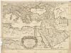
Estats de l'empire du Grand Seigneur des Turcs, en Europe, en Asie, et en Afrique
1 : 10700000 Afrika severní Sanson, Guillaume Cordier, Louis chez H. Iaillot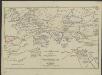
[Hierographie, oder topographisch-synchronistische Darstellung der Geschichte der christlichen Kirche] : VII. Von Gregor d. Gr. bis auf Carl d. G. J. 604-800
1 : 8400000 W.A. Möller Lith. bey Arnz & Co. in Düsseldorf Elberfeld : Büschler
Europa antiqua cum finitimis Africæ & utriusque Asiæ regionibus / Nicolaus Blancardus ... delineabat
1 : 10000000 Annotatie: Origineel is Blad 2 in atlas factice Blanckaert, Nicolaas [Amsterdam : Joannes Janssonius]
Verbreitung der Religionen im Anfange von Justinians Regierung
1 : 30000000 Europa Justinian I., Byzantinisches Reich, Kaiser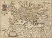
Europa Antiqua cum finitimis Africae & utriusque Asiae regionibus. [Karte], in: Novus atlas absolutissimus, Bd. 10, S. 33.
1 Karte aus Atlas Janssonius Offizin
Turcicum imperium
1 : 11300000 1 Karte : Kupferdruck ; 44 x 54 cm Wit, Frederick de apud F. de Wit
Carte Générale de L'Empire Ottoman en Europe, en Asie et en Afrique
Nouvel atlas physique politique et historique de l'Empire ottoman et des états limitrophes en Europe, en Asie et en Afrique, en quarante feuilles Hellert, J.J. Bellizard, Dufour et Cie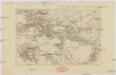
Mundus quem perlustraverunt descripseruntq[ue] ... Beniamin ben Ionahidelensis 1160-1173 et ... Petahia ratisboensis 1175
Afrika severní
[Hierographie, oder topographisch-synchronistische Darstellung der Geschichte der christlichen Kirche] : VI. Von Constantin bis auf Gregor d. G. J. 325-604
1 : 8400000 W.A. Möller Lith. bey Arnz & Co. in Düsseldorf Elberfeld : Büschler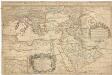
Estats de l'empire du Grand Seigneur des Turcs en Europe, en Asie, et en Afrique
1 : 8540000 Afrika Sanson, Nicolas Jaillot, Alexis-Hubert H. Iaillot
Stato del gran Tvrco
1 : 10000000 Afrika severní Sanson, Guillaume Cantelli, Giacomo Gio. Giacomo Rossi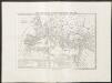
Carta generale dell'impero romano sotto Costantino
1 : 11000000 Marzolla, Benedetto [Verlag nicht ermittelbar]
Turcicum imperium
osmanská říše
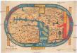
Terre aux trois fils de Noe.
1 : 23500000 Houze, Antoine Philippe
Estats de l'empire du Grand Seigneur des Turcs en Europe, en Asie, et en Afrique
1 : 12930000 Afrika Sanson, Nicolas Probst, Johann Michael Jean Michel Probst
Estats de l'empire du grand seigneur des Turcs en Europe, en Asie, et en Afrique
1 : 12930000 Afrika Sanson, Nicolas Probst, Johann Michael Jean Michel Probst
[Hierographie, oder topographisch-synchronistische Darstellung der Geschichte der christlichen Kirche] : IV. Von Constantin bis auf Gregor d. G. J. 325-604
1 : 8400000 W.A. Möller Lith. bey Arnz & Co. in Düsseldorf Elberfeld : Büschler
[Geschichtlich-geographischer Atlas von Europa :] III. Karte des Roemischen Reichs in seiner grössten Ausdehnung
entworfen und gezeichnet durch Ferd. Aug. v. Witzleben Gestochen bei K. Kolbe von Leop. Müller [Berlin etc.] : [Mittler]
[Hierographie, oder topographisch-synchronistische Darstellung der Geschichte der christlichen Kirche] : II. Von Paulus bis Origines
1 : 8400000 W.A. Möller Lith. bey Arnz & Co. in Düsseldorf Elberfeld : Büschler
Carte des peuples de l’Europe centrale lors de l’apparation des Huns, au 4e siècle de notre ère
Mitteleuropa ethnische Gruppe, Völkerwanderungszeit
[Hierographie, oder topographisch-synchronistische Darstellung der Geschichte der christlichen Kirche] : I. Zeiten der Apostel
1 : 8400000 W.A. Möller Lith. bey Arnz & Co. in Düsseldorf Elberfeld : Büschler
Turcicum Imperium [Karte], in: Novus Atlas, das ist, Weltbeschreibung, Bd. 2, S. 289.
1 Karte aus Atlas Blaeu, Joan Blaeu, Willem Janszoon
[Hierographie, oder topographisch-synchronistische Darstellung der Geschichte der christlichen Kirche] : V. Von Constantin bis auf Gregor d. G. J. 325-604
1 : 8400000 W.A. Möller Lith. bey Arnz & Co. in Düsseldorf Elberfeld : Büschler
[Geschichtlich-geographischer Atlas von Europa :] IV. Karte Europa’s Während der Blüthe des Ost-Gothischen Reichs unter Theodorich im Anfange des 6ten Jahrhundert’s; nebst den Zügen Alarich’s und Attila’s
entworfen und gezeichnet durch F.A. v. Witzleben Gest. bei K. Kolbe von H. Hertzberg [Berlin etc.] : [Mittler]
Gemälde der grossen Wanderungen der Barbaren
Historisch-genealogisch-geographischer Atlas von Le Sage Las Cases, Emmanuel Auguste Dieudonné Marius Joseph de Johann Velten, Kunsthändler