Maps of Savoy


Département du Mont Blanc
1 Karte : Kupferdruck ; 43 x 38 cm Capitaine s.n.
Tabvla generalis Sabavdiæ
1 Karte : Kupferdruck ; 49 x 58 cm Blaeu; Borgonio; Broen Ottens ...hos
Tabvla generalis Sabavdiæ
1 Karte : Kupferdruck ; 49 x 58 cm Blaeu; Borgonio; Broen Joannes Blaeu excudit
Le département du Mont-Blanc
1 Karte : Kupferdruck ; 58 x 52 cm Raymond; Boutrois chez l'auteur rue des Maçons-sorbonne no. 441
Sabavdia dvcatvs
1 Karte : Kupferdruck ; 36 x 48 cm Janssonius apud Joan: Janssonium
Sabavdia dvcatvs
1 Karte : Kupferdruck ; 36 x 47 cm Valck; Schenk apud G. Valk et P. Schenk
Sabavdia dvcatvs
1 Karte : Kupferdruck ; 36 x 47 cm Blaeu apud Guiljelmum Blaeuw
Sabaudia ducatus
1 Karte : Kupferdruck ; 17 x 24 cm Mercator Cloppenburgh
Sabaudia ducatus
1 Karte : Kupferdruck ; 35 x 48 cm Hondius; Goos Judocus Hondius excudit
STATVVM ITALIAE SVPERIORIS vulgo olim LOMBARDIA dictorum geographica Delineatio
Lombardie (Itálie) Mayer, Tobias edentibus Homannianis Heredibus
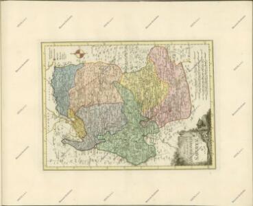
SABAVDIA | DVCATVS. | SAVOYE
Amsterdami | Apud Guiljelmum Blaeuw
Karte von dem Herzogthume Savoyen und den Grafschaften Nizza, Tenda und Borgio, oder den Ländern welche der König von Sardinien in dem Frieden zu Paris den 15. May 1796 der französischen Republik abtrat
1 : 570000 Nice (Francie)
La Savoye
1 Karte : Kupferdruck ; 38 x 29 cm, Bildgrösse 40 x 54 cm Duval chez l'autheur en l'Isle du palais sur le quay de l'Orloge proche le coin de la ruë de Harlay
Sabaudia Ducatus. Savoye [Karte], in: Theatrum orbis terrarum, sive, Atlas novus, Bd. 2, S. 163.
1 Karte aus Atlas Blaeu, Joan Blaeu, Willem Janszoon
Sabaudia Ducatus. Savoye [Karte], in: Le théâtre du monde, ou, Nouvel atlas contenant les chartes et descriptions de tous les païs de la terre, Bd. 2, S. 161.
1 Karte aus Atlas Blaeu, Willem Janszoon und Blaeu, Joan Blaeu, Willem Janszoon
Sabaudia Ducatus. Savoye [Karte], in: Novus Atlas, das ist, Weltbeschreibung, Bd. 2, S. 162.
1 Karte aus Atlas Blaeu, Joan Blaeu, Willem Janszoon
Duché de Savoye qui comprend le Chablais, le Fossigny, le Génovois, le Savoye propre, la Tarentaise et la Maurienne
1 : 350000 Savojsko Robert de Vaugondy, Gilles Borgonio, Giovanni Tommaso C. F. Delamarche
Duche de Savoye.
1 : 325000 Robert de Vaugondy, Gilles, 1688-1766
Sabaudia Ducatus La Savoié [Karte], in: Gerardi Mercatoris et I. Hondii Newer Atlas, oder, Grosses Weltbuch, Bd. 2, S. 146.
1 Karte aus Atlas Mercator, Gerhard und Hondius, Jodocus Jansson, Jan
Sabaudia Ducatus. Savoye [Karte], in: Novus atlas absolutissimus, Bd. 4, S. 233.
1 Karte aus Atlas Janssonius Offizin
Les duchez de Savoye, de Chablais, et de Genevois, les comtez de Maurienne, et de Tarantaise, et la baronie de Fausigny
1 Karte : Kupferdruck ; 52 x 41 cm Fer chez le Sr. de Fer geographe de Sa Majesté catholique et de Monseigneur le dauphin dans l'Isle du palais sur le quay de l'Orloge a la sphere royale
Le département du Mont-Blanc
1 : 377000 Mont Blanc (Francie a Itálie) Raymond, J. B. Boutrois J.B. Raymond
Sabaudia ducatus
1 : 440000 Savojsko Hondius, Jodocus Judocus Hondius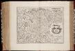
Sabavdia dvcatvs = Savoye
1 : 520000 titelvariant: Savoye; Annotatie: Origineel is Blad 153 in atlas factice; Annotatie geografische gegevens: Schaalstokken op kaart: 6 Milliaria Gallica (= 6,3 cm), en: 20 Milliaria Italica (= 7 cm) Amsterdami : apud Joan: Janssonium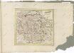

Département du Mont Blanc
1 : 260000 Mont Blanc (Francie a Itálie) Houdan, François d' P. G. Chanlaire
Duché de Savoye
1 Karte : Kupferdruck ; 46 x 49 cm Santini; Remondini; Borgonio; Robert de Vaugondy chez Mr. Remondini