Maps of Italy


Totius Italiae Tabula. [Karte], in: Novus atlas absolutissimus, Bd. 5, S. 14.
1 Karte aus Atlas Janssonius Offizin
Map of Italy.
1 : 6050000 Bowen, Emanuel
Nieuwe kaart van geheel Italien, volgens de laatste verbeteringen
1 : 7500000 [S.l.] : [s.n.]
[27][27]Novissima et accuratissima totius Italiae, Corsicae et Sardiniae descriptio, uit: Atlas sive Descriptio terrarum orbis
Annotatie: Gedigitaliseerde versie. Amsterdam. Heiloo : Picturae (vervaardiger), 2015. tiff-bestand. Gedigitaliseerd: 07-01-2015; Origineel: Universiteitsbibliotheek Vrije Universiteit (XL.05127.-) ; Netherlands; Titelpagina ontbreekt Wit, Frederik de Amsterdam : Frederick de Wit
L'Italie
1 : 2580000 Itálie Delisle, Guillaume Riccioli, Giovanni Battista G. de l'Isle
Tabula Europae VI. [Karte], in: Geographia universalis vetus et nova complectens Claudii Ptolemaei Alexandrini enarrationis libros VIII, S. 239.
1 Karte aus Atlas Münster, Sebastian [und Ptolemaeus, Claudius]
Tabula Europae VI. [Karte], in: Claud. Ptolemaeus. Geographia lat. cum mappis [...], S. 269.
1 Karte aus Atlas Münster, Sebastian [und Ptolemaeus, Claudius]
Homannův atlas světa
1 : 2100000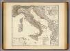
Italia, Gallia citerior, Illyricum, Sicilia, Sardinia, Corsica.
1 : 3900000 Menke, Th.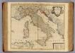
L'Italie.
1 : 2600000 L'Isle, Guillaume de, 1675-1726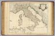
L'Italie.
1 : 2600000 L'Isle, Guillaume de, 1675-1726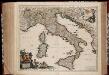
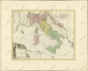
Totius Italiæ tabula / per Nicolaum Visscher
1 : 3000000 Annotatie: Cum privilegio Ordinum Holland[iæ] et West-Fris[iæ]; Met opdracht van N. Visscher aan Cosmo III van Toscane; Origineel is Blad 151 in atlas factice; Annotatie geografische gegevens: Met 3 schaalstokken; Legenda Nicolaes Jansz. Visscher jr. 1649-1702 [Amsterdam : N. Visscher]
Italien.
1 : 3700000 Petermann, A.
Italy.
1 : 6400000 Arrowsmith, Aaron; Lewis, Samuel
Italy.
1 : 6400000 Arrowsmith, Aaron; Lewis, Samuel
L'Italie distinguée suivant l'estendüe de tous les Estats, Royaumes, Republiques, Duchés, Pricipautés qui la partagent presentement [Karte], in: Atlas nouveau, contenant toutes les parties du monde [...], Bd. 2, S. 121.
1 Karte aus Atlas Sanson, Nicolas Jaillot, Alexis Hubert und Mortier, Pieter
Italien
Hand-Atlas über alle Theile der Erde und über das Weltgebäude Stieler, Adolf Justus Perthes
Karte von Italien
1 : 3040000 Itálie Reilly, Franz Johann Josef von Anville, Jean-Baptiste Bourguinon d' Franz Joh. Jos. von Reilly
Italy, and Sardinia.
1 : 3700000 Carey, Mathew
Italy, and Sardinia.
1 : 3780000 Carey, Mathew
Italy, and Sardinia.
1 : 4118400 Carey, Mathew
Italy and Sardinia.
1 : 3801600 Carey, Mathew
Italy and Sardinia.
1 : 3801600 Carey, Mathew
Italien
Neuester Schul-Atlas Walch, Johann im Verlag bei Joh. Walch
Italien
Adolf Stieler's Handatlas über alle Theile der Erde und über das Weltgebäude Stieler, Adolf Justus Perthes