Maps of West Flanders

[Carte de la Belgique]
1 : 160000 Belgie Institut cartographique militaire
Kriegsgeologische Uebersichtskarte für den Stellungsbau : Zusammendruck für die 4. Armee
1 : 20000 Relief shown by spot heights and hachures. War Geological overview map of the fortifications. "Stand der Erkundung: 1. September 1918." " ... am 12.9.18." "Lfd. Nr. 3297." Germany. Heer. Stoverm IV. Geologengruppe.; Germany. Heer. Vermessungs-Abteilung 24. Germany : Gruppen-Kartenstelle II, Verm. Abtlg. 24
EPISCOPATVS | BRVGENSIS
[Amsterdam : Joan Blaeu]
Pars Flandriae orientalis; Franconatum, insulam Causant etc. Civitatesque Gaudavum, Brugas, [...] [Karte], in: Gerardi Mercatoris et I. Hondii Newer Atlas, oder, Grosses Weltbuch, Bd. 1, S. 422.
1 Karte aus Atlas Mercator, Gerhard und Hondius, Jodocus Jansson, Jan
Pars Flandriae orientalis; Franconatum, insulam Causant etc. Civitatesque Gaudavum, Brugas, [...] [Karte], in: Novus atlas absolutissimus, Bd. 3, S. 121.
1 Karte aus Atlas Janssonius Offizin
Flandriae Teutonicae Pars Orientalior [Karte], in: Novus Atlas, das ist, Weltbeschreibung, Bd. 1, S. 357.
1 Karte aus Atlas Blaeu, Joan Blaeu, Willem Janszoon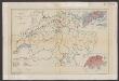
Flandriae Teutonicae Pars Orientalior [Karte], in: Le théâtre du monde, ou, Nouvel atlas contenant les chartes et descriptions de tous les païs de la terre, Bd. 1, S. 394.
1 Karte aus Atlas Blaeu, Willem Janszoon und Blaeu, Joan Blaeu, Willem Janszoon
Flandriae Teutonicae Pars Orientalior [Karte], in: Theatrum orbis terrarum, sive, Atlas novus, Bd. 1, S. 370.
1 Karte aus Atlas Blaeu, Joan Blaeu, Willem Janszoon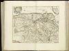
[107][110] Pars Flandriae orientalis ..., uit: Atlas sive Descriptio terrarum orbis
Annotatie: Gedigitaliseerde versie. Amsterdam. Heiloo : Picturae (vervaardiger), 2015. tiff-bestand. Gedigitaliseerd: 07-01-2015; Origineel: Universiteitsbibliotheek Vrije Universiteit (XL.05127.-) ; Netherlands; Titelpagina ontbreekt Wit, Frederik de Amsterdam : Frederick de Wit
FRANCONATVS, | Vulgo | HET VRYE
Guilielmus et Iohannes Blaeuw exc. Amsterdami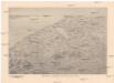
Reliefkarte von Flandern
Flandry Franckh'sche Verlagshandlung

Flandriae comitatus pars media, comprehendens castellaniam Yprensem, Cortracensem, Aldenardensem
1 : 130000 per Nicol. Visscher Amst. Bat. Amst. Bat. : per Nicol. Visscher
IPRENSIS | Episcopatus
Ioh. Blaeu excud.
Carte Particuliere des environs de Menin, Courtray, Ypre, Dixmude et Deynse
1 : 250000 Mollova mapová sbírka Seutter, Matthäus Seutter, Matthäus
FLANDRIÆ | TEVTONICÆ | PARS ORIENTALIOR
Guilielmus et Iohannes Blaeuw exc. Amsterdami
CASTELLANIÆ | CORTVRIACENSIS | TABVLA
[Amsterdam : Joan Blaeu]
NOVA ET EXACTA TABVLA GEOGRAPHICA SALÆ ET CASTELLANIÆ IPRENSIS. De Casselrie van Ipre. LA CHASTELENIE D'IPRE. ANNO M DC XXXXI
Vedastus du Plouich fec. Henricus Hondius excudebat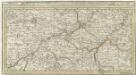
Menin in Flandern mitt nahe gelegenen Staedtten Ypern, Cortryck, Ryssel, Dornick etc.
1 : 250000 Mollova mapová sbírka Bodenehr, Gabriel Bodenehr, Gabriel
Franconatvs vulgo het Vrye
1 : 190000 Nizozemsko Blaeu, Joan Guiljelmus et Iohannes Blaeuw
Carte Particuliere des environs de Menin, Courtray, Ypre, Dixmude et Deynse
1 : 116600 Mollova mapová sbírka Fricx, Eugène Henry Harrewyn, Jacques Fricx, Eugené Henry
Flandriae Comitatus Pars Septentrionalis
1 : 133000 Mollova mapová sbírka Visscher, Nicolaes Schenk, Peter II
Flandriae Comitatus Pars Media
1 : 133000 Mollova mapová sbírka Visscher, Nicolaes Schenk, Peter II
Carte particuliere des environs de Menin, Courtray, Ypre, Dixmunde, et Deynse
1 : 110000 Belgie Fricx, Eugene Henry chez Eugene Henry Friex
Map of water supply: Ostend
1 : 100000 Series of maps on water supplies. Ostend. War Office
VI, uit: Carte chorographique des Pays-Bas Autrichiens / ... par le Comte de Ferraris ; gravée par L.A. Dupuis
1 : 86400 Annotatie: Lit.: Les militaires et la cartographie des Pays-Bas méridionaux et de la Principauté de Liège à la fin du XVIIe et au XVIII siècle / Claire Lemoine-Isabeau. - Bruxelles, 1984, p. 206-212; La cartographie au XVIIIe siècle et l'oeuvre du Comte de Ferraris (1726-1814) : colloque international, Spa, 8-11 sept. 1976. - Bruxelles, 1978; Met opdracht aan keizer Joseph II (bl.XVI); Met plattegrond van Brussel (bl. XXI), overzichtskaart (bl. XXII) en bladwijzer (bl. XXIII); Ontbreekt: bl. I-III en XXI; Voor aanwezige bladen zie overzichtsblad Ferraris, Johann Joseph; Dupuis, L. A. [S.l. : s.n.]
Theatre de La Guerre dans les Pais Bas et en France, Depuis La Haie jusqu'a Partis; ousont. Les Partis Meridionales d'Hollande et d'Utrecht La Zeelande La Flandre Le Brabant - Le Namur, L'Hainaut L'Artois, La Picardie, La Champagne, L'Isle de France :
1 : 250000 Mollova mapová sbírka Allard, Abraham Allart, Abraham