Maps of Iran


Iran und Turan, (Persien, Afghanistan, Beludschistan, Turkestan)
Hand-Atlas über alle Theile der Erde nach dem neuesten Zustande und über das Weltgebäude Stieler, Adolf bei Justus Perthes
Persia, Caspian Sea, part of Independent Tartary.
1 : 13200000 Moll, Herman, d. 1732
Iran und Turan oder Persien, Afghanistan, Belutschistan & Türkestan
Hand-Atlas über alle Theile der Erde und über das Weltgebäude Stieler, Adolf Justus Perthes

Iran und Turan, (Persien, Afghanistan, Beludschistan, Turkestan)
Hand-Atlas über alle Theile der Erde nach dem neuesten Zustande und über das Weltgebäude Stieler, Adolf bei Justus Perthes
West-Asien.
1 : 9700000 Stein, Christ. Gottfr. Dan.
Persia Sive Sophorum Regnum [Karte], in: Le théâtre du monde, ou, Nouvel atlas contenant les chartes et descriptions de tous les païs de la terre, Bd. 2, S. 260.
1 Karte aus Atlas Blaeu, Willem Janszoon und Blaeu, Joan Blaeu, Willem Janszoon
Empire d'Alexandre.
1 : 10000000 Picquet, C.
[Historisch-geographischer Atlas zu den allgemeinen Geschichtswerken von C. v. Rotteck, Pölitz u. Becker] : Das Reich Alexanders des Grossen mit besonderer Angavbe Macedoniens unter Philipp u. der nach der Schlacht bei Ipsus entstandenen Reiche
von Julius Loewenberg Lithographie von B. Herder in Freiburg im Breisgau [Freiburg im Breisgau] : [Herder]
Impero di Alessandro
1 : 10000000 Marzolla, Benedetto [Verlag nicht ermittelbar]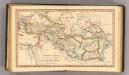
Alexandri Itinera.
1 : 20500000 Fenner, Rest.
Persia Sive Sophorum Regnum [Karte], in: Theatrum orbis terrarum, sive, Atlas novus, Bd. 2, S. 269.
1 Karte aus Atlas Blaeu, Joan Blaeu, Willem Janszoon
Nieuwe kaart van 't ryk van Persie
1 : 9000000 Annotatie: Oorspr. verschenen in: Nieuwe hand-atlas ... - Amsterdam : Tirion, 1744 Amsterdam : Isaak Tirion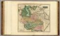
Persia.
1 : 6250000 Thomson, John
(Das Reich Kalifen in seiner grossten Ausdehnung) - Ost.
1 : 15200000 Spruner von Merz, Karl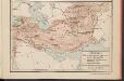
L'Hellénisme dans l'Antiquité [II]
Makedonien Hellenismus Altertum Kümmerly & Frey
Theatrum historicum ad annum Christi quadrigentesimũ : in quo tũ Imperii Romani tũ Barbarorum circumincolentium status ob oculos ponitur pars orientalis
1 : 8500000 L'Isle, Guillaume de, 1675-1726 Apud I. Covens & C. Mortier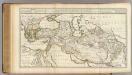
Alexandri Magni Imperium et Expeditio.
1 : 6800000 L'Isle, Guillaume de, 1675-1726
Iran, Turan und West Turkestan
Schul-Atlas in 36 Karten Völter, Daniel Verlag der J.M. Dannheimer'schen Buchhandlung
PERSIA | Sive | SOPHORVM | REGNVM
[Amsterdam : Joan Blaeu]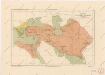
Říše Alexandra Velikého

Regiones inter Euphratem, Tigrim et Indum, India intra Gangem bor., Scythia extra Imaum, Serica
1 : 4250000 Asie západní Reichard, Christian Gottlieb Campius, D. a D. Campio
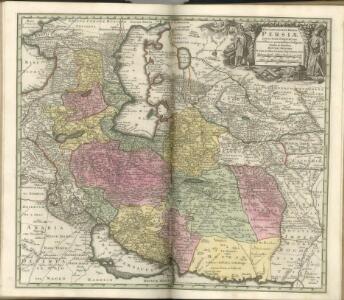
IMPERII PERSICI IN OMNES SUAS PROVINCIAS (tam veteribus quam modernis earundem nominibus Signatas) EXACTE DIVISI Nova Tabula Geographica
1 : 6700000 Asie střední Homann, Johann Baptist Io. Baptista Homann
Imperii Persici in omnes suas provincias (tam veteribus quam modernis earundem nominibus signatas) exacte divisi nova tabula geographica
1 : 6700000 Asie střední Homann, Johann Baptist Io. Baptista Homann
Imperii Persici in omnes suas provincias (tam veteribus quam modernis earundem nominibus signatas) exacte divisi nova tabula geographica
1 : 6700000 Asie střední Homann, Johann Baptist Io. Baptista Homann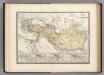
Empire d'Alexandre.
1 : 10000000 Levasseur, E.
Regiones inter Euphratem, Tigrim et Indum, India intra Gangem Bor., Scythia Extra Imaum, Serica
1 : 4500000 1 Karte : Kupferdruck ; 62 x 73 cm Reichard, Christian Gottlieb Theophil [Campius]
[Jran Turan, Persien, Afghanistan, Beludschistan, Turkestan]
Grosser Hand-Atlas über alle Theile der Erde in 170 Karten Meyer, J. Verlag des Bibliographischen Instituts