Maps of Black Sea Region


Oorlogskaart van Turkije, Zuid-Rusland en grenslanden
1 : 2250000 Annotatie: Westelijk deel van de kaart ontbreekt Amsterdam : Seyffardt
Mer Noire.
1 : 2600000 Garnier, F. A., 1803-1863
Pontos Euxeinos / ex conitabus geographicis Abrahami Ortelij
1 : 3750000 1 Karte : Kupferdruck ; 35 x 50 cm Ortelius, Abraham [Officina Plantiniana]
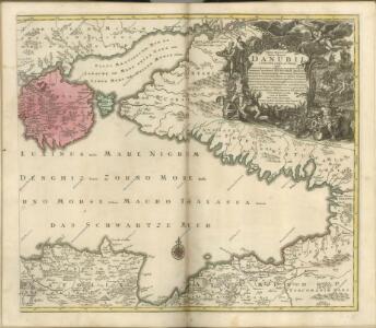
Charte des Schwarzen Meeres
1 Karte : Kupferdruck ; 40 x 55 cm Götze im Verlage des Industrie Comptoirs
Carte de la mer noire ou Kara Degniz
1 Karte : Kupferdruck ; 30 x 42 cm Mentelle; Tardieu s.n.
bez titulu: soubor panoramat – Krymská válka

Carte de la Mer Noire
1 : 7420000 2 Karten auf einem Blatt : Kupferdruck ; 22 x 17 cm (13 x 17 cm und 9 x 17 cm) Bellin, Jacques Nicolas [Bellin]
Pontus Euxinus of Niewe en naaukeurige paskaart van de Zwarte Zee
1 Karte : Kupferdruck ; 40 x 58 cm Renard; Witsen apud L. Renard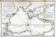
Carte réduite de la mer noire
1 Karte : Kupferdruck ; 52 x 80 cm Bellin; Croisey s.n.
Ice Chart Black Sea, November, December.
U.S. Navy
Ice Chart Black Sea, March, April.
U.S. Navy
Carte de la mer noire, d'Azof et de Marmora
1 : 1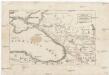
Uebersichts-Karte des russisch-türkischen Kriegsschauplatzes
Kavkaz-oblast Ludwig, J. von J. Ludwig und A. Zang
Theatre de la guerre dans la Petite Tartarie, la Crimée, la mer Noire, &c
1 Karte auf 2 Blatt : Kupferdruck ; 91 x 60 cm L'Isle chez Jean Cóvens et Corneille Mortier géographes
Theatre de la guerre dans la Petite Tartarie, la Crimée, la mer Noire, &c. / dressée sur un grand
1 : 1300000 1 Karte auf zwei Blatt : Kupferdruck ; 91 x 60 cm L'Isle, Guillaume de chez Jean Cóvens et Corneille Mortier géographes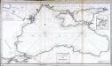
Carte réduite de la mer noire
1 Karte : Kupferdruck ; 51 x 92 cm Clerc; Dupuis Froullé
Die Haefen des Schwarzes Meeres an der asiatischen Küste
Asie západní Flemming
Russia on the Euxine (Black Sea).
1 : 3380000 Sharpe, J.
Karta Černago morja
Schwarzes Meer
Ice Chart Black Sea, January, February.
U.S. Navy
Black Sea, Index Chart for Ice Data Tables.
U.S. Navy
Karte des Maeotischen Sees und des Pontus Euxinus
1 : 5200000 Azovské moře-oblast (Ukrajina a Rusko) Barbié du Bocage, Jean Denis Anville, Jean-Baptiste Bourguinon d'
[Östl. Schwarzmeerküste]
1 : 1500000 Osmanisches Reich, Mingrelien
K dějstvījam Černomorskago flota i Dunajskoj flotilīi 1806 - 1812 gg.
Schwarzes Meer Seeschlacht
Tartaria in Europe / by Robt. Morden
1 : 11100000 1 Karte : Kupferdruck ; 11 x 13 cm Morden, Robert [Printed for Robert Morden and Thomas Cockerill]
Pontus Euxinus of Niewe en naaukeurige paskaart van de Zwarte Zee / uyt verscheydene stucken van die
1 : 2100000 1 Karte : Kupferdruck ; 40 x 58 cm Ottens, Reinier apud R. & I. Ottens
Geologičeskaja karta Evropejskoj Rossii
1 : 2500000 Südwest-Blatt Karpinskij, A.P. (Aleksandr Petrovič) Kartografičeskoe zavedenie A.Il'ina
Feuille 34 (F V), uit: Carte géologique internationale de l'Europe : la carte, votée au congrès géologique international de Bologne en 1881, est exécutée conformément aux décisions d'une commission internationale, avec le concours des gouvernements, sous le dir. de M.M. Beyrich et Hauchecorne
Annotatie: Blad 48 gamme des couleurs; blad 49: bladwijzer en titelblad Heinrich Ernst Beyrich 1815-1896; Wi. Hauchecorne Berlin : Reimer / (Berlin: Institut lithographique)
Charte der Laender am Caucasus
1 : 2100000 Kavkaz (pohoří : oblast) Reinecke, Johann Christoph Matthias