Maps of Zuid-Holland
18. Biesbosch, uit: Geologische kaart van Nederland / door W.C.H. Staring ; bew. aan de Topographische Inrichting
1 : 200000 Winand Carel Hugo Staring 1808-1877; Topographische Inrichting, 's-Gravenhage 's-Gravenhage : Belinfante
18. Biesbosch, uit: Geologische kaart van Nederland / door W.C.H. Staring ; bew. aan de Topographische Inrichting
1 : 200000 Winand Carel Hugo Staring 1808-1877; Topographische Inrichting, 's-Gravenhage 's-Gravenhage : Belinfante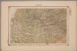
18. Biesbosch, uit: Geologische kaart van Nederland : schaal van 1:200.000 / door W.C.H. Staring ; uitgevoerd door het Topographisch Bureau van Oorlog ; uitgegeven op last van Zijne Majesteit Den Koning
Annotatie: Impressum ontleend aan omslag; Kaart "Nederland de dijken weggedacht" [kaart 25] en kaart 13 (bladwijzer) vermelden het jaar 1869; Kaart 'Limburg en de Hesbaije' (bladnr. 26) vermeldt het jaar 1868; Blad 5/9 ontbreekt Topographische Inrichting, 's-Gravenhage; Topographisch Bureau Haarlem : A.C. Kruseman
Land-kaart van Holland, een gedeelte van Batavie soo als het was 1612.
1 : 500000 [S.l.] : [s.n.]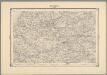
13, uit: Topografische atlas van het Koninkrijk der Nederlanden
Annotatie: Map met 19 losse krt. schaal 1:200.000 en 1 bladwijzer schaal 1:1.000.000 ['s-Gravenhage : Ministerie van Oorlog, Topografisch Bureau]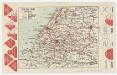
Zuid-Holland, uit: [Provinciale fietskaart ...]
Annotatie: Boven en onder het kaartbeeld verkeersborden voor wielrijders; Provincienaam op voorkant geflankeerd door provinciewapen en wapen van de provinciehoofdstad, waaronder een stadsbeeld met fietser in klederdracht; Kaart van Overijssel ontbreekt Deventer : Burgers E.N.R
[Kaart], uit: Kaart van Zuid-Holland : voor wandelaars, wielrijders en automobilisten / lith. J. Smulders
1 : 133000 J. Smulders & Co., 's-Gravenhage Bussum : Sleeswijk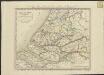
Hollande méridionale, divisée en arrondissemens et cantons de justice de paix
1 : 175000 dressée et gravée par C. van Baarsel et fils. A Amsterdam et a La Haye : chez F.J. Weygand ...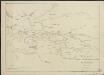
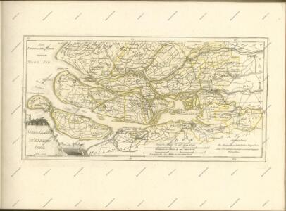
Kaart van den grooten Zuidhollandschen waard, zoo als die was voor de overstroomng door den St Elisabets Vloed in 't jaar 1421
1 : 100000 opgemaakt en geteekend door Jan Smits J.Z. Rotterdam : Mensing en van Westrenen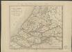
Hollande méridionale, divisée en arrondissemens et cantons de justice de paix
1 : 200000 dressée et gravée par C. van Baarsel et fils. À Amsterdam [etc.] : chez F.J. Weygand
Carte de la Hollande ou sont les envs. de Rotterdam, d'Hellevoetsluys, de Goerée, de Villemstat &c.
1 : 300000 gravé par Delahaye Lainé. [Paris] : par le sr. Robert géographe ordin. du roi
Hollandiae pars meridionalior, vulgo Zuyd-Holland / auctore Nic. Visscher
1 : 170000 Annotatie: Met privilege; Deze kaart is oorspronkelijk verschenen te Amsterdam bij Nic. Visscher tussen 1677 en 1702; Annotatie geografische gegevens: Met schaalstokken o.a. van Een Hollandtsche myle van 2000 Rhynlandtsche roeden [=6,4 cm]; West boven Petrus Schenk 1728-1803 [Amsterdam : nunc apud P. Schenk jun]
Novissima tabula insular. Dordracensis, Alblasser, Crimper, Clundert etc. : comprehendens item territoria Vianae, Goricomii, Leerdami, Altenae, Heusdenae, ac civitates S. Geertrudisbergam, Sevenbergam, Willemstadium, et circumjacentes regiones ad Holl. pertinentes
1 : 100000 auct. Balth. Florentio a Berckenrode. Amstelodami : sumptibus Henrici Hondii
Hollandiae Meridionalis pars I : continens novissimam Delflandiae, Schielandiae et circumjacentium insularum descriptionem
1 : 140000 IVDA [= Johan van den Aveele] Amstelaedami : ex typographia Gerardi Valk et Petri Schenk
Hollandiae meridionalis pars II : continens novissimam Insularum Dordracencis Alblasser, Crimper et Clundert, cum adjacentibus descriptionem
1 : 140000 Joh. van den Avele invenit & fecit. Amstelaedami : ex typographia Gerardi Valk et Petri Schenk
Delflandia, Schielandia, et Insulae trans Mosam illis obiacentes ut sunt Voorna, Overflackea, Goerea, Yselmonda, etc. [Karte], in: Novus Atlas, das ist, Weltbeschreibung, Bd. 1, S. 399.
1 Karte aus Atlas Blaeu, Joan Blaeu, Willem Janszoon
Hollandiae Pars Meridionalior
1 : 180000 Mollova mapová sbírka Visscher, Nicolaes Schenk, Peter II
Novißima Tabula Insular. Dordracensis, Alblasser, Crimper, Clundert etc: [...] [Karte], in: Gerardi Mercatoris et I. Hondii Newer Atlas, oder, Grosses Weltbuch, Bd. 1, S. 448.
1 Karte aus Atlas Mercator, Gerhard und Hondius, Jodocus Jansson, Jan
Novißima Tabula Insular. Dordracensis, Alblasser, Crimper, Clundert etc: [...] [Karte], in: Novus atlas absolutissimus, Bd. 3, S. 171.
1 Karte aus Atlas Janssonius Offizin
Hollandiae pars meridionalior, vulgo Zuyd-Holland
1 : 170000 auctore Nic. Visscher. [Amsterdam] : nunc apud P. Schenk jun.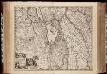
Hollandiae pars meridionalior, vulgo Zuyd-Holland / auctore Nic. Visscher
1 : 170000 Annotatie: Cum privilegio Ordinum Hollandiae et West-Frisiae; Origineel is Blad 51 in atlas factice; Annotatie geografische gegevens: West boven; Met twee schaalstokken Nicolaes Jansz. Visscher jr. 1649-1702 [Amsterdam : Nicolaes Visscher]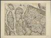
Delflandia, Schielandia, et insulae trans Mosam illis objacentes ut sunt Voorna, Overflackea, Goerea, Yselmonda, etc
1 : 130000 exc. Guilj. Blaeuw. [Amsterdam] : Guilj. Blaeuw
[101][102] Nova atque emendata descriptio Suydt Hollandiae, uit: Atlas sive Descriptio terrarum orbis
Annotatie: Gedigitaliseerde versie. Amsterdam. Heiloo : Picturae (vervaardiger), 2015. tiff-bestand. Gedigitaliseerd: 07-01-2015; Origineel: Universiteitsbibliotheek Vrije Universiteit (XL.05127.-) ; Netherlands; Titelpagina ontbreekt Wit, Frederik de Amsterdam : Frederick de Wit

DELFLANDIA, | SCHIELANDIA, | et Insulæ trans Mosam | illis objacentes ut sunt | VOORNA, OVERFLACKEA, | GOEREA, YSELMONDA, etc.
Exc. Guilj. Blaeuw.
[Recto], uit: Delflandia, Schielandia, et insulae trans Mosam illis objacentes ut sunt Voorna, Overflackea, Goerea, Yselmonda, etc. / [Willem Jansz. Blaeu]
1 : 130000 Annotatie: Oorspr. verschenen in: Appendix Theatri A. Ortelii et Atlantis G. Mercatoris ... - Amsterdami : apud Guiljelmum Blaeu, 1631; Bestaat uit twee aan elkaar gemonteerde kaartdelen, afkomstig van twee afzonderlijke afdrukken van de kaart. Bij de rechterhelft ontbreekt op de achterzijde de tekst; Annotatie geografische gegevens: Noordwest boven Blaeu, Willem Jansz. [Amsterdam : exc. Guilj. Blaeuw]
[100][103] Novissima Delflandiae, Schielandiae ..., uit: Atlas sive Descriptio terrarum orbis
Annotatie: Gedigitaliseerde versie. Amsterdam. Heiloo : Picturae (vervaardiger), 2015. tiff-bestand. Gedigitaliseerd: 07-01-2015; Origineel: Universiteitsbibliotheek Vrije Universiteit (XL.05127.-) ; Netherlands; Titelpagina ontbreekt Wit, Frederik de Amsterdam : Frederick de Wit
Novissima tabula insular. Dordracensis, Alblasser, Crimper, Clundert etc. comprehendens item territoria Vianæ, Goricomii, Leerdami, Altenæ, Heusdenæ, ac civitat. S. Geertrudisbergam, Sevenbergam, Willemstadium, et circumjacentes regiones ad Holl. pertinentes
1 : 360000 [Balthasar Florisz. van Berckenrode] Amstelodami : sumptibus Henrici Hondii.