Maps of Ciudad Real

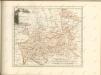
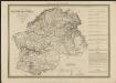
Provincia de la Mancha donde se comprehenden los partidos de Ciudad-Real, Infantes, y Alcaràz
1 Karte : Kupferdruck ; 36 x 37 cm López s.n.
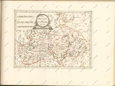
Provincia de la Mancha donde se comprehenden los partidos de Ciudad-Real, Infantes, y Alcaràz
1 : 500000 compuesta sobre las mejores memorias impresas y manuscritas, y sujeta à las observaciones astronomicas por D. Thomàs Lopez, pensionista de S. M. Madrid : [Thomas Lopez]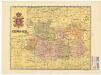
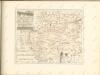
Ciudad-Real
Ed. Alberto Martín; F. Galceran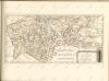
Cataluña con las nuevas divisiones
1 : 600000 formada por A. H. Dufour Paris : Bulla
[Carte d'Espagne et de Portugal en neuf feuilles, 5]
1 Blatt : 31 x 41 cm P.G. Chanlaire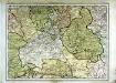
Espagne et Portugal, 5
1 Blatt : 31 x 42 cm Mentelle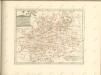

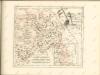
Castiliæ novæ pars occidentalis provincias Madrit, Toledo et Mancha comprehendens
1 Karte : Kupferdruck ; 48 x 46 cm Güssefeld; López apud Homannianos Heredes
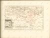
Castiliæ novæ pars orientalis provincias Cuenca et Guadalaxara comprehendens
1 Karte : Kupferdruck ; 51 x 43 cm Güssefeld; López apud Homannianos Heredes
A map of old & new Castile
1 : 1100000 Kastilie (Španělsko) Mendes Silva, Rodrigo Ioh. Senex
Castilla la Nueva con las nuevas divisiones
1 Mapa. Atlas Nacional de España Dufour, A.H. 0
Regnorum Castellæ veteris Legionis et Gallæciæ principatuumque Biscaiæ et Asturiarum accuratissima descriptio, 5
1 Blatt : 54 x 41 cm Visscher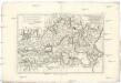
Castille Nouvelle, et r. de Valence
1 : 7660000 Kastilie (Španělsko) Bonne, Rigobert André
Spain, Portugal 3.
1 : 1774080 Letts, Son & Co.
La Castille vieille et nouvelle avec l'Estremadure
1 Karte : Kupferdruck ; 44 x 53 cm Nolin; Rousseau; Silva; Julien chez le Sr. Julien a l'hotel de soubise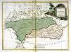
Andalusia et Granada
1 Karte : Kupferdruck ; 28 x 38 cm Zatta presso Antonio Zatta
Regnum Castellæ novæ, Andalusiæ, Granadæ, et Algarbiæ, nec non maxime partis Portugalliæ, et Extremaduræ
1 Karte : Kupferdruck ; 45 x 55 cm Danckerts Justus Danckerts
[Spanien und Portugal, Blatt 3]
Adolf Stieler's Handatlas über alle Theile der Erde und über das Weltgebäude Stieler, Adolf Justus Perthes
Spanien, Portugal SW.
1 : 1800000 Berghaus, Heinrich; Flemming, Carl; Sohr, Karl; Theinert, A.
Neueste Generalkarte von Portugal und Spanien, 5
1 Blatt : 70 x 50 cm Schrämbl
Andaluziae Nova Descript. [Karte], in: Gerardi Mercatoris et I. Hondii Newer Atlas, oder, Grosses Weltbuch, Bd. 2, S. 204.
1 Karte aus Atlas Mercator, Gerhard und Hondius, Jodocus Jansson, Jan
Andaluzia
1 Karte : Kupferdruck ; 17 x 24 cm Mercator; Keere Cloppenburgh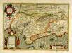
Andaluziæ nova descript
1 Karte : Kupferdruck ; 34 x 49 cm Mercator; Hondius; Hondius Henricus Hondius
Andaluziæ nova descript
1 Karte : Kupferdruck ; 34 x 49 cm Hondius; Mercator Jodocus Hondius