Maps of Turan Lowland


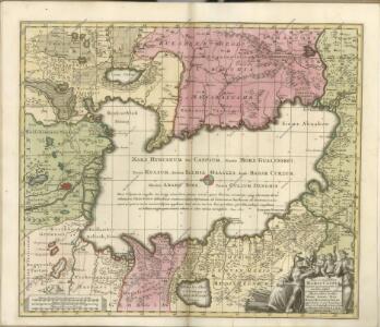
Nova ac verissima Maris Caspii ante hac maximam fere partem nobis incognita ac regionum adjacentium delineatio : jussu invictissimi principis Petri Alexii fil. magni Russorum imperatoris
1 : 1500000 immenso labore et maximis sumptibus facta, atque ex autographo in lucem edita per Reinerum Ottens geographum Amstelaedam. Iacob Keyser sculp. Gedrukt t'Amsterdam : by de Wed. I. Ottens op de Nieuwen Dyk in de Wereldkaart
Nova et accuratissima maris Caspii hactenus maximam partem nobis non satis cogniti ac regionum adjacentium delineat
1 Karte : Kupferdruck ; 48 x 56 cm Probst; Seutter anjezo in Verlag bey Iohann Michael Probst Chalcogr. in Augspurg
Tiefländer
Atlas der Geologie Zittel, K.v. ; Berghaus, Hermann Justus Perthes
Tabula Asiae III. [Karte], in: Claud. Ptolemaeus. Geographia lat. cum mappis [...], S. 302.
1 Karte aus Atlas Münster, Sebastian [und Ptolemaeus, Claudius]
Vierte Revolution des Caspischen Meeres, oder Karte des Czar Peter des Grossen
1 Karte : Kupferdruck ; 20 x 29 cm Anville Philipp Heinrich Perrenon
Otčetnaja karta Turkmenīi
Turkmenistan Eroberung
Carte des pays voisins de la Mer Caspiene / dressée pour l'usage du roy sur la carte de cette mer f
1 : 3100000 1 Karte : Kupferdruck ; 44 x 59 cm L'Isle, Guillaume de chez Jean Cóvens et Corneille Mortier geographes
The Caspian Sea.
1 : 2900000 Arrowsmith, John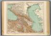
73-74. Caucasia, Mar Caspio.
1 : 3000000 Touring club italiano
Russia 9.
1 : 3421400 Letts, Son & Co.
Russia in Europe Part IX and Georgia.
1 : 3500000 Society for the Diffusion of Useful Knowledge (Great Britain)
Russia in Europe part IX and Georgia / published under the superintendence of the Society for the Di
1 : 3500000 1 Karte : Kupferdruck ; 31 x 38 cm Walker, John by Baldwin and Cradock
Uebersichts Karte der russischen Provinzen nördlich und südlich vom Kaukasus
1 : 2900000 1 Karte : Kupferdruck ; 42 x 47 cm in der literarisch artistischen Anstalt
Uebersichts Karte der russischen Provinzen nördlich und südlich vom Kaukasus
1 : 2900000 Kavkaz (pohoří : oblast) Literarisch artistische Anstalt
Uebersichts Karte der Russischen Provinzen nördlich und südlich vom Kaukasus
1 : 2500000 München : in der literarisch artistischen Anstalt
28-29. Uzbek SSR and Turkmen SSR. The World Atlas.
1 : 3000000 USSR (Union of Soviet Socialist Republics).
Pays du Caucase
Nouvel atlas physique politique et historique de l'Empire ottoman et des états limitrophes en Europe, en Asie et en Afrique, en quarante feuilles Hellert, J.J. Bellizard, Dufour et Cie
Nova et accuratissima maris Caspii hactenus maximam partem nobis non satis cogniti ac regionum adjac
1 : 2100000 1 Karte : Kupferdruck ; 48 x 56 cm Seutter, Matthäus [Seutter]
Nova et accuratissima maris Caspii hactenus maximam partem nobis non satis cogniti ac regionum adjac
1 : 2100000 1 Karte : Kupferdruck ; 48 x 56 cm [Seutter]
Höhenschichtenkarte der Kaukasusländer mit Reiserouten Dr. G. Raddes
1 : 4500000 Radde, Gustav Engelmann
Russia at the Caucasus.
1 : 3380000 Sharpe, J.
Charte der Laender am Caucasus
1 : 2200000 Kavkaz-oblast Reinecke, Johann Christoph Matthias
Charte der Laender am Caucasus
1 : 2200000 Kavkaz-oblast Reinecke, Johann Christoph Matthias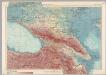
U.S.S.R. - Caucasia. Pergamon World Atlas.
1 : 2500000 Polish Army Topography Service
Die Volker des Kaukasus U.S.W.
1 : 3000000 Berghaus, Heinrich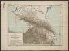
Karte für die Niederschlagsverhältnisse und die Verbreitung der wichtigsten Holzgewächse in den Kaukasusländern
1 : 4500000 Radde, Gustav Engelmann
Karta Kavkaza dlja pojasnenija vojennych dějstvij ot načala 1838go goda po konec 1842 goda
Kavkaz-oblast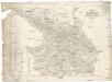
Karte des Kaukasus
Kavkaz-oblast Mahlmann, H. bei F.H. Morin