Maps of Niestetal
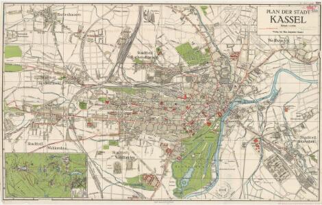
Plan der stadt Kassel

Plan der Haupt-Stadt Cassel
1 : 8000 im Jahr 1819 aufgenommen durch F. W. Schirmer [S.l.] : [s.n.]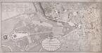
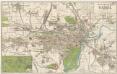
Plan der Kurhessischen Haupt und Residenzstadt Cassel
Selig, F. W.; Bürck, A.
Kassel

PLAN der Königl. Westphälischen Haupt und Residenzstadt CASSEL
Kassel (Německo)
Uebersicht der nicht geschlossenen Gewässer des Regierungsbezirks Cassel und deren Schonzeiten
Kassel (Německo) Wenderoth, Georg
Plan von Wilhelmshöhe mit denen daselbst befindlichen Anlagen und Gebäuden
Weise, Gotthelf Wilhelm
Plan von Weissenstein mit allen daselbst befindlichen Anlagen u. Gebäuden
Susemihl, Johann Conrad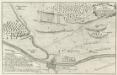
Plan der Action welche zwischen denen Französischen und Hessischen Trouppen d: 23 Jul: 1758 ohnweit Cassel bey Hof- Ellenbach vorgefallen
Mollova mapová sbírka
Plan du siege de Cassel, avec les travaux et les tranchées des alliés devant cette place, commande par S. A. S. Monseigneur Le Prince Frederic Auguste Duc de Brunswic et de Luneburg, ... depuis le 18. d'Aout jusqu'au 1. Novembre 1762 où la place se [...]
1 : 22000 ... levé par H.D. Gerlach lieutenant du Genie gravé sous la direction de J. v. Schley
Meßtischblatt 2664 : Cassel (West), 1909
1 : 250000 Cassel (West). - Aufn. 1907. - 1:25000. - [Berlin]: Reichsamt für Landesaufnahme, 1909. - 1 Kt.
Meßtischblatt 2665 : Kassel (Ost), 1927
1 : 250000 Kassel (Ost). - Hrsg. 1909, einz. Nachtr. 1927. - 1:25000. - [Berlin]: Reichsamt für Landesaufnahme, 1927. - 1 Kt.
Meßtischblatt 2665 : Cassel (Ost), 1909
1 : 250000 Cassel (Ost). - Aufn. 1907. - 1:25000. - [Berlin]: Reichsamt für Landesaufnahme, 1909. - 1 Kt.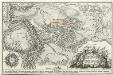
Plan der Action welche zwischen denen Französischen u. Allirten Trouppen den 10. Octobr. 1758 bey Landwerhagen ohn weit Cassel gefallen
Mollova mapová sbírka Fridrich, Jacob Andreas Fridrich, Jacob Andreas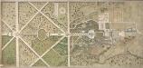
General Plan Des Fürstl. Lustgartens auf Weisenstein bey Cassel
Müller, J. P.
Plan du Siege de Cassel, avec les Travaux et les Tranchées des Alliés devant cette Place
1 : 20000 Mollova mapová sbírka Gerlach, H. D. Schley, Jacobus van der Gosse, Pierre II.
Plan de la Bataille de Wilhelmsthal
1 : 55000 Mollova mapová sbírka Bauer, Friedrich Wilhelm von Schley, Jacobus van der Gosse, Pierre II.
Tableau Topographique Qui comprend la Partie Septentrionale du Landgraviat de Hesse Cassel et de la Principauté de Waldeck, l'Eveché de Paderborn, Partie du Comté de Grubenhague et les Frontieres de ces Etats]
1 : 130000 Mollova mapová sbírka Julien, Roch-Joseph Julien, Roch Joseph

[Fritzlar] / hrsg. von der kgl. geologischen Landesanstalt in Berlin ; geognostisch bearb. von F. Beyschlag ... [et al.] 1888-1889
1 : 80000 Annotatie geografische gegevens: Legenda rechts van de kaart Franz Heinrich August Beyschlag 1856-1915; Kgl. geologische Landesanstalt, Berlin [Berlin : Verlag der Simon Schropp'schen Hof-Landkartenhandlung (J.H. Neumann)]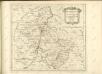

Landgraviatus Hassiae Inferioris Comitatvs Waldeciae Eichsfeldiae Tabvla Geographica
1 : 140000 Mollova mapová sbírka Berger, Daniel
Le Landgraviat de Hesse-Cassel Meridional et Septentr: avec une Partie du Landgraviat de Hesse-Darmstat et de la Vetteravie avec autres dependences
1 : 200000 Mollova mapová sbírka Carlet, Louis-François Lotter, Tobias Conrad
Landgrafiatvs Hasso-Cassellanvs typo geographico quatuor Foliorum expressus Cura Homannianorum Heredum Norimb: 1761
1 : 160000 Mollova mapová sbírka Homann, Johann Baptist Homann, Johann Baptista - dědici
Delineatio Geographica generalis comprehendens VI. Foliis Singulos Principatvs Comitatvs Ditiones Dynastias omnes quotquot Imperio Serenissimi Principis Landgrafii Hasso-Darmstadiensis subsunt :
1 : 180000 Mollova mapová sbírka Bronner, Christian Maximilian Homann, Johann Baptista - dědici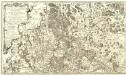
Carte Demi-Topo-Graphique De La Partie Septentrionale du Landgraviat de Hesse-Cassel
1 : 190000 Mollova mapová sbírka Carlet, Louis-François Beaurain, Jean de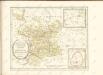

Cassel 72, uit: [W. Liebenow's Special-Karte von Mittel-Europa]
1 : 300000 titelvariant: W. Liebenow's Mittel-Europa; Annotatie: Titel boven de bladen: W. Liebenow's Mittel-Europa Johannes Wilhelm Liebenow 1822-1897 Hannover : Hermann Oppermann
Cassel-Göttingen 72, uit: Special-Karte von Mittel-Europa / nach amtlichen Quellen bearbeitet von W. Liebenow
1 : 300000 titelvariant: W. Liebenow's Mittel-Europa; Annotatie: Titel boven de bladen: W. Liebenow's Mittel-Europa Johannes Wilhelm Liebenow 1822-1897 Frankfurt a. M. : Ludwig Ravenstein