Maps of Kjølen Mountains

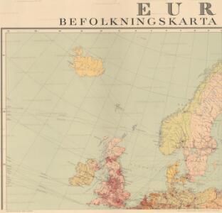
Europa befolkningskarta

Statistikk 38: Bosettingskart over Norge. Oversiktskart
Statistisk Sentralbyrå
Evropa, 1
1 Blatt : mehrfarbig ; 49 x 57 cm Homännische Erben
Septentrionalium regionum descriptio
1 : 28000000 1 Karte : Kupferdruck ; 8 x 11 cm Galle, Philippe [Christophe Plantin]
Septentrionalivm regionvm descrip
1 : 11050000 Evropa severozápadní
Septentrionalium Regionum Descrip. [Karte], in: Theatrum orbis terrarum, S. 286.
1 Karte aus Atlas Ortelius, Abraham
Septentrionales Regiones XVIII. No. Tab. [Karte], in: Claud. Ptolemaeus. Geographia lat. cum mappis [...], S. 410.
1 Karte aus Atlas Münster, Sebastian [und Ptolemaeus, Claudius]
Tabula Moderna Norbegie Et Gottie. [Karte], in: Claudii Ptolemei viri Alexandrini mathematice discipline philosophi doctissimi geographie opus [...], S. 251.
1 Karte aus Atlas Waldseemüller, Martin [und Ptolemaeus, Claudius] Übelin, Georg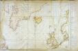
Carte réduite des mers du Nord
1 Karte : Kupferdruck ; 54 x 76 cm Verdun de la Crenne; Borda; Pingré; Petit s.n.
Swedland and Norway.
from A new systeme of the mathematicks: containing I. Arithmetick, as well natural and decimal, as in species, or the principles of algebra. II. Practical geometry, together with the first six books of Euclid's Elements, as also the eleventh and twelfth, symbo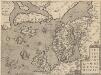
Septentrionallium Regionum Descrip. [Karte], in: Theatrum orbis terrarum, S. 381.
1 Karte aus Atlas Ortelius, Abraham Vrients, Jan Baptista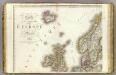
Europe 1.
1 : 3850000 Brue, Adrien Hubert, 1786-1832
Scandinavien und Polen, kirchlichen Eintheilung bis zur Reformation.
1 : 9400000 Spruner von Merz, Karl
Tabula Moderna Prussie Livonie Norbegie Et Gottie. [Karte], in: [Clavdii Ptholomei Cosmographi ...], S. 263.
1 Karte aus Atlas Nicolaus Germanus [und Ptolemaeus, Claudius]
Dänemark, Jsland u. Färöer, Schweden und Norwegen
Stieler's Hand-Atlas Stieler, Adolf bei Justus Perthes
Dänemark, Island u Färöer, Schweden und Norwegen
Hand-Atlas über alle Theile der Erde nach dem neuesten Zustande und über das Weltgebäude Stieler, Adolf bei Justus Perthes
Praktische Geschäfts und Reisekarte sämmtlicher Staaten von Europa enthaltend die vorzüglichsten Strassen-Verbindungen mit Angage der Distanzen und der bestehenden Eisenbahnen: Nebst einem Theile von Africa u. Asien, und zwar die Länder: Marocco, Algerien u. Tunis, ganz Kleinasien, und ein Theil von Persien
Schulz, R. A.
Chart shewing the track of His Majesty's sloops Racehorse and Carcass during the expedition towards the north pole 1773
1 Karte : Kupferdruck ; 43 x 20 cm Palmer s.n.
Vorstellvng der Sonnen- oder Erd, Finsternis den 25. Jul. 1748
Mollova mapová sbírka Lowitz, Georg Moriz Dorn, Sebastian Homann, Johann Baptista - dědici
De custen van Noorwegen, Finmarken, Laplandt, Spitsbergen, Ian Maÿen Eÿlandt, Yslandt, als mede Hitlandt, en een gedeelte van Schotlandt
1 Karte : Kupferdruck ; 44 x 54 cm Doncker bÿ Hendrick Doncker boeckverkoper in de Nieubrugsteeg
Karte von Europa, 1
4 Blätter : 53 x 70 cm Verlag der Königlich-Preussischen Academie-Kunst- und Buchhandlung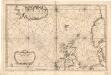
Museumskart 155: Carte Réduite De Partie De La Mer Du Nord
1 : 3000000 S. Bellin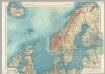
Northern Europe. Pergamon World Atlas.
1 : 5000000 Polish Army Topography Service
Western part of the northern states including the British Islands Norway Denmark and part of Sweden
1 Blatt : 53 x 68 cm Sayer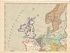
Evropa XIX. století: od vídeňského kongresu r. 1815, do rozhodnutí na frontách světové války r. 1918
Kašpar, Jan
[Ethnographische Karte von Europa]
Zweiter Band, enthaltend in vier Abtheilungen die Vertheilung der Organismen: 5. Pflanzen-Geographie, 6. Thier-Geographie, 7. Anthropographie, 8. Ethnographie Humboldt, Alexander von Verlag von Justus Perthes
Schweden, Norwegen, Daenemark.
1 : 4000000 Ziegler, J. M.
North Sea, Baltic cables, wireless stations.
1 : 12500000 Philip, George
Schweden Daenemarck u. Norwegen
Dánsko Mollo, Tranquillo Tranquillo Mollo