Maps of Osrednjeslovenska

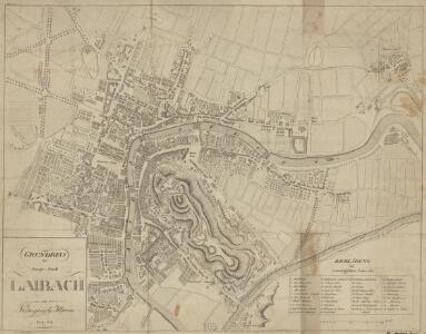
Grundriss der Haupt-Stadt Laibach im Königreiche Illyrien
Deschmann, Franz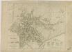
Grundriss der Haupt-Stadt Laibach

Plan der Stadt Laibach

Laibach

Laibach
1 : 75000 Ljubljana
Weixelburg und Zirknitz.
from Spezialkarte der osterreichisch-ungarischen Monarchie.
Yugoslavia 1:100,000, Ljubljana
Yugoslavia 1:100,000 , Series GSGS 4396. Great Britain. War Office. [London] : War Office
Laibach.
from Spezialkarte der osterreichisch-ungarischen Monarchie.
Ducatus Carnioliae Tabula Chorographica Iusu Sumptuque inclytorum Provinciae Statuum.
1 : 100000 Mollova mapová sbírka Florjančič de Grienfeld, Janez Dizma
Ljubljana
1 : 200000 Lublaň (Slovinsko : oblast) Kartografska radionica
Neueste special Karte des Cillier Kreises im Herzogthume Steyermark
1 : 210000 Celje (Slovinsko) Kaiser, Joseph Franz Jos. Fr. Kaiser
Neueste special Karte des Cillier Kreises im Herzogthume Steyermark
1 : 210000 Štýrsko (Rakousko) Kaiser, Jos. Fr. Jos. Fr. Kaiser
Neueste special Karte des Cillier Kreises im Herzogthume Steyermark
1 : 220000 Celje (Slovinsko) Kaiser, Joseph Franz Jos. Fr. Kaiser
Naseljenost prebivalstva na Kranjskem
1 : 400000 Kraňsko Lončar, Dragotin Kaisvinkler, Bohumil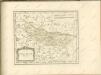

Übersicht der Krainer Metulum-Hypothesen
1 : 750000 Kroatien Ogulin (Region) Illyrien Augustus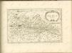

Unter Krain
1 : 500000 Unterkrain
Die slovenischen Mundarten
Drau-Gebiet Slowenisch, Mundart
Dioecesan-Carte von Laibach
1 : 260000 Lublaň-oblast (Slovinsko) Mascon, Johann Wolf, Anton Alojzij Johann Mascon
Aus der Übersichtskarte von Mittel-Europa 1:750 000
1 : 750000 Evropa střední K. k. Österreichische Staatsbahnen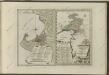

Generalkarte von Zentraleuropa

Der südliche Theil von Untersteyermark oder der Cillier Kreis
1 : 260000 Celje (Slovinsko) Kindermann, Joseph Karl Junker, Christoph Franz Xaver Miller
G. Freytags Karte der Isonzo-Front
1 : 350000 Gorizia (Itálie : provincie) Kartogr. Anstalt G. Freytag & Berndt
Istria, olim Lapidia. [Karte], in: Novus atlas absolutissimus, Bd. 5, S. 65.
1 Karte aus Atlas Janssonius Offizin
Karte vom Herzogthum Krain
1 : 290000 Kraňsko Loschan, Gottfried Stein, Carl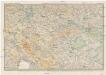
Karte des Krainisch-Kroatischen Gebirgslandes
1 : 250000 Chorvatsko Ravenstein, Ludwig Ludwig Ravenstein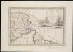
Lo Stato Veneto da terra diviso nelle sue provincie, seconda parte che comprede porzioni del Dogado del Trevisano del Friuli e dell' Istria
1 : 475200