Maps of British Isles

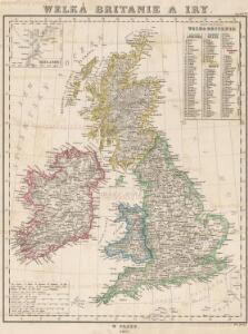
Welká Britanie a Iry

Welká Britanie a Iry
1 : 3400000 Irsko Merklas, Václav W. Merklas
British Isles (outline)
1 : 4500000 Patteson, Edward
British Isles.
1 : 4500000 Patteson, Edward

Grossbritanien.
1 : 3900000 Haller von Hallerstein, Friedrich; Reichard, C. G.
Isles Britanniques.
1 : 2600000 Jouvet et Cie.
British Isles.
1 : 3651000 Fisher, Richard Swainson
British Empire.
1 : 3200000 Lavoisne, M.
The British Isles. (with) inset map of the Shetland Islands.
1 : 3801600 Tallis, J. & F.
Great Britain, Ireland.
1 : 5500000 Huntington, Nathaniel G. (Nathaniel Gilbert), 1785-1848
British Isles.
1 : 6200000 Worcester, Joseph E.
Tabula novissima accuratissima regnorum Angliæ, Scotiæ Hiberniæ
1 Karte : Kupferdruck ; 56 x 48 cm Lotter Tobias Konrad Lotter
Tabula novissima accuratissima regnorum Angliæ, Scotiæ Hiberniæ
1 Karte : Kupferdruck ; 57 x 48 cm Seutter Matthäus Seutter
Carte du gouvernement militaire d'Angleterre
1 Karte : Kupferdruck ; 16 x 15 cm, Bildgrösse 35 x 46 cm Châtelain s.n.
Nouvelle carte pour introduire a la geographie et a la genealogie des rois d'Angleterre et d'Ecosse
4 Karten auf 2 Blättern : Kupferdruck ; Bildgrösse 38 x 92 cm Châtelain s.n.
Insvlarvm britannicarvm acurata delineatio
1 Karte : Kupferdruck ; 37 x 49 cm Ortelius; Janssonius; Keere apud Ioannem Ianssonium
Britische Inseln
Volksschul-Atlas über alle Teile der Erde Lange, Henry Druck und Verlag von Georg Westermann
British Islands.
1 : 4000000 Schonberg & Co.
Die Britischen Inseln nach ihrer kirchlichen Eintheilung bis zur Reformation.
1 : 3000000 Spruner von Merz, Karl
Novissima prae caeteris aliis accuratissima regnorum Angliae, Scotiae Hiberniaeq[ue] tabula
1 : 1850000 Irsko Wit, Frederick de F de Wit
Stereographical map, British Isles.
1 : 1600000 Stanford, Edward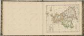

British Isles.
1 : 2500000 Andree, Richard; Times (London, England)
Grossbritannien u. Irland.
1 : 2500000 Stein, Christ. Gottfr. Dan.
Atlas für Handel und Industrie: Für Kaufleute, Fabrikante u. Gewerbetreibende, Handlungs- u. Gewerbe-Schulen

Britannicæ insulæ
1 Karte : Kupferdruck ; 39 x 51 cm Sanson; Robert de Vaugondy chés le Sr. Robert geog. ord. du roy quay de l'horloge du Palais
British Islands.
1 : 2300000 Morse, Jedidiah; Morse, Sidney E. (Sidney Edwards), 1794-1871
British Isles (Political).
1 : 1900000 Johnston, W. & A.K.