Maps of Africa

Index chart of hydropac messages / Under the authority of the Secretary of the Navy [by the] Hydrographic Office
Hydrographic Office Washington D.C. Washington D.C. : Hydrographic Office
Mountain Chains in Asia & Europe
The physical atlas Johnston, Alexander Keith William Blackwood & Sons
Die den Alten bekannte Welt
Historisch-genealogisch-geographischer Atlas von Le Sage Las Cases, Emmanuel Auguste Dieudonné Marius Joseph de Johann Velten, Kunsthändler
Tabv Gran Rvssie / diefert sitvs orbis hydrographorvm ab eo qvem Ptolomevs posvit
1 : 39000000 1 Karte : Holzschnitt ; 28 x 45 cm Ptolemaeus, Claudius [Lorenz Fries]
Asia
Schul-Atlas über alle Theile der Erde nach dem neuesten Zustande, und über das Weltgebäude Stieler, Adolf bei Justus Perthes
[Asien, Politische Übersicht]
E. von Sydow's Schul-Atlas in sechs und dreissig Karten Sydow, Emil von bei Justus Perthes
Indischer Ocean
E. von Sydow's Schul-Atlas in sechs und dreissig Karten Sydow, Emil von bei Justus Perthes
Resource-Relief Maps of: Europe and Australia.
Hammond, C.S.
Asiae noviter delineata [Karte], in: Le théâtre du monde, ou, Nouvel atlas contenant les chartes et descriptions de tous les païs de la terre, Bd. 2, S. 236.
1 Karte aus Atlas Blaeu, Willem Janszoon und Blaeu, Joan Blaeu, Willem Janszoon
Asien
Neuer Handatlas über alle Theile der Erde Kiepert, Heinrich Verlag von Dietrich Reimer
Walker's Geographical Pastime.
1 : 48000000 Walker, John
Asien
1 : 33633000 gezeichnet von H. Kiepert gestochen von W. Weiler Weimar : Geographisches Institut
Westliche Halbkugel.
1 : 100000000 Flemming, Carl
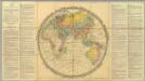
OEstliche Halbkugel
Afrika

Verbreitung der vorzuglicheren Saugethiere der Alten Welt.
1 : 50000000 Berghaus, Heinrich
[Bergketten in Asien und Europa]
Erster Band, enthaltend in vier Abtheilungen die Erscheinungen der anorganischen Natur: 1. Meteorologie und Klimatographie. 2. Hydrologie und Hydrographie. 3. Geologie. 4. Tellurischer Magnetismus Humboldt, Alexander von Verlag von Justus Perthes
Geographische Verbreitung.
1 : 108000000 Berghaus, Heinrich
America
1 : 40000000 Amerika Schmidt, Johann Marius Friedrich T. Mollo
Asia
Schul-Atlas über alle Theile der Erde nach dem neuesten Zustande, und über das Weltgebäude Stieler, Adolf Justus Perthes
[Asien, Oro-hydrographische Uebersicht]
E. von Sydow's Schul-Atlas in sechs und dreissig Karten Sydow, Emil von bei Justus Perthes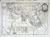
Carte pour servir a l'histoire philosophique et politique des etablissemens et du commerce des Europeens dans les deux Indes
1 Karte : Kupferdruck ; 30 x 45 cm Bonne s.n.
Asien
Adolf Stieler's Handatlas über alle Theile der Erde und über das Weltgebäude Stieler, Adolf Justus Perthes
Orbis veteribus notus
1 : 92500000 Afrika Meyer, Joseph Bibliographisches Institut
Asien und Europa
Atlas der Geologie Zittel, K.v. ; Berghaus, Hermann Justus Perthes
Wýchodnj polokaule
Afrika Merklas, Václav
Wýchodnj polokaule
Afrika Merklas, Václav
Wýchodnj polokaule
Afrika Merklas, Václav
Westliche Halbkugel
Amerika
![Index chart of hydropac messages / Under the authority of the Secretary of the Navy [by the] Hydrographic Office](https://images-2.georeferencer.com/images/iiif/776626277277/full/,300/0/native.jpg)

