Maps of Malay Archipelago

Kaart van den Nederlandsch-Indischen Archipel / bewerkt door C.M. Kan
[Amsterdam : J.L. Beijers]
Overzichtskaart van den Nederlandsch Oost Indischen Archipel / [J.W. Stemfoort en J.J. ten Siethoff ; gereproduceerd op last van het Departement van Koloniën, aan de Topographische Inrichting te 's-Gravenhage, onder leiding van den Directeur C.A. Eckstein]
Ministerie van Koloniën Den Haag s-Gravenhage : Departement van Koloniën
Algemeene kaart van Nederlands Oostindie : op de schaal van 1:5.000.000 ontworpen naar de beste kaarten en bronnen / geteekend door W. Beyerinck, J.M. Bruyn en J.F.W.A. Essers, Kadetten bestemd voor de dienst in de Oostindiën ; gelithographeerd by de Koninklijke Militaire Akademie door F.J. Ensink
[Den Haag : Ministerie van Koloniën]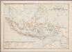
1. Overzichtskaart van den Nederlandsch Oost Indischen Archipel, uit: Atlas van Nederlandsch Oost-Indië / samengest. door Topographisch Bureau te Batavia van 1897-1904
Annotatie: Omgewerkte versie van: Atlas der Nederlandsche bezittingen in Oost-Indië / naar de nieuste bronnen samengest. door J.W. Stemfoort en J.J. ten Siethoff. - 's-Gravenhage : Topographische Inrichting, [ca. 1885] Topographisch Bureau, Batavia 's-Gravenhage : Topographische Inrichting
Dutch Possessions, in the Indian Archipelago.
1 : 13305600 Fullarton, A. & Co.
Neueste Karte der Ostindischen Inseln
Grosser Hand-Atlas über alle Theile der Erde in 170 Karten Meyer, J. Verlag des Bibliographischen Instituts
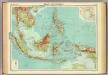
128-129. Indonesia. The World Atlas.
1 : 7500000 USSR (Union of Soviet Socialist Republics).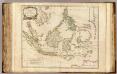
Indes Orientales.
1 : 8400000 Robert de Vaugondy, Gilles, 1688-1766
Die Ostindischen Inseln
Hand-Atlas über alle Theile der Erde nach dem neuesten Zustande und über das Weltgebäude Stieler, Adolf bei Justus Perthes
Die Ostindischen Inseln
Handatlas über alle Theile der Erde und über das Weltgebäude Stieler, Adolf Justus Perthes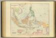
Asiatic Archipelago.
1 : 94000000 Stanford, Edward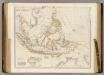
Asiatic Archipelago.
1 : 9500000 Arrowsmith, John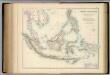
Indian Archipelago.
1 : 9187200 Fullarton, A. & Co.
Kaart van den Oost Indischen Archipel. Verzamelingsblad
Grav. en druk v. T. Hooiberg te Leiden te 's Hage : uitgave van K. Fuhri
Ostindischen Inseln.
1 : 14700000 Radefeld, Carl Christian Franz, 1788-1874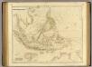
Asiatic Archipelago.
1 : 9500000 Arrowsmith, John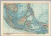
South-East Asia. Pergamon World Atlas.
1 : 10000000 Polish Army Topography Service
Kaart der Nederlandsche bezittingen in Oost-Indiën / door Js. van den Bosch ; gegraveerd door C. van Baarsel en Zoon
C. van Baarsel en Zoon s-Gravenhage ; Amsterdam : Gebroeders van Cleef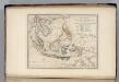
Islands of the East Indies.
1 : 23000000 Carey, Mathew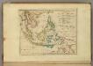
Islands of the East Indies.
1 : 23000000 Carey, Mathew
Atlas für Handel und Industrie: Für Kaufleute, Fabrikante u. Gewerbetreibende, Handlungs- u. Gewerbe-Schulen
Malay Archipelago.
1 : 10000000 John Bartholomew and Son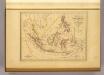
Malaisie.
1 : 18500000 Malte-Brun, Conrad, 1775-1826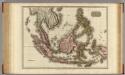
East India Isles.
1 : 7200000 Pinkerton, John, 1758-1826
Islands: China-New Holland.
1 : 23000000 Bowen, Frances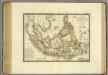
Grand Archipel d'Asie.
1 : 10200000 Brue, Adrien Hubert, 1786-1832
The archipelago of the East, being the Sunda, the Molucca, and Phillipps. Islands, he chief settlements of the Dutch in India are in the Sunda and Molucca Islands
1 : 15500000
Iles de la Sonde, Philippines.
1 : 11700000 Garnier, F. A., 1803-1863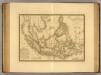
Grand Archipel d'Asie.
1 : 10200000 Picquet, C.


