Maps of Colón Province
De kusten van Porto Bello van Nombre de Dios tot Chagre int groot geleegen in de Westindies
Panama Gerard van Keulen
Bay et Chateau de Porto Bello [Karte], in: Atlas nouveau, contenant toutes les parties du monde [...], Bd. 2, S. 240.
1 Karte aus Atlas Sanson, Nicolas Jaillot, Alexis Hubert und Mortier, Pieter
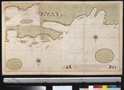
This plan of the harbour, town and forts of Porto Bello (taken by Edward Vernon Esq.r, Vice Admiral of the Blue on the 22nd of November 1739, with six men of war only)
1 : 11350 drawn by Lieuten.t Philip Durell is ... inscribed to the Rt. Hon.ble Sir Charles Wager, First Lord Commissioner of the Admiralty copied from the original ... by Ja. Rentone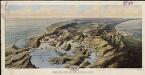
Bird's-eye view of the Panama Canal
1 : 1
Panama Canal Zone. Virgin Islands.
1 : 430000 Hammond, C.S.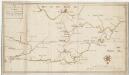
A map of part of the Isthmus of Darien, shewing the communication with Panama, from Portobello & Chagre both by land, and by water
1 : 190080
Panama.
1 : 1045000 Rand McNally and Company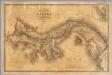
Carta corografica del Estado de Panama
1 : 810000 Ponce de Leon, Manuel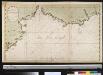
De kust van Cartagena en Darien begint van Cap Agua tot Schude de Verago met alle desselfs havens, bayen, rivieren, eylanden, droogtens etc. alles na de nieuwste observatie opgestelt
Colombia Johannes van Keulen
Dept. del Ismo.
1 : 2750000 Restrepo, Jose Manuel, 1781-1863
A draft of the Golden & adjacent Islands, with part of ye Isthmus of Darien as it was taken by Capt. Ienefer where ye Scots West-India Company were settled ; A New map of ye Isthmus of Darien in America, the Bay of Panama, the Gulph of Vallona...
1 : 1
Partie, Colombie. Amer. Merid. 1.
1 : 1641836 Vandermaelen, Philippe, 1795-1869
Karte des Isthmus von Nicaragua und Panamá in Mittel-America mit den verschiedenen Canal-Projecten zur Verbindung des Atlantischen u. Stillen Oceans nach J. Baily und den besten Quellen
zgst. von A. v. Bülow gest. in d. Lith. Anstalt v. H. Delius Berlin : Duncker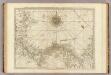
The Isthmus of Panama with the coast from Great River on the Moskito Shore to Cartagena.
1 : 1560000 Jefferys, Thomas
Map Of The Oil District Of Pennsylvania.
1 : 47520 Plumb, H.S.
Map Of The Oil District Of Pennsylvania.
1 : 47520 Plumb, H.S.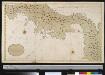
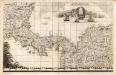
Een gedeelte van Nova Hispania vertoonende de Golf van Panama en t Land daer bewesten
Panama A. Boot, Gomez de Trasmonte & Joan Vingboons Gerard van Keulen
Isthmus of Panama.
1 : 3700000 Tallis, J. & F.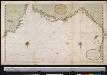
De custen van St. Marth Cartagena Darien, Tierra Firma en Costa Rica : van Caap Auga tot t Lac Nicaragua
Panama Gerard van Keulen
Carta dei Paesi sopra il Mare Meridionale de Panama a Guayaquil
La Historia de América del reverendo William Robertson (1721-1793), originalmente publicada en Londres en 1777, fue todo un éxito editorial en Europa. La obra, dividida en diez libros, aborda diferentes aspectos y episodios del descubrimiento y conquista del continente, particularmente la conquista de México y del Perú, siendo el istmo de Panamá y la región de Darién un paso estratégico en la historia colonial del Perú. En Italia hubo múltiples ediciones de la traducción de Antonio Pillori, la mayoría de las cuales incluyeron mapas. Esta versión se caracteriza por la inscripción “Aloja Inc”, en la parte inferior derecha del mapa Kitchin, Thomas (1719–1784). Aloja
The Isthmus of Panama with the coast from Great River on the Moskito shore to Cartagena
1 : 1500000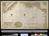
De kust van Carthagena, Tierra Firma, Costa Rica en de Honduras van Rio Grande de St. Martha tot Baija Honda int groot
Panama Gerard van Keulen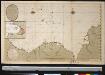
Nieuwen afteekening van de kust van Cartagena en Portobello beginnende van Santo Martha tot Rio Carabaca met allen desselfs havens baijen revieren eijlanden droogtens en dieptens Ao 1729
Panama Davelaar Johannes van Keulen
Carte Particuliere De Isthmus, Ou Darien, Qui comprend le Golfe De Panama &c. Cartagene, et les Isles Aux Environs. [Karte], in: Atlas nouveau, contenant toutes les parties du monde [...], Bd. 2, S. 243.
1 Karte aus Atlas Sanson, Nicolas Jaillot, Alexis Hubert und Mortier, Pieter
Ensayo de una carta fiscal de los Estados Unidos de Colombia
Mapa fiscal (borrador) en el que se señalan ferrocarriles y telégrafos (tanto en servicio como en proyecto), aduanas, minas, carreteras, etc., de algunas regiones del país. El mapa probablemente hizo parte de un proyecto fiscal y como tal resulta muy útil para el estudio de la geografía económica del país en la segunda mitad del siglo XIX Ayala, Daniel
Central America.
1 : 5068800 Colton, G.W.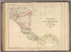
Central America.
1 : 3453120 Rogers, Henry Darwin
Terra firma et novum regnum Granatense et Popayan
1 : 4200000 Blaeu, Willem Janszoon, 1571-1638 Guiljelmus Blaeuw excuditi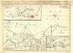
Carte particuliere de Isthmus, ou Darien, qui comprend le Golfe de Panama &c., Cartagene et les isles aux environs
1 : 1850000 Chez J. Cóvens et C. Mortier