Maps of Bingerville

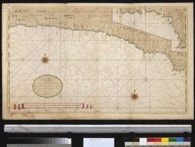
Een gedeelte van de kust van Gunea van Costa La Hon tot Cabo Trespuntas : vertoonende de kust van Adaows, Costa de Bonnegens ende Quaas kust
Ghana Gerard van Keulen
Carte des colonies de l'A.O.F. Bingerville
1 : 500000 Afrique occidentale française. Service géographique Paris : Henry Barrère
Colonie de la Côte d'Ivoire. Grand Lahou. Lagune de Lahou et rivière Bandama
1 : 150000 Pobéguin, Henri 1856-1951 [Paris] :
Goald Coast Survey
Gold Coast Survey. Scale, 1 : 62,500. Accra : Gold Coast Survey Headquarters, etc.
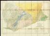
Côte d'Ivoire. Sassandra, Fresco
1 : 150000 Pobéguin, Henri 1856-1951 [Paris] : Ministère des Colonies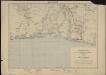
Carte de la Côte d'Ivoire dressée par A. Meunier. Bingerville
1 : 500000 A. Meunier Paris : Service Géographique des Colonies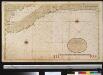
Een gedeelte van de kust van Gunea van C. das Palmas tot Costa La Hou vertoonende de kusten van Malegens en Grijn kust
Ivory Coast Gerard van Keulen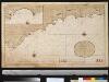
Een gedeelte van de kust van Gunea van C. Trespuntas tot C. Corso : vertoonende t Westelijkste van de Goutkust
Ghana Pieter Hinke Gerard van Keulen
Cote d'Or. Afrique 35.
1 : 1641836 Vandermaelen, Philippe, 1795-1869
Carte administrative de la Côte d'Ivoire. Répartition des cercles au 1er janvier 1909
1 : 2000000 Afrique occidentale française. Service géographique
The Gold Coast with Togoland under British Mandate
Huppenbauer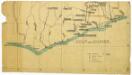
Untitled

Eastern District of the Gold Coast. The Head-Stations and the Out-Stations of the Basel Mission are underlined
Geological Map of the Gold Coast. Southern Sheet. Showing Positions of Gold Mines and Prospects
Special map of the inland countries on the Gold Coast up to Kumasi, an Anglo-African theater of war in 1874. By A. Petermann

Kaart van de Goud-Kust of Kust van Guinea / door Js. van den Bosch ; gegraveerd door C. van Baarsel en Zoon
C. van Baarsel en Zoon s-Gravenhage ; Amsterdam : Gebroeders van Cleef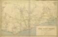
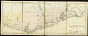
Map of the Gold Coast Colony and neighbouring territories
Map of the Gold Coast Colony and neighbouring territories, IDWO 1097. Great Britain. War Office. Intelligence Division. [London] : [War Office, Intelligence Division].
Ghana Road Map (South) 1957
Road map of Ghana, GSGS 4903. Later redesignated as Series G451. Great Britain. War Office. [London] : D. Survey, War Office & Air Ministry.
Côte d'Ivoire [Tableau d'assemblage]
1 : 150000 Pobéguin, Henri 1856-1951 [Paris] : Ministère des Colonies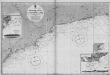
Gold Coast (1911)
[Africa. West Coast. Gold Coast. Achowa Point to Cape Coast Castle. Surveyed ... 1837]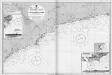
Gold Coast (1920)
[Africa. West Coast. Gold Coast. Achowa Point to Cape Coast Castle. Surveyed ... 1837]
Côte d'Ivoire. Haut-Sassandra, Daguire
1 : 150000 Pobéguin, Henri 1856-1951 [Paris] : Ministère des Colonies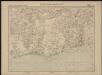
Carte de l'Afrique occidentale française. Bingerville, Porto-Novo
1 : 2000000 France. Service géographique des colonies [Paris] : Service géographique des colonies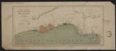
Carte des possessions anglaises et françaises sur le Golfe de Guinée
1 : 4600000 Paris : impr. de F. Menetrier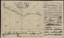
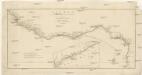
Pas caarte vande Gryen-Cust en Adaows Qua Quaas tuhessen de Serraliones en C. de Tres Puntas
1 : 2500000 t'Amsterdam : bij Joannes van Keulen Boeck-ver cooper en graad boog maecker by de Nieuwe-brug inde gekroonde Lootsman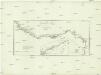
Guinea zwischen Sierra-Leone und dem Aequator
1 : 4120000 Guinea Anville, Jean-Baptiste Bourguinon d' Schraembl, Franz Anton F.A. Schraembl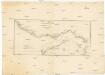
Guinea zwischen Sierra-Leone und dem Aequator
1 : 4120000 Guinea Anville, Jean-Baptiste Bourguinon d' F. A. Schraembl
Carte de la boucle du Niger / dressée par Spicq ; Service Géographique des Colonies
1 : 1500000 Annotatie: Met Index alfabetique (76 p.) Henri Eugène Spicq; Service Géographique des Colonies Paris : Maison Andriveau-Goujon, Henri Barrère
Guinee, entre Serre-Lione et le passage de La Ligne.
1 : 4150000 Anville, Jean Baptiste Bourguignon d, 1697-1782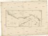
Guinea zwischen Sierra-Leona und dem Aequator
1 : 4110000 Guinejský záliv Anville, Jean-Baptiste Bourguinon d' Schraembl, Franz Anton F.A. Schraembl