Maps of Northeast Region
De zeekusten van Gunea van C. Verde tot Cabo de Bona Esperanco als mede de kusten van Brasil op wassende grade
Atlantic Ocean Gerard van Keulen
L'Ocean, Fernand de Noronha.
1 : 14800000 Compagnie des Indes
Carte de la partie de l'ocean vers l'equateur entre les cotes d'Afrique et d'Amerique où la situation des isles, bancs, et vigies
2 Karten auf einem Blatt : Kupferdruck ; Bildgrösse 48 x 64 cm Buache Philippe Buache
Particular draughts of some of the chief African Islands in the Mediterranean, as also in the Atlantic and Ethiopic Oceans
1 : 1
Composite: La Guinee.
1 : 9000000 Bonne, Rigobert, 1727-1794
Senegambien, Sudan, Guinea.
1 : 14700000 Berghaus, Heinrich; Flemming, Carl; Sohr, Karl
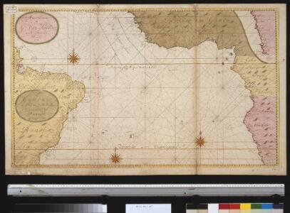
Paskaart van Gvinea van C. Verde tot R. de Galion
1 Karte : Kupferdruck ; 43 x 53 cm Doncker bÿ Hendrick Doncker in de Nieuwebrugsteeg
Guinee, Congo.
1 : 15000000 Clouet, J. B. L. (Jean-Baptiste Louis), b. 1730
Tractus littorales Guineæ a Promontorio Verde usque ad sinum Catenbelæ
1 Karte : Kupferdruck ; 49 x 55 cm Renard apud L. Renard
Nigritarum Regnum. [Karte], in: Novus atlas absolutissimus, Bd. 6, S. 171.
1 Karte aus Atlas Janssonius Offizin
[136][139] Tractus Littorales Guineae ..., uit: Atlas sive Descriptio terrarum orbis
Annotatie: Gedigitaliseerde versie. Amsterdam. Heiloo : Picturae (vervaardiger), 2015. tiff-bestand. Gedigitaliseerd: 07-01-2015; Origineel: Universiteitsbibliotheek Vrije Universiteit (XL.05127.-) ; Netherlands; Titelpagina ontbreekt Wit, Frederik de Amsterdam : Frederick de Wit
Übersicht der neuern Erforschungen in Mittel-Africa
Hand-Atlas über alle Theile der Erde nach dem neuesten Zustande und über das Weltgebäude Stieler, Adolf bei Justus Perthes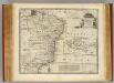
Brasil.
1 : 9000000 Bowen, Emanuel
[Afrika, Blatt 3]
Adolf Stieler's Handatlas über alle Theile der Erde und über das Weltgebäude Stieler, Adolf Justus Perthes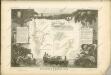
Amerique Meridionale 2.
1 : 6400000 Brue, Adrien Hubert, 1786-1832
Accuratissima Brasiliae Tabula. [Karte] Baya de todos os Sanctos [Nebenkarte] Villa d'Olinda de Pernambuco [Nebenkarte], in: Novus atlas absolutissimus, Bd. 6, S. 243.
1 Karte aus Atlas Janssonius Offizin
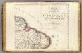
Nigritarum regio
1 : 20000000 [S.l. : s.n.]
Pascaart van de zee-custen van Angola, en Cimbebas van Rivier de Galion tot C. de Bona Esperanca
1 Karte : Kupferdruck ; 42 x 54 cm Doncker by Hendrick Doncker boeckverkoper inde Nieuwebrug-steeg in 't Stuiermans gereetschap
NIGRITARVM | REGIO.
Amstelædami Ioannes Blaeu Excud.
Brasilia [Karte], in: Theatrum orbis terrarum, sive, Atlas novus, Bd. 2, S. 351.
1 Karte aus Atlas Blaeu, Joan Blaeu, Willem Janszoon
Brasilia [Karte], in: Le théâtre du monde, ou, Nouvel atlas contenant les chartes et descriptions de tous les païs de la terre, Bd. 2, S. 338.
1 Karte aus Atlas Blaeu, Willem Janszoon und Blaeu, Joan Blaeu, Willem Janszoon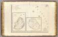
L'Afrique 3.
1 : 10000000 Brue, Adrien Hubert, 1786-1832
Untitled

Sud-America II.
1 : 13000000 Sohr, Karl
Littora Brasiliæ
1 Karte : Kupferdruck ; 47 x 56 cm Renard apud L. Renard
[146][149] Littora Brasiliae ... Pascaert van Brasil, uit: Atlas sive Descriptio terrarum orbis
Annotatie: Gedigitaliseerde versie. Amsterdam. Heiloo : Picturae (vervaardiger), 2015. tiff-bestand. Gedigitaliseerd: 07-01-2015; Origineel: Universiteitsbibliotheek Vrije Universiteit (XL.05127.-) ; Netherlands; Titelpagina ontbreekt Wit, Frederik de Amsterdam : Frederick de Wit
BRASILIA
Excudebat Johannes Blaeu
Africa Southern.
1 : 8000000 Hall, S. (Sidney)