Maps of Lolland Municipality
Een gedeelte van de Beldt Zee vertoonende desselfs Westelijkste zeekusten int grood bestek
Denmark Gerard van Keulen
Nova et Accurata descriptio totius Fioniae vulgo Funen. [Karte], in: Novus atlas absolutissimus, Bd. 1, S. 131.
1 Karte aus Atlas Janssonius Offizin
Fionia [Karte], in: Atlas, sive, Cosmographicae meditationes de fabrica mundi et fabricati figura, S. 144.
1 Karte aus Atlas Mercator, Gerhard

Fionia [Karte], in: Gerardi Mercatoris Atlas, sive, Cosmographicae meditationes de fabrica mundi et fabricati figura, S. 149.
1 Karte aus Atlas Mercator, Gerhard Montanus, Petrus
Fionia vulgo Funen [Karte], in: Le théâtre du monde, ou, Nouvel atlas contenant les chartes et descriptions de tous les païs de la terre, Bd. 1, S. 52.
1 Karte aus Atlas Blaeu, Willem Janszoon und Blaeu, Joan Blaeu, Willem Janszoon
Fiona vulgo Funen [Karte], in: Theatrum orbis terrarum, sive, Atlas novus, Bd. 1, S. 50.
1 Karte aus Atlas Blaeu, Joan Blaeu, Willem Janszoon
Fionia [Karte], in: Gerardi Mercatoris et I. Hondii Newer Atlas, oder, Grosses Weltbuch, Bd. 1, S. 112.
1 Karte aus Atlas Mercator, Gerhard und Hondius, Jodocus Jansson, Jan
Fionia vulgo Funen [Karte], in: Novus Atlas, das ist, Weltbeschreibung, Bd. 1, S. 36.
1 Karte aus Atlas Blaeu, Joan Blaeu, Willem Janszoon

FIONIA | vulgo | FVNEN.
[Amsterdam : Joan Blaeu]
Sonderburg 11, uit: Special-Karte von Mittel-Europa / nach amtlichen Quellen bearbeitet von W. Liebenow
1 : 300000 titelvariant: W. Liebenow's Mittel-Europa; Annotatie: Titel boven de bladen: W. Liebenow's Mittel-Europa Johannes Wilhelm Liebenow 1822-1897 Frankfurt a. M. : Ludwig Ravenstein
Fionia
1 Karte : Kupferdruck ; 34 x 38 cm Mercator; Hondius Henricus Hondius
Special-Karte von Nord-Schleswig im Maassstabe 1:150.000
1 : 150000 Fredericia (Dánsko) Petermann, August Justus Perthes
Special-Karte von Nord-Schleswig im Maassstabe 1:150.000
1 : 150000 Fredericia (Dánsko) Petermann, August Friedrich Ehrlich
4. Hadersleben (papieren versie, niet op linnen), uit: Topographische Uebersichtskarte des Deutschen Reiches / herausgegeben v. d. Kartogr. Abt. d. Königl. Preuß. Landesaufnahme
1 : 200000 titelvariant: Topogr. Übersichtskarte des Deutschen Reiches; Annotatie: Titel boven bladen ook: Topogr. Übersichtskarte des Deutschen Reiches; Annotatie geografische gegevens: Op elk blad twee maatstokken: 10 Kilometer = 5,5 cm; 1 geogr. Meile = 3,6 cm; Legenda onder op elk blad Königlich Preußische Landesaufnahme. Kartographische Abtheilung [S.l : Königlich Preußische Landesaufnahme, Kartographische Abtheilung]
4. hadersleben, uit: Topographische Uebersichtskarte des Deutschen Reiches / herausgegeben v. d. Kartogr. Abt. d. Königl. Preuß. Landesaufnahme
1 : 200000 titelvariant: Topogr. Übersichtskarte des Deutschen Reiches; Annotatie: Titel boven bladen ook: Topogr. Übersichtskarte des Deutschen Reiches; Annotatie geografische gegevens: Op elk blad twee maatstokken: 10 Kilometer = 5,5 cm; 1 geogr. Meile = 3,6 cm; Legenda onder op elk blad Königlich Preußische Landesaufnahme. Kartographische Abtheilung [S.l : Königlich Preußische Landesaufnahme, Kartographische Abtheilung]
10. Schleswig, uit: Topographische Uebersichtskarte des Deutschen Reiches / herausgegeben v. d. Kartogr. Abt. d. Königl. Preuß. Landesaufnahme
1 : 200000 titelvariant: Topogr. Übersichtskarte des Deutschen Reiches; Annotatie: Titel boven bladen ook: Topogr. Übersichtskarte des Deutschen Reiches; Annotatie geografische gegevens: Op elk blad twee maatstokken: 10 Kilometer = 5,5 cm; 1 geogr. Meile = 3,6 cm; Legenda onder op elk blad Königlich Preußische Landesaufnahme. Kartographische Abtheilung [S.l : Königlich Preußische Landesaufnahme, Kartographische Abtheilung]
11. Wester-Markelsdorf, uit: Topographische Uebersichtskarte des Deutschen Reiches / herausgegeben v. d. Kartogr. Abt. d. Königl. Preuß. Landesaufnahme
1 : 200000 titelvariant: Topogr. Übersichtskarte des Deutschen Reiches; Annotatie: Titel boven bladen ook: Topogr. Übersichtskarte des Deutschen Reiches; Annotatie geografische gegevens: Op elk blad twee maatstokken: 10 Kilometer = 5,5 cm; 1 geogr. Meile = 3,6 cm; Legenda onder op elk blad Königlich Preußische Landesaufnahme. Kartographische Abtheilung [S.l : Königlich Preußische Landesaufnahme, Kartographische Abtheilung]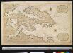
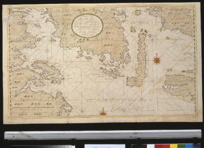
Nieuwe afteekening van het eijlandt Alsen en de vaste kust daar agter geleegen : vertoonende de rivieren van Apenrader en Flensborgh, is geleegen aen de west kust in de Belt Zee
Denmark Gerard van Keulen
DVCATVS | SONDERBORG | cum adjacentibus Territoriis | ALSSEN, SVNDEWITT, | et Luxburgh.
Matthis Peterss G.s. v. | Claus P. Goldtschmide unt gbr. | Huss. Cimbr. sculp. [Amsterdam : Joan Blaeu]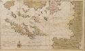
Dese eijlanden leggen aen de zuijtkand vant eijland Fuijnen in de Belt of Oostzee
Denmark Gerard van Keulen
23. Flensburg. (Germany)
1 : 100000 Reichsamt fur Landesaufnahme
Praefectvra Flensbvrgensis absque Nordgoeßherde
1 : 110000 Mollova mapová sbírka Mejer, Johannes Peters, Matthias Blaeu, Joan I.
TERRITORIA | ANGLEN | ET | SCHWANSEN | Anno 1649
Matthias und Clauss Petersen Goldtschmide und gebr. | Hus. Cimb. sculps. [Amsterdam : Joan Blaeu]
PRÆFECTVRA | FLENSBVRGENSIS | absque Nordgoeßherde.
Matthias & Nicolas Peters Goldtschmide | gebr. Husum. sculps. [Amsterdam : Joan Blaeu]
PARS ORIENTALIS | PRÆFECTVRÆ | HADERSLEBEN | Vulgo dictæ Baringsijßel.
Matthias Vnd Clauss Petersen | G.S. gebr. | Husumenss. sculps. [Amsterdam : Joan Blaeu]
PRÆFECTVRA | APENRADE | et Luntoft herde.
Christian Rothgiesser | Husum. sculpsit. [Amsterdam : Joan Blaeu]
PRÆFECTVRÆ | GOTTORPIENSIS | pars Borealis.
Matthias und Clauss Petersen | Goldtschmide gebr. Hus. sculps. [Amsterdam : Joan Blaeu]