Maps of Alacant / Alicante

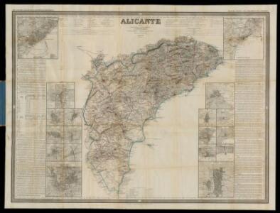
Alicante
1 : 200000 1 Mapa, b/n. Dins: Atlas de España y sus posesiones de ultramar. Es consulta un facsímil publicat per l'editorial Marqués de Encomienda el 1991 Coello, Francisco ; Madoz, Pascual [Imprenta del Atlas de España]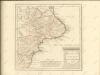

Mittelmeer
1 : 250000 Alicante (Španělsko) Reichs-Marine-Amt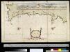
Een gedeelte van de kust van Murcia en Valentia van C. Palos tot Alicante in de Middellandse Zee
Spain Gerard van Keulen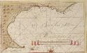
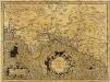
De reede van Alikante
Spain Gerard van Keulen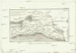
Mapa de la huerta de Orihuela
1 : 400000 Cavanilles, A. J. Enguidanos, T. L.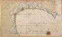
De baij van Altea een wijnig beoosten Alikante
Spain Gerard van Keulen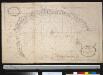
Afteekening van de baeij van Altea geleegen in de Middellandsche Zee aen de cust van Murcia beooste(n) Alicante
Spain Gerard van Keulen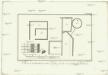
Plano de lo descubierto entre Hifac y Calp, en el reyno de Valencia
1 : 80 Valencie-oblast (Španělsko) Cavanilles, A. J. Enguidanos, T. L.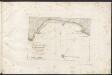
Pianta della Rada di Benidorme
Ia Distribuzione del portolano delle coste della penisola di Spagna e parte della costa di Africa Reale Litografia Militare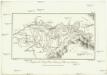
Azequia del rey, rio Xucar, y valle de Carcer
1 : 250000 Cavanilles, A. J. Enguidanos, T. L.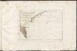
Pianta della parte Orientale del Ancoraggio di Calpe chiamato la Fosa
Ia Distribuzione del portolano delle coste della penisola di Spagna e parte della costa di Africa Reale Litografia Militare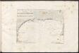
Pianta della Rada e Ancoraggio di Xavia
Ia Distribuzione del portolano delle coste della penisola di Spagna e parte della costa di Africa Reale Litografia Militare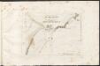
Pianta della Cala di Torre Vecchia
Ia Distribuzione del portolano delle coste della penisola di Spagna e parte della costa di Africa Reale Litografia Militare
Plan of the City and Catle of Alicant, besieged by the Chevalier d'Asfeldt Nov. 30th 1708. And surrendered by capitulation Apr. 19th 1709.
Tindal; Rapin
Excavaciones de Calp
1 : 65 Cavanilles, A. J. Enguidanos, T. L.
Excavaciones de Calp
1 : 60 Cavanilles, A. J. Enguidanos, T. L.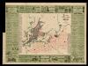
Plano industrial y comercial de Alcoy / es propiedad de J. Calvet
1 : 2500 1 Mapa. De la Guía geográfica, yndustrial y comercial de la empresa Calvet y Boix Calvet y Boix, Juan 0
Plan of the city and castle of Alicante
Tindal; Rapin
Plano industrial y comercial de Murcia / és propiedad de J. Calvet
1 : 2500 1 Mapa. De la Guía geográfica, yndustrial y comercial de la empresa Calvet y Boix Calvet y Boix, Juan 0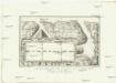
Banos de la reyna.
Calp (Španělsko) Cavanilles, A. J. Enguidanos, T. L.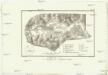
Mapa de Aigues-vives.
Aigües (Španělsko) Cavanilles, A. J. Enguidanos, T. L.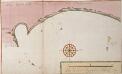
Dese reede lijt beoosten de haven van Cartagena
Spain Gerard van Keulen
Regni Valenciae tabula
1 Karte : Kupferdruck ; 53 x 44 cm López Homann. Hered. excud
Les royaumes de Valence et Murcie
1 Karte : Kupferdruck ; 54 x 42 cm Nolin; Silva; Cantelli da Vignola; Julien; López chez le Sr. Julien a l'hotel de Soubise, en casa de Thomas Lopez pensionista de S. M. c.a
Les royaumes de Valence et de Murcie
1 Karte : Kupferdruck ; 54 x 39 cm Fer; Danet chez G. Danet gendre de l'auteur sur le pont nôtre Dame a la sphere royale
Li regni di Valenza, e di Mvrcia
1 Karte : Kupferdruck ; 54 x 41 cm Cantelli da Vignola; Rossi; Barbey dati in luce da Domenico de Rossi erede di Gio. Giac.o de Rossi dalle sue stampe
Valentia regnvm. Co[n]testani. Ptol. Edentani Plin
1 Karte : Kupferdruck ; 33 x 45 cm Janssonius Joannes Janssonius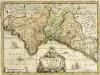
Valentia regnvm. Co[n]testani. Ptol. Edentani Plin
1 Karte : Kupferdruck ; 33 x 45 cm Valck; Schenk apud Gerardum Valk et Petrum Schenk
Valentia regnvm; Contestani, Ptol. Edentani, Plin
1 Karte : Kupferdruck ; 36 x 48 cm Blaeu apud Guiljelmum Blaeuw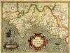
Regni Valentiæ typus
1 Karte : Kupferdruck ; 34 x 46 cm Mercator; Hondius Henricus Hondius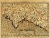
Regni Valentiæ typus
1 Karte : Kupferdruck ; 17 x 24 cm Mercator; Keere Cloppenburgh