Maps of Segovia
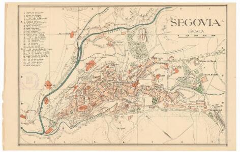
Segovia
1 mapa. Datat entre 1950 i 1959 aproximadament. 0 0
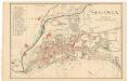
Segovia
1 : 200000 Coello, Francisco [Verlag nicht ermittelbar]
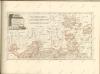
Mapa de las cercanias de Madrid
1 Karte : Kupferdruck ; 36 x 37 cm López s.n.
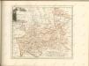
Mapa de la provincia de Guadalaxara
1 Karte : Kupferstich ; 37 x 38 cm López s.n.
Madrid
1 : 200000 1 Mapa imprès. Carpeta: Guerra Civil. Datació aproximada. C.T.V. Corpo Truppe Volontarie. Sezione Topocartografica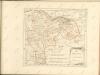

Madrid
1 : 200000 Coello, Francisco [Verlag nicht ermittelbar]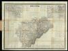
Segovia
1 : 200000 Coello, Francisco ; Madoz, Pascual [Imprenta del Atlas de España]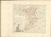

Mapa de la provincia de Segovia
1 Karte auf 4 Blatt : Kupferdruck ; 71 x 78 cm López s.n.
Segoviæ et Avilæ provinciarum charta geographica
1 Karte : Kupferdruck ; 43 x 55 cm López; Güssefeld; Vogel in lucem edita per Hom. Hered
Mapa de la provincia de Toledo
1 Karte : Kupferdruck ; 37 x 40 cm López s.n.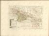

Castiliae novae pars orientalis
1 : 540000 Kastilie (Španělsko) Güssefeld, Franz L. López, Tomás apud Hommanianos Heredes
Invictissimo principi Phillipo V. Hispaniarum regi la Castille vieille et nouvelle avec l'Estremadure divisé en Estremadure de Castille et de Leon
1 : 1090000 Extremadura (Španělsko) Nolin, Jean-Baptiste Mendes Silva, Rodrigo I.B. Nolin
Il regno di Leone
1 Karte : Kupferdruck ; 55 x 41 cm Cantelli da Vignola; Rossi; Barbey dato in luce da Dom.co de Rossi erede di Gio. Giac.o de Rossi dalle sue stampe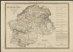
Cataluña con las nuevas divisiones
1 : 600000 formada por A. H. Dufour Paris : Bulla
Castilla La Vieja con las nuevas divisiones
1 : 600000 formada por A. H. Dufour Paris : Bulla
Il regno di Castiglia vecchia
1 Karte : Kupferdruck ; 42 x 54 cm Cantelli da Vignola; Rossi; Barbey Domenico de Rossi
[Carte d'Espagne et de Portugal en neuf feuilles, 5]
1 Blatt : 31 x 41 cm P.G. Chanlaire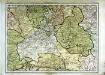
Espagne et Portugal, 5
1 Blatt : 31 x 42 cm Mentelle
[Carte d'Espagne et de Portugal en neuf feuilles, 2]
1 Blatt : 31 x 41 cm P.G. Chanlaire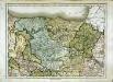
Espagne et Portugal, 2
1 Blatt : 31 x 42 cm Mentelle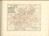

Castiliæ novæ pars occidentalis provincias Madrit, Toledo et Mancha comprehendens
1 Karte : Kupferdruck ; 48 x 46 cm Güssefeld; López apud Homannianos Heredes
Castiliæ novæ pars orientalis provincias Cuenca et Guadalaxara comprehendens
1 Karte : Kupferdruck ; 51 x 43 cm Güssefeld; López apud Homannianos Heredes