Maps of Tarragonès
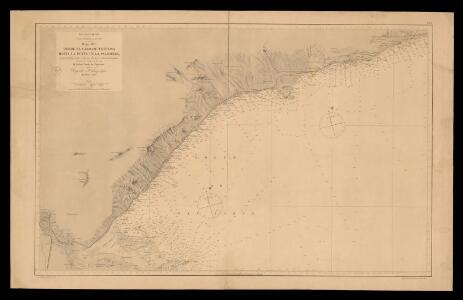
Desde el cabo de Tortosa hasta la punta de la Palomera / según los trabajos hechos en 1886 y en 1887 por la comisión Hidrográfica al mando del capitan de la fragata D. Rafael Pardo de Figueroa
1 Carta nàutica. Mar Mediterráneo. Costa oriental de España: Hoja XIII. . Datat entre 1886 i 1887. Riuidavets, J. ; Galvan, F. ; Serra ; Depósito Hidrográfico (Espanya)
Plan of the camp of Tarragona
1 mapa. Datat entre 1740 i 1749. Tindal; Rapin
Mapa geogràfic de Catalunya 1:100 000
1 : 100000 Mancomunitat de Catalunya. Servei Geogràfic
Mapa geològic de Catalunya 1:100.000
1 : 100000 Mancomunitat de Catalunya. Servei Geogràfic
Carte du gouuernement de Tortose
1 Karte : Kupferdruck ; 11 x 15 cm s.n.
De reede van de alfacques en R. Tortoza als ook de Golf van St. George int groodt
Spain Gerard van Keulen
Plan de la ville et molle de Taragone en Catalogne
1 Plan : Kupferdruck ; 41 x 51 cm Beaulieu s.n.
Carte du gouuernement de Taragonne
1 Karte : Kupferdruck ; 11 x 16 cm s.n.
Mapa planimètric de la Fatarella
1 : 25000 Instituto Geográfico y Estadístico (Espanya). Còpia feta pel Servei Geogràfic de la Mancomunitat de Catalunya.
Mapa planimètric de Vila-seca i Salou
1 : 25000 Instituto Geográfico y Estadístico (Espanya). Còpia feta pel Servei Geogràfic de la Mancomunitat de Catalunya.
Plano del Puerto del Fangar y Golfo de la Ampolla : levantado en 1880 por la Comisión Hidrográfica ...
1 : 22000 1 Mapa. - Full 297 A Galvan, C.; Bregante, S.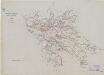
Mapa planimètric de Reus
1 : 25000 Instituto Geográfico y Estadístico (Espanya). Còpia feta pel Servei Geogràfic de la Mancomunitat de Catalunya.
Mapa planimètric de Mont-roig
1 : 25000 Instituto Geográfico y Estadístico (Espanya). Còpia feta pel Servei Geogràfic de la Mancomunitat de Catalunya.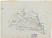
Mapa planimètric de Móra d'Ebre
1 : 25000 Instituto Geográfico y Estadístico (Espanya). Còpia feta pel Servei Geogràfic de la Mancomunitat de Catalunya.
Mapa planimètric del terme municipal d'Ascó
1 : 25000 Instituto Geográfico y Estadístico (Espanya). Còpia feta pel Servei Geogràfic de la Mancomunitat de Catalunya.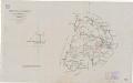
Mapa planimètric del Catllar
1 : 25000 Instituto Geográfico y Estadístico (Espanya). Còpia feta pel Servei Geogràfic de la Mancomunitat de Catalunya.
Mapa planimètric de Vandellòs
1 : 25000 Instituto Geográfico y Estadístico (Espanya). Còpia feta pel Servei Geogràfic de la Mancomunitat de Catalunya.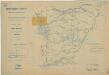
Mapa planimètric de Tortosa
1 : 25000 Instituto Geográfico y Estadístico (Espanya). Còpia feta pel Servei Geogràfic de la Mancomunitat de Catalunya.
Mapa planimètric de l'Ametlla de Mar
1 : 25000 Instituto Geográfico y Estadístico (Espanya). Còpia feta pel Servei Geogràfic de la Mancomunitat de Catalunya.
Mapa planimètric de Corbera
1 : 25000 Instituto Geográfico y Estadístico (Espanya). Còpia feta pel Servei Geogràfic de la Mancomunitat de Catalunya.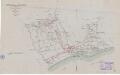
Mapa planimètric de Cambrils
1 : 25000 Instituto Geográfico y Estadístico (Espanya). Còpia feta pel Servei Geogràfic de la Mancomunitat de Catalunya.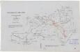
Mapa planimètric d'Alforja
1 : 25000 Instituto Geográfico y Estadístico (Espanya). Còpia feta pel Servei Geogràfic de la Mancomunitat de Catalunya.
Mapa planimètric de Tarragona
1 : 25000 Instituto Geográfico y Estadístico (Espanya). Còpia feta pel Servei Geogràfic de la Mancomunitat de Catalunya.
Mapa planimètric de Constantí
1 : 25000 Instituto Geográfico y Estadístico (Espanya). Còpia feta pel Servei Geogràfic de la Mancomunitat de Catalunya.
Mapa planimètric de Pratdip
1 : 25000 Instituto Geográfico y Estadístico (Espanya). Còpia feta pel Servei Geogràfic de la Mancomunitat de Catalunya.
Mapa planimètric del Vendrell
1 : 25000 Instituto Geográfico y Estadístico (Espanya). Còpia feta pel Servei Geogràfic de la Mancomunitat de Catalunya.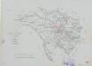
Mapa planimètric de la Selva del Camp
1 : 25000 Instituto Geográfico y Estadístico (Espanya). Còpia feta pel Servei Geogràfic de la Mancomunitat de Catalunya.
Mapa planimètric de les Borges del Camp
1 : 25000 Instituto Geográfico y Estadístico (Espanya). Còpia feta pel Servei Geogràfic de la Mancomunitat de Catalunya.
Mapa planimètric de la Pobla de Montornès
1 : 25000 Instituto Geográfico y Estadístico (Espanya). Còpia feta pel Servei Geogràfic de la Mancomunitat de Catalunya.