Maps of Tetouan Province
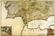
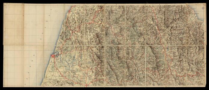
Mapa del norte de Marruecos
1 : 100000 1 full d'1 mapa en 12 fulls entelats de 2 en 2 fulls dins d'un estoig. Datat entre 1920 i 1930. [Cuerpo de Estado Mayor del Ejército?]
Tanger
1 : 250000 Larras, Nestor Prosper 18..-19..; France. Service géographique de l'armée Paris : H. Barrère
Carte générale du Maroc à l'échelle de 1 : 500 000 e. Tanger
1 : 500000 Maroc. Service géographique Rabat : Service géographique du Maroc
Maroc (500 000 e). Tanger
1 : 500000 France. Service géographique de l'armée Service géographique de l'Armée
Carte nouvelle De L'ISLE de CADIX & du Detroit de GIBRALTAR
1 : 500000 Cádiz (Španělsko) Petit, Jean de Schneider, Ruprecht A. Weidler
Carte nouvelle de l'Isle de Cadix & du Detroit de Gibraltar
1 : 390000 Cádiz (Španělsko) Petit, Jean de aux depens des Heritiers du feu m. le docteur Homann
Carte touristique du Maroc
1 : 500000 Fez (Maroko) Service géographique
Castellum Gibraltar in Andalusia situm cum celebri freto inter Europam et Africam, annexis circumjacentibus portubus et castellis
1 : 470000 accurate designatum cura et sumptibus Tobiae Conradi Lotter Aug. Vindel : [T. Lotter]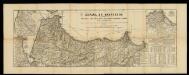
España en Marruecos: mapa de la zona, en el norte del Imperio, asignada a España según el Tratado de 1912 / formado por los señores Elola y Méndez, teniendo presentes los trabajos nacionales y extrageros, dignos de confianza, publicados hasta la fecha
1 : 450000 1 Mapa en fulls, b/n & 2 fulls. Franja de solapament descomptada a les mides. - Conté 4 finestres a escala 1:225 000: Larache y Alcazar; Terreno entre Ceuta y Tetuan; Chafarinas y Cabo de Agua; Cercanias de Melilla y posiciones avanzadas. Datació aproximada. Méndez, J. Lit. J. Mendez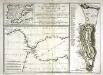
Plan géometral de la montagne et de la ville de Gibraltar
1 Plan : Kupferdruck ; 33 x 15 cm, Bildgrösse: 34 x 47 cm Bonne; Chalmandrier; Longchamps chez les Freres Barthelemy, chez le Sr. Longchamps
Nouvelle carte du détroit de Gibraltar et de l'isle de Cadix
1 Karte : Kupferdruck ; 54 x 46 cm Santini; Remondini chez M.r Remondini
Plan topo-hydrographique du détroit de Gibraltar
1 Karte : Kupferdruck ; 44 x 53 cm Vezou; Lattré; Lynslager chez Lattré graveur rue St. Jacques vis-a-vis celle de la parcheminerie à la ville de Bordeaux
Carte nouvelle de l'isle de Cadix [et] du detroit de Gibraltar
1 Karte : Kupferdruck ; 55 x 47 cm Weidler; Petit; Schneider Homännische Erben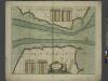
A chart of the STRAITS of GIBRALTER
from The sea-atlas : containing an hydrographical description of most of the sea-coasts of the known parts of the world.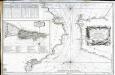
Carte du détroit de Gibraltar
1 Karte : Kupferdruck ; 56 x 87 cm Bellin s.n.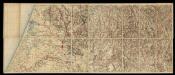
Mapa del norte de Marruecos
1 : 100000 1 full d'1 mapa en 12 fulls entelats de 2 en 2 fulls dins d'un estoig. Datat entre 1920 i 1930. [Cuerpo de Estado Mayor del Ejército?]
Mapa del norte de Marruecos
1 : 100000 1 full d'1 mapa en 12 fulls entelats de 2 en 2 fulls dins d'un estoig. Datat entre 1920 i 1930. [Cuerpo de Estado Mayor del Ejército?]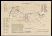
Mapa sociológico de la zona de inflencia española en el norte de Marruecos / por D. Antonio Martinez Pajares, Doctor en Derecho
1 : 500000 1 Mapa, col. Dedicatòria ms. de l'autor, datada el 1916. Datació aproximada. Martínez Pajares, Antonio Lit. J. Mendez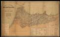
Mapa de la parte norte de Marruecos / por la Comisión de Cuerpo de E.M. del Ejercito ; Talleres del Depósito de la Guerra
1 Mapa. Datació aproximada. Estado Mayor del Ejército (Espanya)
Reiseweg im Marokkanischen Atlas-Vorland im Frühjahr 1899
1 : 2000000 Atlas (pohoří) Fischer, Theobald Gesellschaft für Erdkunde
43. Spagna, Portogallo sud.
1 : 1500000 Touring club italiano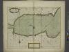
A chart of the sea coast of SPAIN from the Straits mouth to C de Gat and of the sea coast of BARBARY from the Straits mouth to C de Hone
from The sea-atlas : containing an hydrographical description of most of the sea-coasts of the known parts of the world.
Spain, South coast form Gibraltar to Alicante, and north coast of Barbary to cape Ferrat, from Spanish authorities, with corrections by Capt. W.H.Smyth. The north coast of Africa is from French surveys of 1833-55.
Walker, J. & C.
Espagne et Portugal. Flle. S.O.
1 : 1250000 Vivien St Martin, L.
Neueste Generalkarte von Portugal und Spanien, 4
1 Blatt : 69 x 50 cm Schrämbl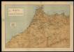
Mapa del imperio de Marruecos
1 Mapa. Datació aproximada. Lit. Mateu
[Spanien und Portugal in 4 Blättern]
Hand-Atlas über alle Theile der Erde nach dem neuesten Zustande und über das Weltgebäude Stieler, Adolf bei Justus Perthes
[Spanien und Portugal in 4 Blättern]
Hand-Atlas über alle Theile der Erde und über das Weltgebäude Stieler, Adolf Justus Perthes
Spain = España : III
1 mapa. J. & C. Walker sculp The Society for the Diffusion of Useful Knowledge; Baldwin & Gradock