Maps of Europe

Russia Europea: Carta politica-administrativa della Russia dei Sovieti nell 1923
1 : 5000000 Istituto Geografico de Agostini di C. Rossi e A.M. Boroli Visintin, L.
Russie d'Europe, Pologne.
1 : 8300000 Brue, Adrien Hubert, 1786-1832
Praktische Geschäfts und Reisekarte sämmtlicher Staaten von Europa enthaltend die vorzüglichsten Strassen-Verbindungen mit Angage der Distanzen und der bestehenden Eisenbahnen: Nebst einem Theile von Africa u. Asien, und zwar die Länder: Marocco, Algerien u. Tunis, ganz Kleinasien, und ein Theil von Persien
Schulz, R. A.
Soubor němých map pro gymnasia a odborné školy

Volkerkarte von Russland.
1 : 13300000 Andree, Richard
Ravensteinkarte Osteuropa
1 : 3333333 Evropa střední a východní Ravensteins Geographische-Verlagsanstalt und Druckerei
Mapa slovanského světa

Russian In Europe.
1 : 7603200 Fullarton, A. & Co.
Russie d'Europe, Pologne.
1 : 8000000 Levasseur, E.
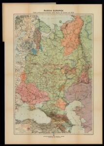
Russia Europea.
1 : 4300000 Marzolla, Benedetto
Novissima Russiae Tabula [Karte], in: Novus atlas absolutissimus, Bd. 1, S. 70.
1 Karte aus Atlas Janssonius Offizin
Europäisches Russland
1 : 13300000 Russland / Europäischer Teil
Mapa slovanského světa

Novissima Russiae Tabula [Karte], in: Gerardi Mercatoris et I. Hondii Newer Atlas, oder, Grosses Weltbuch, Bd. 1, S. 124.
1 Karte aus Atlas Mercator, Gerhard und Hondius, Jodocus Jansson, Jan
Kaiserthum Russland in Europa
Rusko západní
Composite: Russia, Finland.
1 : 6000000 John Bartholomew and Son
European Russia.
1 : 8900000 Rand McNally and Company
Kaiserthum Russland in Europa

Karte der Bevölkerung Russlands im 9. Jahrhundert
Russland Bevölkerungsdichte
Russia In Europe.
1 : 15206400 Tallis, J. & F.
Carta politica della Russia / Francesco Vallardi
1 : 3300000 Francesco Vallardi
TABVLA | RVSSIÆ | ex autographo, quod delineandum | curavit Foedor filius Tzaris Boris desum- | ta; et ad fluvios Dwinam, Zuchanam, aliaque | loca, quantum ex tabulis ex notitiis ad nos dela- | tis fieri potuit, amplificata...
Amstelodami, | Excusum Apud Guiljelmum Blaeu
Russia.
1 : 7760000 Johnson, A.J.
Russia.
1 : 7760000 Johnson, A.J.
Tabula Russiae [...] [Karte] Moscua ad Architypum Foedori Borißowitsi [Planvedute, Karte], in: Le théâtre du monde, ou, Nouvel atlas contenant les chartes et descriptions de tous les païs de la terre, Bd. 1, S. 67.
1 Karte aus Atlas Blaeu, Willem Janszoon und Blaeu, Joan Blaeu, Willem Janszoon
Europaeisches Russland
E. von Sydow's Schul-Atlas in sechs und dreissig Karten Sydow, Emil von bei Justus Perthes
Eur. Russland.
1 : 6588000 Weiland, C. F. (Carl Ferdinand), d. 1847
Russia in Europe
1 : 10000000 1 Karte : mehrfarbig ; 42 x 31 cm John Bartholomew
Karte der Bevölkerung Russlands im 19. Jahrhundert
Russland Bevölkerungsdichte