Maps of Rajec

III. vojenské mapování 4361/4
1 : 25000
[Gradkartenblatt]
1 : 25000 Slovensko Vojenský zeměpisný ústav
III. vojenské mapování 4361
1 : 75000
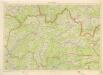
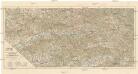
Žilina
1 : 75000 Slovensko Vojenský zeměpisný ústav
Žilina
1 : 75000 Slovensko Vojenský zeměpisný ústav
Sillein und Wagg-Bistritz.
from Spezialkarte der osterreichisch-ungarischen Monarchie.
Mappa comitatvs Thvrotziensis
1 : 165000 Turanská nížina Mikoviny, Sámuel Nicolai, Georg David Christoph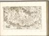

C. Thurotziensis
Slowakei Komitat Martin (Slowakei)
Žilina
1 : 75000 Bytča (Slovensko : oblast) Vojenský zeměpisný ústav
Žilina a Povážská Bystrica
1 : 75000 Považská Bystrica (Slovensko : oblast) Zeměpisný ústav Min. nár. obrany
Mappa Comitatvs Thvrotziensis.
1 : 160000 Mollova mapová sbírka Mikoviny, Sámuel
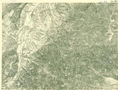
[Gradkartenblatt]
1 : 25000 Martin-oblast (Slovensko) Vojenský zeměpisný ústav
[Gradkartenblatt]
1 : 25000 Martin-oblast (Slovensko) Vojenský zeměpisný ústav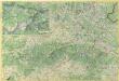
Malá Fatra


Trenčín
1 : 75000 Slovensko Vojenský zeměpisný ústav
Trentschin 120, uit: Special-Karte von Mittel-Europa / nach amtlichen Quellen bearbeitet von W. Liebenow
1 : 300000 titelvariant: W. Liebenow's Mittel-Europa; Annotatie: Titel boven de bladen: W. Liebenow's Mittel-Europa Johannes Wilhelm Liebenow 1822-1897 Frankfurt a. M. : Ludwig Ravenstein
Stolice Trenčín. Stolice Turec
Trenčín (Okres), Komitat Martin (Slowakei), ethnische Gruppe
C. Trencsin
Slowakei Komitat Trentschin
Markgrafschaft Mähren und Herzogthum Schlesien


Comitat Trencsin
1 : 288000 Trenčín-oblast (Slovensko)
Comitat Trencsin
1 : 280000 Trenčín-oblast (Slovensko)
Die Markgrafschaft Maehren mit dem Herzogthume Schlesien
Střední Pováží
1 : 200000 Pováží (Slovensko) odbor Klubu českoslov. turistů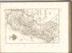
General-Karte des Königreiches Galizien und des Herzogthumes Bukovina

Trencsén vármegye térképe
1 : 355000 Trenčín (Slovensko : oblast) Kogutowicz, Manó Magyar Földrajzi Intézet