Maps of gmina Węgierska Górka

III. vojenské mapování 4162/4
1 : 25000
[Gradkartenblatt]
1 : 25000 Orava (Polsko a Slovensko) Vojenský zeměpisný ústav
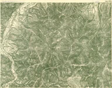
Saybusch
1 : 75000 Polsko Adler K. u. k. Militärgeographisches Institut
III. vojenské mapování 4162
1 : 75000
Saybusch
1 : 75000 Saybusch Schrift und Gerippe v. W. Ahl. Terrainschraffirung v. Oberlt. Hettwer
Hrčava
1 : 75000 Hrčava (Česko) Vojenský zeměpisný ústav
Żywiec
1 : 75000 Polsko Vojenský zeměpisný ústav
Żywiec
1 : 75000 Polsko Čs. voj. zeměpisný ústav
Żywiec
1 : 75000 Polsko Kartografické odd. při Min. nár. obrany
Saybusch.
from Spezialkarte der osterreichisch-ungarischen Monarchie.
157. Pless, uit: Topographische Uebersichtskarte des Deutschen Reiches / herausgegeben v. d. Kartogr. Abt. d. Königl. Preuß. Landesaufnahme
1 : 200000 titelvariant: Topogr. Übersichtskarte des Deutschen Reiches; Annotatie: Titel boven bladen ook: Topogr. Übersichtskarte des Deutschen Reiches; Annotatie geografische gegevens: Op elk blad twee maatstokken: 10 Kilometer = 5,5 cm; 1 geogr. Meile = 3,6 cm; Legenda onder op elk blad Königlich Preußische Landesaufnahme. Kartographische Abtheilung [S.l : Königlich Preußische Landesaufnahme, Kartographische Abtheilung]

Makow und Podvilk.
from Spezialkarte der osterreichisch-ungarischen Monarchie.
Podrobná mapa Markrabství moravského a Vévodství slezského
1 : 100000 Istebna (Polsko) Srp, Jan Jos. R. Vilímek
Maków und Podvilk
1 : 75000 Oravská Polhora-oblast (Slovensko) Adler K. u. k. Militärgeographisches Institut
III. vojenské mapování 4163/3
1 : 25000
[Gradkartenblatt]
1 : 25000 Orava (Polsko a Slovensko) Vojenský zeměpisný ústav
Auschwitz u. Sator
1 : 2000000 Herzogtum Auschwitz
Ducatus Oswieczensis, Et Zatoriensis, Descriptio. [Karte], in: Theatrum orbis terrarum, S. 375.
1 Karte aus Atlas Ortelius, Abraham Vrients, Jan Baptista
Ducatus Oswieczensis, Et Zatoriensis, Descriptio. [Karte], in: Theatrum orbis terrarum, S. 280.
1 Karte aus Atlas Ortelius, Abraham

Stolice Orava a Liptov
Komitat Arva, Komitat Liptau, ethnische Gruppe
Bielitz 106, uit: Special-Karte von Mittel-Europa / nach amtlichen Quellen bearbeitet von W. Liebenow
1 : 300000 titelvariant: W. Liebenow's Mittel-Europa; Annotatie: Titel boven de bladen: W. Liebenow's Mittel-Europa Johannes Wilhelm Liebenow 1822-1897 Frankfurt a. M. : Ludwig Ravenstein
Orawa i Spisz
Orava (Polsko a Slovensko)
General-Karte des Königreiches Galizien und des Herzogthumes Bukovina

[Rechterblad], uit: Podrobná mapa Vysokých Tater
1 : 25000 Annotatie: Opname 1896/97, gedeeltelijk herzien 1931; Annotatie geografische gegevens: Inzet: Pérehled oblasti Tater. - 1:200.000 [Praag : Vojenský Zeméepisný Ústav]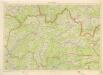
Kraj Žilinský

Silésie de Teschen
1 : 200000 Cieszyn-oblast (Polsko) Čs. voj. zeměpis. ústav
Silésie de Teschen
Cieszyn-oblast (Polsko) Čs. voj. zeměpis. ústav