Maps of Vichada

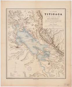
Lago Titicaca : plano formado sobre los trabajos de Pentland, Raimondi, Agassiz, etc. : para la conferencia que en la noche del 21 de Diciembre del ano de 1891, dio en el l'oeal de la Sociedad Geografica, el Dr. Dn. Ignacio La Puenta sobre el estudio monografico del Lago, bajo su aspecto fisico e historico
1 : 500000 Baluarte, Rafael E Sociedad Geografica de Lima
Departamento de Puno.
1 : 1090000 Paz Soldan, Mariano Felipe, 1821-1886
Curacao.
1 : 316800 Lucas, Fielding Jr.
Curaçao
1 : 120000
Nieuwe Afteekening van het Eyland Curacao vertoonende alle desselfs geleegentheeden mitsgaders de haven van St. Anna en't Fort Amsterdam
1 : 160000
Kaart van het eiland Curaçao / door Js. van den Bosch ; gegraveerd door C. van Baarsel en Zoon
C. van Baarsel en Zoon s-Gravenhage ; Amsterdam : Gebroeders van Cleef
Curacao.
1 : 150000 Keulen, Gerard van
Blad XV, uit: Topographische kaart van Curaçao
1 : 20000 Annotatie: Voor aanwezige bladen zie overzichtsblad [S.l. : s.n.] / (Den Haag : Smulders)
Blad XII, uit: Topographische kaart van Curaçao
1 : 20000 Annotatie: Voor aanwezige bladen zie overzichtsblad [S.l. : s.n.] / (Den Haag : Smulders)
Blad XIV, uit: Topographische kaart van Curaçao
1 : 20000 Annotatie: Voor aanwezige bladen zie overzichtsblad [S.l. : s.n.] / (Den Haag : Smulders)
Blad III, uit: Topographische kaart van Curaçao
1 : 20000 Annotatie: Voor aanwezige bladen zie overzichtsblad [S.l. : s.n.] / (Den Haag : Smulders)
Blad XI, uit: Topographische kaart van Curaçao
1 : 20000 Annotatie: Voor aanwezige bladen zie overzichtsblad [S.l. : s.n.] / (Den Haag : Smulders)
Blad XIII, uit: Topographische kaart van Curaçao
1 : 20000 Annotatie: Voor aanwezige bladen zie overzichtsblad [S.l. : s.n.] / (Den Haag : Smulders)
Blad XVII, uit: Topographische kaart van Curaçao
1 : 20000 Annotatie: Voor aanwezige bladen zie overzichtsblad [S.l. : s.n.] / (Den Haag : Smulders)
Blad X, uit: Topographische kaart van Curaçao
1 : 20000 Annotatie: Voor aanwezige bladen zie overzichtsblad [S.l. : s.n.] / (Den Haag : Smulders)
Blad VIII, uit: Topographische kaart van Curaçao
1 : 20000 Annotatie: Voor aanwezige bladen zie overzichtsblad [S.l. : s.n.] / (Den Haag : Smulders)
Blad II, uit: Topographische kaart van Curaçao
1 : 20000 Annotatie: Voor aanwezige bladen zie overzichtsblad [S.l. : s.n.] / (Den Haag : Smulders)
Blad XVI, uit: Topographische kaart van Curaçao
1 : 20000 Annotatie: Voor aanwezige bladen zie overzichtsblad [S.l. : s.n.] / (Den Haag : Smulders)
Blad V, uit: Topographische kaart van Curaçao
1 : 20000 Annotatie: Voor aanwezige bladen zie overzichtsblad [S.l. : s.n.] / (Den Haag : Smulders)
Plano de la ciudad de la Paz
1 : 5000 1 Mapa. Abans 31-5-4 José Rodríguez M. Oficina Cartografica Bemporat
Blad VII, uit: Topographische kaart van Curaçao
1 : 20000 Annotatie: Voor aanwezige bladen zie overzichtsblad [S.l. : s.n.] / (Den Haag : Smulders)
Blad IX, uit: Topographische kaart van Curaçao
1 : 20000 Annotatie: Voor aanwezige bladen zie overzichtsblad [S.l. : s.n.] / (Den Haag : Smulders)
Blad IV, uit: Topographische kaart van Curaçao
1 : 20000 Annotatie: Voor aanwezige bladen zie overzichtsblad [S.l. : s.n.] / (Den Haag : Smulders)
Blad VI, uit: Topographische kaart van Curaçao
1 : 20000 Annotatie: Voor aanwezige bladen zie overzichtsblad [S.l. : s.n.] / (Den Haag : Smulders)
Blad XVIII, uit: Topographische kaart van Curaçao
1 : 20000 Annotatie: Voor aanwezige bladen zie overzichtsblad [S.l. : s.n.] / (Den Haag : Smulders)
Blad I, uit: Topographische kaart van Curaçao
1 : 20000 Annotatie: Voor aanwezige bladen zie overzichtsblad [S.l. : s.n.] / (Den Haag : Smulders)
Plan van het Schottegat met de haven, of St. Anna-baai, te Curaçao
1 : 1
Plan van de Willem Stadt en het Fort Amsterdam op het Eyland Curaçao met de nieuwe geprojecteerde werken ...

Mapa del Peru
1 : 500000 Raimondi, Antonio 1826-1890 Paris : Erhard Frères