Maps of Penobscot County

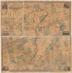
Topographical map of the county of Penobscot Maine
1 : 80000 Walling, Henry Francis, 1825-1888 Lee & Marsh
Penobscot Co., Maine.
1 : 310000 J.H. Stuart & Co.
Penobscot Co., Maine.
1 : 310000 George N. Colby & Co.
Piscataquis Co., Maine.
1 : 316800 J.H. Stuart & Co.
Timber lands 3.
1 : 253440 J.H. Stuart & Co.
Millinocket
1 : 250000
Millinocket
1 : 250000
Millinocket
1 : 250000
Millinocket
1 : 250000
Millinocket
1 : 250000
Millinocket
1 : 250000
Millinocket
1 : 250000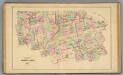
Timber lands 3.
1 : 253440 George N. Colby & Co.
Lincoln
1 : 100000
Lincoln
1 : 100000
An accurate plan of 189,120 acres of land on Penobscot River being the purchase from the Penobscot Indians by government on each side said river together with two gores of land, one on each side
Carleton, Osgood, 1742-1816 s.n.
Bangor
1 : 100000
Bangor
1 : 100000
Map of Piscataquis County Maine
1 : 63360 Walling, Henry Francis, 1825-1888 Lee & Marsh
Timber lands 2.
1 : 253440 J.H. Stuart & Co.
Timber lands 2.
1 : 253440 George N. Colby & Co.
Waldo Co., Maine.
1 : 225000 J.H. Stuart & Co.
Great Pond
1 : 62500
Great Pond
1 : 62500
Great Pond
1 : 62500
Great Pond
1 : 62500
Lead Mountain
1 : 62500
Lead Mountain
1 : 62500
Lead Mtn
1 : 62500
Pittsfield
1 : 62500
Pittsfield
1 : 62500
Stetson
1 : 62500
Stetson
1 : 62500
Stetson
1 : 62500
Bangor
1 : 62500
Bangor
1 : 62500
Bangor
1 : 62500
Orono
1 : 62500
Orono
1 : 62500
Orono
1 : 62500
Orono
1 : 62500
Bangor
1 : 50000
Bangor
1 : 62500
Bangor
1 : 62500
Orono
1 : 62500
Orono
1 : 62500
Orono
1 : 62500
Orono
1 : 62500
Bangor
1 : 62500
Stetson
1 : 62500
Stetson
1 : 62500
Stetson
1 : 62500
Pittsfield
1 : 62500
Pittsfield
1 : 62500
Pittsfield
1 : 62500
Pittsfield
1 : 62500
Pittsfield
1 : 62500
Great Pond
1 : 62500
Great Pond
1 : 62500
Great Pond
1 : 62500
Great Pond
1 : 62500
Lead Mountain
1 : 62500
Lead Mtn
1 : 62500
Lead Mountain
1 : 62500
Lead Mountain
1 : 62500
Lead Mountain
1 : 62500
Stetson
1 : 48000
Pittsfield
1 : 48000
Great Pond
1 : 48000
Lead Mountain
1 : 48000
Bangor
1 : 62500
Bangor
1 : 62500
Bangor
1 : 62500
Bangor
1 : 62500
Bangor
1 : 62500
Bangor
1 : 62500
Orono
1 : 62500
Orono
1 : 62500
Orono
1 : 62500
Orono
1 : 62500
Orono
1 : 62500