Maps of Algeria
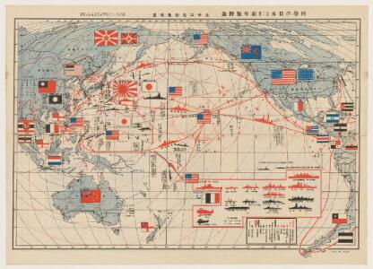
太平洋攻防戰略圖.
Supplement of 科學の日本, 第1卷, 第3號, 新年號." On verso: 世界五大海軍代表艦型一覽圖
天下輿地圖:天下圖
天下輿地圖 明清时期 该图集为李氏朝鲜时期舆图,前有《天下圖》和《中國圖》各一幅,后为朝鲜八道图及日本图。封面题有“玄黓執徐腊下瀚”,可能是壬辰年十二月下旬,但具体年份待定。内容与形态基本与上图相同(005833853),《天下圖》反映中国传统天下观,中国居中,周围岛国取自《山海经》,《中國圖》绘制明朝两京十三省。 1图,彩绘,中文,图幅27.8 x 34.3 cm。 Harvard-Yenching | Rare Book | TK 3490.7 1174;Hollis Number:009140732
Frankreich.
1 : 3000000 Andree, Richard

167-168. Africa, West. The World Atlas.
1 : 7500000 USSR (Union of Soviet Socialist Republics).
Africa NW.
1 : 10000000 Andree, Richard; Times (London, England)
France, Spain, and Portugal.
1 : 3650000 Johnson, A.J.
France, Spain, and Portugal.
1 : 3658000 Johnson, A.J.

Carte generale de toute l'Europe, 4
1 Blatt : 56 x 48 cm J.M. Will
Algérie
1 : 3500000 Alžírsko Gouvernement général de l'Algérie, Service cartographique
Algérie
1 : 3500000 Alžírsko Gouvernement général de l'Algérie, Service cartographique
Podrobná politická mapa Evropy
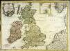
Carte des isles Britanniques contenant les royaumes d'Angleterre, d'Ecosse, d'Irlande et isles dépendantes
1 Karte : Kupferdruck ; 53 x 72 cm Flink; Mondhare chés Mondhare rue St. Jacques
France, Spain, and Portugal.
1 : 3650000 Johnson, A.J.
France, Spain, and Portugal.
1 : 3650000 Johnson, A.J.
Gallia Antiqua.
1 : 5500000 Anville, Jean Baptiste Bourguignon d, 1697-1782
Jak vzniká mapa
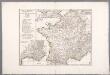
Gallia Antiqua ex aevi Romani monumentis eruta, et serenissimi Carnutum ducis munificentia publici juris facta / auctor d'Anville ; [gravé par] De-la-Haye
1 : 2500000 Annotatie: Met lijst van Romeinse provincies: I-XVII; In: [Atlas du Sr. d'Anville], bl. 7; Annotatie geografische gegevens: Met schaalstokken Jean-Baptiste Bourguignon d' Anville 1697-1782; Guillaume Nicolas Delahaye 1727-1802 [Paris : apud auctorem]
Frankreich nach der alten und neuen Eintheilung
1 Karte : Kupferdruck ; 28 x 24 cm Sotzmann; Jättnig s.n.
Neue Orientierungkarte [von] Frankreich u[nd] Mittelmeerlä[nder]
Francie
Western Europe.
1 : 7303000 Fisher, Richard Swainson
Russian Empire.
1 : 21000000 Greenleaf, Jeremiah
Russian Empire.
1 : 21000000 Greenleaf, Jeremiah
[XII], uit: Geognostische Karte des Oesterreichischen Kaiserstaates mit einem grossen Theile Deutschland's u. Italien / hauptsachlich nach ... Haidinger's geognostischer Karte dieses Staates bearb. von Josef Scheda
1 : 3000000 titelvariant: General-Karte von Europa in 25 Blättern; Annotatie: Bijlage bij: General-Karte von Europa in 25 Blättern. - 1:2.592.000. - 1845-1847 Scheda, Joseph Wien : K.K. Militär. Geografisch. Institut
France.
from A new systeme of the mathematicks: containing I. Arithmetick, as well natural and decimal, as in species, or the principles of algebra. II. Practical geometry, together with the first six books of Euclid's Elements, as also the eleventh and twelfth, symbo
30-31. Francia, France.
1 : 3000000 Touring club italiano
[Karte von dem Deutschen Meere und den ängränzenden Theilen des Atlantischen Oceans. Zur Übersicht der Fluthwellen und der Beschaffenheit des Seebodens]
Erster Band, enthaltend in vier Abtheilungen die Erscheinungen der anorganischen Natur: 1. Meteorologie und Klimatographie. 2. Hydrologie und Hydrographie. 3. Geologie. 4. Tellurischer Magnetismus Humboldt, Alexander von Verlag von Justus Perthes
L'Espagne
1 Karte : Kupferdruck ; 47 x 59 cm L'Isle; Luchtenburg; Silva chez I. Covens et C. Mortier