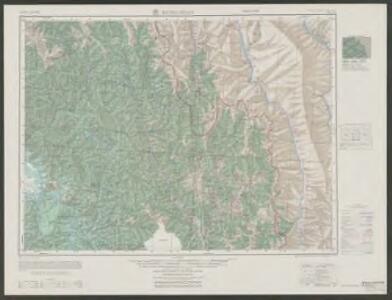
Maps of Machanbaw Township

Kung-shan
1 : 2500000 United States. Army Map Service. Army Map Service
Fu-kung
1 : 2500000 United States. Army Map Service. Army Map Service
Wei-hsi
1 : 2500000 United States. Army Map Service. Army Map Service
Partie, la Chine. Asie 85.
1 : 1641836 Vandermaelen, Philippe, 1795-1869
Iunnan Imperii Sinarum Provincia Decimaquinta. [Karte], in: Novus atlas absolutissimus, Bd. 11, S. 219.
1 Karte aus Atlas Janssonius Offizin
Iunnan Imperii Sinarum Provincia Decimaquinta. [Karte], in: Novus atlas Sinensis, S. 221.
1 Karte aus Atlas Martini, Martino Blaeu, Joan
Suchuen, Imperii Sinarum Provincia Sexta. [Karte], in: Novus atlas absolutissimus, Bd. 11, S. 100.
1 Karte aus Atlas Janssonius Offizin
Burma, OR 5574
One sheet within a four-sheet series, OR 5574, that contains both color and monochrome maps. Great Britain. War Office. [London] : [War Office]
滿洲支那全土明細地圖‧ 西南支の部
1 : 4000000 滿洲支那全土明細地圖‧西南支の部‧廣東附近 (南支ノ部) 昭和十三年[1938]11月15日,アトラス社 制图,东京:讀賣新聞社 发行 讀賣新聞社发行的这套《滿洲支那全土明細地圖》按地区分为8幅图,此图一面为《西南支の部》,即西南地区地图,包括川、陕、云、贵以及甘肃南部、青海东部、西康东部、广西西部等地区,比例尺1:4,000,000,经纬度约为E96°-110°; N22°-38°。另一面为《廣東附近 (南支ノ部)》,即华南地区图,包括广东和福建、江西、湖南等三省的南部,比例尺1:2,000,000,经纬度约为E110°-120°; N21°-27°。两图都在分层设色地形图上标注了详细的村镇地名。 插图1幅《海南島》,为海南岛地形图。 2图,彩色,日文,图幅51 x 36 cm,比例尺和经纬度范围各异。 Harvard-YenchingManchuguo J-0833;Hollis Number:014624010 アトラス社
Suchuen, Imperii Sinarum Provincia Sexta. [Karte], in: Novus atlas Sinensis, S. 102.
1 Karte aus Atlas Martini, Martino Blaeu, Joan
India - north-eastern section.
1 : 4000000 John Bartholomew & Co.
Iunnan, Queicheu, Quangsi, et Quantung, Provinciae Regni Sinensis, Praefecturae dictae. hoc est Meridiem inter et Occidentalis sitae. [Karte], in: Novus atlas absolutissimus, Bd. 6, S. 133.
1 Karte aus Atlas Janssonius Offizin
[Undecima Asie tabula] [Karte], in: Clavdii Ptholomei Viri Alexandrini Cosmographie, S. 188.
1 Karte aus Atlas Nicolaus Germanus [und Ptolemaeus, Claudius]
India, East including Burma (Myanmar), Siam (Thailand), and French Indo-China (Vietnam).
1 : 6997000 Hammond, C.S.
Inde N.-E. et Tibet.
1 : 5000000 Vivien St Martin, L.
Burmah, Siam, Cochin China.
1 : 4600000 Arrowsmith, John
Undecima Asie Tabula [Karte], in: [Clavdii Ptholomei Cosmographi ...], S. 332.
1 Karte aus Atlas Nicolaus Germanus [und Ptolemaeus, Claudius]
Burmah, Siam, and Cochin China.
1 : 4500000 Arrowsmith, John
Suchuen; et Xenxi, Provinciae seu Praefecturae Regni Sinensis, Versus Caurum id est inter Occidentem et Septentrionem sitae. [Karte] , in: Novus atlas absolutissimus, Bd. 6, S. 130.
1 Karte aus Atlas Janssonius Offizin
117-118. China, Central and South. The World Atlas.
1 : 5000000 USSR (Union of Soviet Socialist Republics).
REGNI SINAE vel SINAE PROPRIAE Mappa et Descriptio Geographica
1 : 5400000 Čína východní Hase, Johann Matthias Anville, Jean-Baptiste Bourguinon d' impensis Homan[n]ianorum Heredum
REGNI SINAE vel SINAE PROPRIAE Mappa et Descriptio Geographica
1 : 5400000 Čína východní Hase, Johann Matthias Anville, Jean-Baptiste Bourguinon d' impensis Homan[n]ianorum Heredum
Regni Sinae vel Sinae propriae mappa et descriptio geographica
1 : 5420000 Čína východní Hase, Johann Matthias Anville, Jean-Baptiste Bourguinon d' Homannianos Heredes
Siam, Burma & Anam.
1 : 6969600 Stanford, Edward
Hinterindien
1 : 4000000 dem Sir Francis Hamilton [...] gewidmet vom Verfasser [H. Berghaus] gest. von W. Brose Gotha : Perthes
HINTERINDIEN
1 : 4000000 Kambodža Berghaus, Heinrich Karl Wilhelm Brose, W. Justus Perthes
Entwurf des Birmanschen Reichs
Kambodža Dalrymple
Di-gyiu Du, Ng Da-tsiu Di-du[地舆图、五大洲地图]
Di-gyiu Du, Ng Da-tsiu Di-du[地舆图、五大洲地图] 1853年,Martin, W. A. P. (William Alexander Parsons) 美国长老会传教士丁韪良用罗马拼音标注宁波方言编写的世界地理著作,对地球和各大洲进行介绍。内有东西半球图、亚洲图、欧洲图、非洲图、北美洲图、南美洲图、地中海附近图、清内地十八省图、浙江省图、宁波附近图等。 10图,墨刻本,罗马拼音标注宁波方言,图幅不一,约39 x 49.5 cm Harvard-Yenching | Rare Book | TA 2370 92,Hollis Number:008156153
Tabula Asiae XI. [Karte], in: Geographia universalis vetus et nova complectens Claudii Ptolemaei Alexandrini enarrationis libros VIII, S. 296.
1 Karte aus Atlas Münster, Sebastian [und Ptolemaeus, Claudius]