Maps of Mediterranean Sea

Di-gyiu Du, Ng Da-tsiu Di-du[地舆图、五大洲地图]
Di-gyiu Du, Ng Da-tsiu Di-du[地舆图、五大洲地图] 1853年,Martin, W. A. P. (William Alexander Parsons) 美国长老会传教士丁韪良用罗马拼音标注宁波方言编写的世界地理著作,对地球和各大洲进行介绍。内有东西半球图、亚洲图、欧洲图、非洲图、北美洲图、南美洲图、地中海附近图、清内地十八省图、浙江省图、宁波附近图等。 10图,墨刻本,罗马拼音标注宁波方言,图幅不一,约39 x 49.5 cm Harvard-Yenching | Rare Book | TA 2370 92,Hollis Number:008156153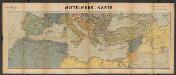
Metzer karten der Mittelmeer Raum
1 : 5950000 Metzer Verlagsanstalt Metz : Metzer Verlagsanstalt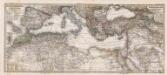
Composite: Mittellandische Meer, Nord-Afrika.
1 : 7500000 Petermann, A.
Das Mittellandische Meer Und Nord-Afrika.
1 : 7500000 Petermann, A.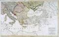
Carte generale de toute l'Europe, 3
2 Blätter : 56 x 90 cm J.M. Will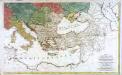
Carte générale de toute l'Europe, 2
2 Blätter : 57 x 93 cm T.C. Lotter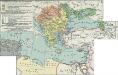
II. Rückgang des Osmanischen Reichs (Orientalische Frage) seit 1683
1 : 28000000 Osmanisches Reich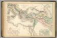
Principal Countries of the Ancient World.
1 : 7100000 Hughes, William
Carte patriculiére des pais ou les apôtres ont preché l'euangile, des lieux les plus renommez de leurs voyages, et de la route de St. Paul a Rome
Středozemní moře-oblast Luchtenburg, I. van Mortier, Pieter Pierre Mortier
Karte der griechischen Welt
Evropa jižní F. Tempsky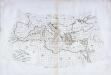
Carte des pays qu'occupe maintenant la mer Mediterranée
1 Karte : Kupferdruck ; 32 x 66 cm La Borde s.n.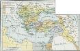
Osmanisches Reich bis 1683
1 : 18000000 Osmanisches Reich Expansion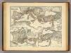
Mare internum cum populis adiacentibus a Pompeii ex Asia reditu usque ad bellum Actiacum.
1 : 12000000 Menke, Th.
I. Osmanisches Reich bis 1683
1 : 28000000 Osmanisches Reich Expansion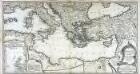
Theatre de la guerre entre les Russiens et les Turcs
1 Karte auf 2 Blatt : Kupferdruck ; 50 x 93 cm Roth C. M. Roth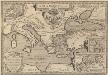
Argonautica. [Karte] [Europa.], [Thessalia und Umgebung], [Hellespontus, Phryxeum aequor, et Athamantidis fluenta.] [3 Nebenkarten], in: Theatrum orbis terrarum, S. 538.
1 Karte aus Atlas Ortelius, Abraham Vrients, Jan Baptista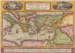
Peregrinationis Divi Pauli Typus Corographicus [...] [Karte], in: Theatrum orbis terrarum, S. 442.
1 Karte aus Atlas Ortelius, Abraham
Geographische beschryvinghe van de wandeling der apostelen ende de reysen Pauli, : mitsgaders de landen ende rijcken daer sij het Evangelium eerst hebben verkondight, / nieuwlijcx int licht gebracht door Nicolaes Visscher ; A. vanden Broeck sculp
1 : 7000000 Annotatie: Kaart van het oostelijk deel van de Middellandse Zee, omringd door 9 gravures van de reizen van Paulus; Rechtsonder genummerd: 6; Origineel is Blad 184 in atlas factice; Annotatie geografische gegevens: Met 2 schaalstokken Nicolaes Jansz Visscher sr 1618-1679; Abraham van den Broeck ca. 1616-1688 [Amsterdam : Nicolaas Visscher]
A new map of Turky in Europe and parts adjoyning shewing their principal divisions and chief cities, towns, rivers, mountains &c.
from A new sett of maps both of antient and present geography : wherein not only the latitude and longitude of many places are corrected according to the latest observations, but also the most remarkable differences of antient and present geography may be quickly discern'd by a bare inspection or comparing of correspondent maps, which seems to be the most natural and easy method to lead young students (for whose use the work is principally intended) unto a competent knowledge of the geographical science : together with a geographical treatise particularly adapted to the use and design of these maps / by Edward Wells, M.A. and student of Christ-Church, Oxon.
Osmanisches Reichs.
1 : 11800000 Radefeld, Carl Christian Franz, 1788-1874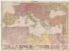
Mittelmeerländer
1 : 4000000 Afrika severní Georg Westermann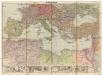
Mittelmeerländer
1 : 4000000 Afrika severní Georg Westermann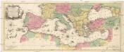
Carte geographique representant la Mer Mediterranée ou la seconde partie du théatre de la guerre entre les Russes et les Turcs
1 : 1000000 Evropa jižní Lotter, Tobias Conrad Tobie Conrad Lotter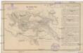
Das türkische Reich
Afrika severní
Türkey
Allgemeiner Atlas [Walch, Johannes] im Verlag bei Johannes Walch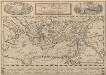
Peregrinationis Divi Pauli Typus Corographicus. [...] [Karte], in: Theatrum orbis terrarum, S. 441.
1 Karte aus Atlas Ortelius, Abraham Vrients, Jan Baptista
Das osmannische Reich, XVIIten Jahrhundert.
1 : 9200000 Spruner von Merz, Karl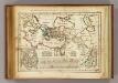
Regions, lieux dans le Nouveau Testament.
1 : 18000000 Delamarche, Charles Francois
(Mediterranean Region)
1 : 10900000 Bowen, Frances
![Di-gyiu Du, Ng Da-tsiu Di-du[地舆图、五大洲地图]](https://images-2.georeferencer.com/images/iiif/728658724674/full/,300/0/native.jpg)

