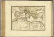
Maps of Mediterranean Sea
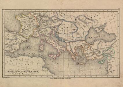
Europa und das oström. Reich zur Zeit der Kreuzzüge
Europa, Byzantinisches Reich, Kreuzzüge
Map of the Austrian Empire, Italian States, Turkey in Europe, and Greece ; Maltese Islands [inset]
from New general atlas.
[Historisch-geographischer Atlas zu den allgemeinen Geschichtswerken von C. v. Rotteck, Pölitz u. Becker] : Die Küsten des Mittelländischen Meeres zur Uebersicht der ältesten Kolonisationen
von Julius Loewenberg [Freiburg im Breisgau] : [Herder]

Europa Temporibus Expeditionum Sacrarum
Europa Kreuzzüge
Overland Route To India.
1 : 24000000 Tallis, J. & F.
Europa Aetate Napoleontis I
Europa Napoleon I., Frankreich, Kaiser
Evropa za stěhování národů
Mapa de la Conca Mediterrània: principals infrastructures de transport : regions europees riberenques de la Mediterrània
1 : 3500000 1 Mapa. Institut Cartogràfic de Catalunya ICC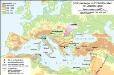
Südosteuropa im Frühmittelalter mit Jireček-Linie
Südosteuropa Sprachgeografie Zwick, J.
Das künftige Wien als Verkehrs-Centrum von Europa
Österreich, Wien, Verkehrsknotenpunkt Hahn, Johann Georg von
Paasche's Frontenkarte, Nr. 11 Europäische Kriegsschauplätze

Napoleons Heereszüge : von seinem Auftreten als Ober-General der Armee von Italien 1796 bis zu seiner Thron-Entsagung nach der Schlacht bey Waterloo 1815
Entworfen von F.W. Benicken gravirt v. C. Halle Weimar : im Verlage des Landes Industrie-Comptoirs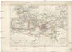
Das Römische Reich unter Traianus
starověký Řím
Tableau historique de Rome ancienne.
1 : 23700000 Duval, Henri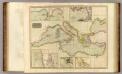
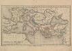
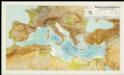
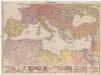
Mediterranean Sea.
1 : 6300000 Thomson, John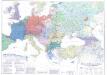
Länder- und Völkerkarte Europas
1 : 4000000 Europa Volk Staat Geschichte Schäfer, Dietrich
Říše římská v době největší své rozsáhlosti
Théatre de la guerre actuelle, en Allemagne, en Pologne et en Turquie. Carte de l'Europe méridionale en 53 feuilles qui se réunissent. Tableau d'assemblage indiquant la disposition de ces feuilles, pour en faciliter la réunion
1 : 28500000 Chanlaire, Pierre Grégoire 1758-1817 Paris : chez l'auteur P. G. Chanlaire
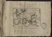
Carte nouvelle de la mer Mediterranée : divisée en mer de Levant et de Ponant, subdivisés en leurs principales parties ou mers : avec les observations des Mrs. de l'Académie
1 : 4375000 Sanson, Nicolas, 1600-1667 chez Pierre Mortier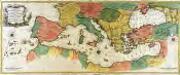
Carte geographique representant la mer Mediterranée ou la seconde partie du théatre de la guerre entre les Russes et les Turcs
1 Karte auf 3 Blättern : Kupferdruck ; 53 x 130 cm Lotter Tobias Konrad Lotter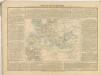
Mittelmeerländer
1 : 4000000 Afrika severní Georg Westermann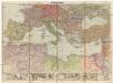
Mittelmeerländer
1 : 4000000 Afrika severní Georg Westermann
Kriegszusammenhänge II (1672-1699)
1 : 25000000 Europa Englisch-Niederländischer Seekrieg <1672-1674>, Türkenkriege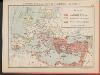
L'Empire Grec au temps de Justinien (VI.e siècle)
Byzantinisches Reich Justinian I.
Europa beim Beginn der französischen Revolution. 1789
Europa Französische Revolution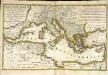
Mare Mediterranevm
1 Karte : Kupferdruck ; 37 x 59 cm Hauer Homännische Erben