Maps of Balkan Pen.

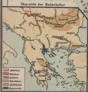
Übersicht der Bodenkultur
Osmanisches Reich / Europäischer Teil, Griechenland, Bodennutzung
Die Balkanländer
1 : 1700000 Dardanely (Turecko : průliv) Carl Flemming
Türkei und Griechenland.
1 : 5000000 Osmanisches Reich / Europäischer Teil, Griechenland
Die Europaeische Türkei, Griechenland und die Jonischen Inseln
E. von Sydow's Schul-Atlas in sechs und dreissig Karten Sydow, Emil von bei Justus Perthes
Der Europäische Theil des Osmanischen Reichs oder die Europäische Türkey
Stieler's Hand-Atlas Stieler, Adolf bei Justus Perthes
Das Osmanische Reich in Europa, Griechenland und die Jonischen Inseln
Schul-Atlas über alle Theile der Erde nach dem neuesten Zustande, und über das Weltgebäude Stieler, Adolf Justus Perthes
Die E. Türkei Griechenland und die Ionischen Inseln
Jónské ostrovy (Řecko)
Carte generale de la Turquie d'Europe a la droite du Danube ou des beglerbegliks de Roum Ili, Bosna et Moree
1 : 1300000 Dardanely (Turecko : průliv) Vaudoncourt, Guillaume de Reinhard, Carl Depôt geographique
Balkan-Halbinsel, politische Übersicht
1 : 6000000 Balkanhalbinsel
Die Europäische Türkey, Griechenland und die Jonischen Inseln
Schul-Atlas über alle Theile der Erde nach dem neuesten Zustande, und über das Weltgebäude Stieler, Adolf bei Justus Perthes
Balkan-Halbinsel, Flusz- & Gebirgskarte
1 : 6000000 Balkanhalbinsel
Südosteuropäische Halbinsel, Geologische Übersicht
Südosteuropa
Anbau und Januar-Isothermen
Balkanhalbinsel Pflanzenbau, Klima
Die EuropaeischeTuerkey, Griechenland und die Jonischen Inseln
Osmanisches Reich / Europäischer Teil, Griechenland
Ethnog. Balkan Peninsula, Constantinople, Sea of Marmara.
1 : 6000000 Andree, Richard; Times (London, England)
Balkanhalbinsel
1 : 5000000 Balkánský poloostrov F. A. Brouckaus' Geogr.-artist. Anstalt

[Ethnographische Karte des Osmanischen Reichs europäischen Theils und von Griechenland]
Zweiter Band, enthaltend in vier Abtheilungen die Vertheilung der Organismen: 5. Pflanzen-Geographie, 6. Thier-Geographie, 7. Anthropographie, 8. Ethnographie Humboldt, Alexander von Verlag von Justus Perthes
Evropské Turecko, Černá Hora, Řecko a Jonské ostrovy
1 : 3000000 Jónské ostrovy (Řecko) Stojanov, Vasil
Josef v[on] Scheda's General-Karte der Balkan-Halbinsel
1 : 864000 Balkánský poloostrov Steinhauser, Anton Peucker, Karl Artaria
Des Osmanischen Reichs europäischer Theil, Griechenland und die Jonischen Inseln
osmanská říše Stülpnagel, Friedrich von Jättnig, Karl Justus Perthes
H. Kiepert's Generalkarte der südost-europäischen Halbinsel
1 : 1500000 Balkánský poloostrov Bischoff, C. Kiepert, Heinrich Dietrich Reimer
Státy balkánské

Karten zum russisch-türkischen Krieg 1877-1878. Europäische Türkei und Balkanstaaten nach dem Berliner Kongress
1 : 6000000 Balkanhalbinsel Russisch-Türkischer Krieg <1877-1878> , Berliner Kongress
Osmanischen Reichs europ. Theil, Griechenland.
1 : 10200000 Brudin, J. L.; Stieler, Adolf
Graecia nova et mare Aegeum s. Archipelagus, in qua mappa Macedonia, Albania, Epirus, Thessalia et Morea, cum circumjacentibus insulis Corcyra, Cephalonia, Zacynthos, Stalimene, Metelino, Chios, distinctae exhibentur
1 : 1660000 Achaia (Řecko) Lotter, Tobias Conrad sumtibus Tobiae Conradi Lotteri
Graecia nova et mare Aegeum s. Archipelagus, in qua mappa Macedonia, Albania, Epirus, Thessalia et Morea cum circumjacentibus insulis Corcyra, Cephalonia, Zacynthos, Stalimene, Metelino, Chios, distinctae exhibentur
1 : 1660000 Achaia (Řecko) Lotter, Tobias Conrad sumtibus Tobiae Conradi Lotteri
Turkey in Europe.
1 : 2500000 Arrowsmith, John
Des Osmanischen Reichs europäischer Theil, Griechenland und die Jonischen Inseln
Hand-Atlas über alle Theile der Erde nach dem neuesten Zustande und über das Weltgebäude Stieler, Adolf bei Justus Perthes