Maps of Europe

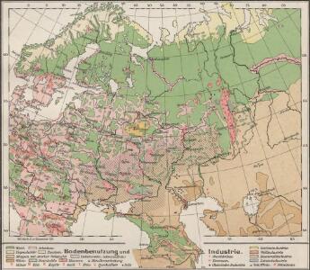
Bodenbenutzung und Industrie
Russland / Europäischer Teil Industrie, Bodennutzung
Russland und Skandinavien
Handatlas über alle Theile der Erde und über das Weltgebäude Stieler, Adolf Justus Perthes
Völkerkarte
Osteuropa Ethnische Gruppe
66-67. Russia.
1 : 7500000 Touring club italiano
Etnografska karta na slavjanstvoto v Evropa
1 : 5000000 Evropa východní Florinskij, Timofej Dmitrijevič Slavjanska besěda
Mapa slovanského světa

Russland beim Tode Iwans II. 1584
Russland
Tabula Russiae ex autographo, quod delineandum curavit Foedor filius Tzaris Boris desumta [...] [Karte], in: Theatrum orbis terrarum, sive, Atlas novus, Bd. 1, S. 67.
1 Karte aus Atlas Blaeu, Joan Blaeu, Willem Janszoon
Russland
1 : 36000000 Russland / Europäischer Teil
Russia cum confiniis. [Karte] Russiae Pars Amphlificata [Nebenkarte], in: Gerardi Mercatoris Atlas, sive, Cosmographicae meditationes de fabrica mundi et fabricati figura, S. 158.
1 Karte aus Atlas Mercator, Gerhard Montanus, Petrus
Composite: Russia, Finland.
1 : 6000000 John Bartholomew and Son
Russland und Skandinavien
Adolf Stieler's Handatlas über alle Theile der Erde und über das Weltgebäude Stieler, Adolf Justus Perthes
Mapa slovanského světa

[Europ. Russland]
[Allgemeiner Atlas über alle Theile der Erde in 29 Blättern] Ziegler, Jakob Melchior Top. Anstalt v. J. Wurster u. Comp.
Soubor němých map pro gymnasia a odborné školy

Europaeisches Russland
Grosser Hand-Atlas über alle Theile der Erde in 170 Karten Meyer, J. Verlag des Bibliographischen Instituts
Russland
Neuer Handatlas über alle Theile der Erde Kiepert, Heinrich Verlag von Dietrich Reimer
Tabula Russiae [...] [Karte] Moscua [Planvedute, [Nebenkarte], in: Novus Atlas, das ist, Weltbeschreibung, Bd. 1, S. 55.
1 Karte aus Atlas Blaeu, Joan Blaeu, Willem Janszoon
Russland und Skandinavien
Hand-Atlas über alle Theile der Erde und über das Weltgebäude Stieler, Adolf Justus Perthes
Europaeisches Russland
Plastischer Schul-Atlas über alle Theile der Erde : in 24 Karten Woldermann, G Verlag von P. Eckerlein
Tabula Russiae ex mandato Foedor Borissovitsj delineata ... Magno domino, Tzari et magno duci Michäeli Foedrowits omnium Russorum autocratori... dedicata a Nicolao Ioannis Piscatore
1 : 10000000 Annotatie: Met breedte- en lengtegraden; Origineel is Blad 136 in atlas factice; Annotatie geografische gegevens: 2 schaalstokken: Wirst seu milliaria Russica en Milliaria Germanica; Inzet: Celeberrima ingens et imperialis civitas Moscua; Russche Narva sive Ivane-gorod; Archangel sive Archangelscka-goroda; Curia Imperatoris Russi appellata Kremelena-gorod; Hypocausta Russorum; Molendina Russorum Fjodor Borissovitsj Godoenov 17e E.; Claes Jansz. Visscher 1586/1587-1652 [S.l. : C.J. Visscher Excudebat]
Russland seit Peters des Grossen Zeit
1 : 12000000 Russland
Europaeisches Russland mit Polen
Geographischer Atlas über alle Theile der Erde Ziegler, Jakob Melchior Verlag von Dietrich Reimer
Ruszland
1 : 12000000 Russland / Europäischer Teil
Novissima Russiæ tabula / authore Isaaco Massa
1 : 8500000 Annotatie: Rechtsboven genummerd: VI; Met opdracht van Hondius aan Isaac Bernart; Origineel is Blad 135 in atlas factice; Annotatie geografische gegevens: Met 2 schaalstokken Isaac Abrahamszoon Massa 1586-1643; Henricus Hondius 1573-1650 [Amsterdam, Londen : apud Janssonio-Waesbergios, et Mosem Pitt]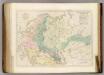
Sketch of the Acquisitions of Russia since the Accession of Peter 1st. to the Throne.
1 : 6969600 Arrowsmith, John
Europaeisches Russland mit Kasan, Astrachan und Georgien
Schul-Atlas über alle Theile der Erde nach dem neuesten Zustande, und über das Weltgebäude Stieler, Adolf Justus Perthes
Europaeisches Russland mit Polen.
1 : 7040000 Ziegler, J. M.
Sarmatische Tiefebene
Osteuropa, Ostmitteleuropa