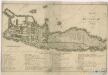
Maps of Finnish Lake Region

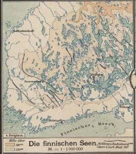
Die finnischen Seen
Finnland Seengebiet
Schema raīona operacīi grafa Kamenskago
Finnland Kamenskij, Nikolaj Michajlowic Russisch-Schwedischer Krieg <1808-1809>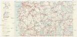
Finnland Straßenkarte
1 : 400000 Finsko Gen St d H Abt f Kr Kart u Verm W IV Mil Geo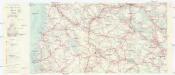
Finnland Straßenkarte
1 : 200000 Finsko Gen St d H Abt f Kr Kart u Verm W IV Mil Geo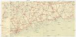
Finnland Straßenkarte
1 : 200000 Finsko Gen St d H Abt f Kr Kart u Verm W IV Mil Geo
Finnische Schärenküste
1 : 2000000 Finnland Schärenküste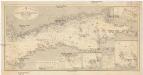
Ostsee
1 : 400000 Baltské moře Reichs-Marine-Amt
Kronstadt, Wiborg, Wesenberg
1 : 750000 Kronštadt (Rusko) K. u. k. Militärgeographisches Institut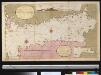
Afteekening van t agterste gedeelte van de Oost Zee van t eijlant Dago tot Schansternij
Gulf of Finland Gerard van Keulen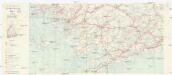
Finnland Straßenkarte
1 : 200000 Finsko Gen St d H Abt f Kr Kart u Verm W IV Mil Geo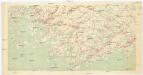
[Suomi tiekartta 1:200 000]
1 : 200000 Finsko
Afteekening van de Oostzee of Oost Finsche Boodem vertoonende de vaart van Revel tot St. Petersburgh int groot
Gulf of Finland Gerard van Keulen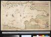
Afteekening van de Finsche Boodem in de Ost Zee of vaarweg van 't Hoogland tot voor St. Petersborgh
Gulf of Finland Gerard van Keulen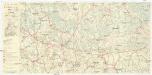
Finnland Straßenkarte
1 : 200000 Finsko Gen St d H Abt f Kr Kart u Verm W IV Mil Geo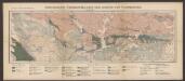
Geologische Übersichtskarte der Gegend von Tammerfors
1 : 400000 Sederholm, J.J. F. Tilgman
Kaart van de Zweedse en Russische krygs-verrigtingen in Finland A° 1788
1 : 155000 P. v. Eeusom jnr. sculp.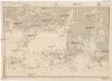
Ostsee
1 : 100000 Baltské moře Reichs-Marine-Amt
Kaart van de krygs-verrigtingen der Zweeden en Russen in Finland A°. 1789
1 : 123000 door Roos
K vojně so Švecīej 1808 - 1809 gg. Karta prochoda okolo ostrova Kimito
Finnland Kimito Seeschlacht Russisch-Schwedischer Krieg <1808-1809>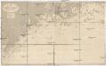
Ostsee
1 : 50000 Baltské moře Reichs-Marine-Amt
Schema k dějstvījam u Ganguta v ījulě 1714 g.
Finnland Hanko Nordischer Krieg <1700-1721>
Ostsee
1 : 50000 Baltské moře Reichs-Marine-Amt
Ostsee
1 : 50400 Baltské moře Reichs-Marine-Amt
Uudenmaan ja Wiipurin läänit
1 : 50000 Maanmittaushallituksen kivipaino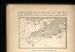
Proryv galernago flota 26 ījulja 1714 goda.
Ostsee Nordischer Krieg <1700-1721> Seeschlacht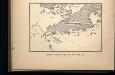
Proryv galernago flota 27 ījulja 1714 goda.
Ostsee Nordischer Krieg <1700-1721> Seeschlacht
Kr. Sveaborg i okrestnosti putej vokrug Gel'singforsa
Finnland Suomenlinna Russisch-Schwedischer Krieg <1808-1809>
Etelä-Pirkkala
1 : 20000 Maanmittaushallituksen kivipaino
PLAN von KRONSTADT
1 : 27000 Kronštadt (Rusko)