Maps of Balkan Pen.
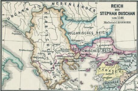
Reich des Stephan Duschan
1 : 10000000 Serbien Stefan Dušan, Srbija, Car
Die von den Balkanstaaten bis Ende April 1913 besetzten Gebiete
Südosteuropa, Osmanisches Reich, Balkankriege Häusler, Ines
Règions occupèes par les belligèrants fin avril 1913
Südosteuropa Balkankrieg <1912-1913> Besetzte Gebiete
Carte de la Turquie d'Europe
Balkánský poloostrov Boué, A. Avril, Ch. chez Arthus-Bertrand
Ethnographische Karte von Europäischen Türkei...

Das Zweite Bulgarische Reich (1087-1256 n. Chr.)
Bulgarien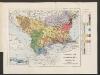
Ethnographische Karte der europäischen Türkei und ihrer Dependenzen zu Anfang des Jahres 1877
Südosteuropa Ethnische Gruppe Sax, Carl
Carte de la Turquie d'Europe
Balkánský poloostrov Boué, A. Arthus-Bertrand chez Arthus-Bertrand
Die Balkanländer
1 : 1700000 Dardanely (Turecko : průliv) Carl Flemming
Graecia nova et mare Aegeum s. Archipelagus, in qua mappa Macedonia, Albania, Epirus, Thessalia et Morea, cum circumjacentibus insulis Corcyra, Cephalonia, Zacynthos, Stalimene, Metelino, Chios, distinctae exhibentur
1 : 1660000 Achaia (Řecko) Lotter, Tobias Conrad sumtibus Tobiae Conradi Lotteri
Graecia nova et mare Aegeum s. Archipelagus, in qua mappa Macedonia, Albania, Epirus, Thessalia et Morea cum circumjacentibus insulis Corcyra, Cephalonia, Zacynthos, Stalimene, Metelino, Chios, distinctae exhibentur
1 : 1660000 Achaia (Řecko) Lotter, Tobias Conrad sumtibus Tobiae Conradi Lotteri
Turkey in Europe.
1 : 3000000 Colton, G.W.
L'église catholique dans les Balkans
1 : 1850000 [Lyon : Oeuvre de la propagation de la foi]
Türkei und Griechenland.
1 : 5000000 Osmanisches Reich / Europäischer Teil, Griechenland
Grenzen Herbst 1913
Südosteuropa Osmanisches Reich Grenze Balkankrieg <1912-1913>
Karten zum russisch-türkischen Krieg 1877-1878. Europäische Türkei und Balkanstaaten nach dem Berliner Kongress
1 : 6000000 Balkanhalbinsel Russisch-Türkischer Krieg <1877-1878> , Berliner Kongress
Das Osmanische Reich in Europa, Griechenland und die Jonischen Inseln
Schul-Atlas über alle Theile der Erde nach dem neuesten Zustande, und über das Weltgebäude Stieler, Adolf Justus Perthes
Carte generale de la Turquie d'Europe a la droite du Danube ou des beglerbegliks de Roum Ili, Bosna et Moree
1 : 1300000 Dardanely (Turecko : průliv) Vaudoncourt, Guillaume de Reinhard, Carl Depôt geographique
Übersicht der Bodenkultur
Osmanisches Reich / Europäischer Teil, Griechenland, Bodennutzung
Die Europäische Türkey, Griechenland und die Jonischen Inseln
Schul-Atlas über alle Theile der Erde nach dem neuesten Zustande, und über das Weltgebäude Stieler, Adolf bei Justus Perthes
Karten zum russisch-türkischen Krieg 1877-1878. Europäische Türkei und Balkanstaaten bis zum Kriegsende
1 : 6000000 Balkanhalbinsel Russisch-Türkischer Krieg <1877-1878>
Grenzen vor dem Kriege
Südosteuropa Osmanisches Reich Grenze
Die Europaeische Türkei, Griechenland und die Jonischen Inseln
E. von Sydow's Schul-Atlas in sechs und dreissig Karten Sydow, Emil von bei Justus Perthes
Die EuropaeischeTuerkey, Griechenland und die Jonischen Inseln
Osmanisches Reich / Europäischer Teil, Griechenland
Balkanhalbinsel
1 : 5000000 Balkánský poloostrov F. A. Brouckaus' Geogr.-artist. Anstalt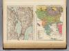
Ethnog. Balkan Peninsula, Constantinople, Sea of Marmara.
1 : 6000000 Andree, Richard; Times (London, England)
Karte der Balkan-Halbinsel und der angrenzenden Gebiete / nach den neuesten Quellen bearb. von Gustav Freytag
1 : 1600000 Annotatie: Met administratieve indeling van het Koninkrijk Griekenland; Annotatie geografische gegevens: Inzetkrt.: Insel Kreta (Candia) Gustav Freytag [S.l. : A. Hartleben's Verlag]
Die Europäische Türkei
Handatlas über alle Theile der Erde und über das Weltgebäude Stieler, Adolf Justus Perthes
Turkey
1 : 12330000 Turecko Walker, C. Baldwin & Cradock