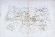
Maps of Mediterranean Sea

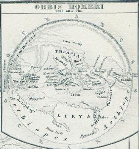
Orbis Homeri. 900? Ante Chr.
Mittelmeerraum Homerus
A new map of Turky in Europe and parts adjoyning shewing their principal divisions and chief cities, towns, rivers, mountains &c.
from A new sett of maps both of antient and present geography : wherein not only the latitude and longitude of many places are corrected according to the latest observations, but also the most remarkable differences of antient and present geography may be quickly discern'd by a bare inspection or comparing of correspondent maps, which seems to be the most natural and easy method to lead young students (for whose use the work is principally intended) unto a competent knowledge of the geographical science : together with a geographical treatise particularly adapted to the use and design of these maps / by Edward Wells, M.A. and student of Christ-Church, Oxon.
Argonautica. [Karte] [Europa.], [Thessalia und Umgebung], [Hellespontus, Phryxeum aequor, et Athamantidis fluenta.] [3 Nebenkarten], in: Theatrum orbis terrarum, S. 538.
1 Karte aus Atlas Ortelius, Abraham Vrients, Jan Baptista

Imperium Romanum Antiquum
Römisches Reich
Osmanisches Reichs.
1 : 11800000 Radefeld, Carl Christian Franz, 1788-1874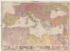
Mittelmeerländer
1 : 4000000 Afrika severní Georg Westermann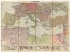
Mittelmeerländer
1 : 4000000 Afrika severní Georg Westermann
A map of the eastern part of the Roman empire
1 Karte : Kupferdruck ; 39 x 42 cm s.n.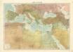
Středomoří
Nord de l'Afrique, Mer Mediterranee, Europe Meridionale.
1 : 9300000 Picquet, C.
[Das Mittellaendische und Schwarze Meer, Auch als General Karte des Osmanischen Reichs]
Hand-Atlas über alle Theile der Erde nach dem neuesten Zustande und über das Weltgebäude Stieler, Adolf bei Justus Perthes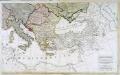
Carte generale de toute l'Europe, 3
2 Blätter : 56 x 90 cm J.M. Will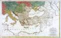
Carte générale de toute l'Europe, 2
2 Blätter : 57 x 93 cm T.C. Lotter
Karte der griechischen Welt
Evropa jižní F. Tempsky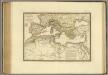
Nord de l'Afrique, Mer Mediterranee, Europe Meridionale.
1 : 9300000 Brue, Adrien Hubert, 1786-1832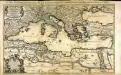
La mer Mediterranée
1 Karte auf 2 Blatt : Kupferdruck ; 53 x 86 cm Sanson; Jaillot chez H. Iaillot joignant les grands Augustins aux 2 Globes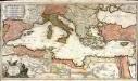
La mer Mediterranée
1 Karte auf 2 Blatt : Kupferdruck ; 47 x 85 cm Valck par G. Valck sur le Dam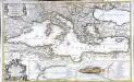
La mer Mediterranée
1 Karte auf 2 Blättern : Kupferdruck ; 53 x 87 cm Sanson; Denis; Basset; Basset chès Basset rue St. Jacques au coin de celle des Mathurins à l'Image S.e Genevieve
Tableau historique de Rome ancienne.
1 : 23700000 Duval, Henri
Mediterranean, Black Sea cables, wireless stations.
1 : 13000000 Philip, George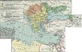
II. Rückgang des Osmanischen Reichs (Orientalische Frage) seit 1683
1 : 28000000 Osmanisches Reich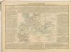
Geschäftsverbindungen und Kupferhandel der Medici 1393-1395
Europa Medici, Bankiers, Fuersten, Italien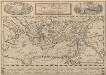
Peregrinationis Divi Pauli Typus Corographicus. [...] [Karte], in: Theatrum orbis terrarum, S. 441.
1 Karte aus Atlas Ortelius, Abraham Vrients, Jan Baptista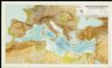
Mapa de la Conca Mediterrània: principals infrastructures de transport : regions europees riberenques de la Mediterrània
1 : 3500000 1 Mapa. Institut Cartogràfic de Catalunya ICC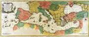
Carte geographique representant la mer Mediterranée ou la seconde partie du théatre de la guerre entre les Russes et les Turcs
1 Karte auf 3 Blättern : Kupferdruck ; 53 x 130 cm Lotter Tobias Konrad Lotter
Turkey, in Europe and Hungary, from the best authorities.
from Carey's general atlas, improved and enlarged : being a collection of maps of the world and quarters, their principal empires, kingdoms, &c.
Turquie in Europe.
from A new systeme of the mathematicks: containing I. Arithmetick, as well natural and decimal, as in species, or the principles of algebra. II. Practical geometry, together with the first six books of Euclid's Elements, as also the eleventh and twelfth, symbo