Maps of Macedonia
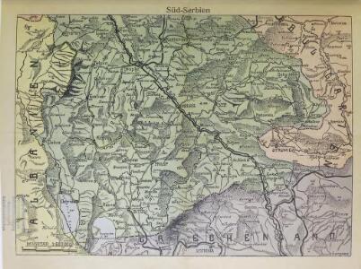
Süd-Serbien
1 : 800000 Serbien (Süd)
Demarkationslinie vor Beginn der Kriege gegen die Bulgaren
Südosteuropa Balkankrieg <1912-1913> Grenze
Ligne de partage d'après la carte annexée au traité d'alliance
Balkanhalbinsel Grenze Balkankrieg <1912-1913> Annexion
Ligne de partage d'après la carte annexée au Traité d'Alliance
Bulgarien Serbien Balkankrieg <1912-1913> Territorialer Anspruch Th. Weinreb del.
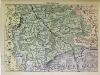
Vormarsch der 1. Armee nach der Schlacht bei Kumanowo bis zur Schlacht bei Bitolj (Monastir)
Makedonien Balkankrieg <1912-1913> Kumanovo / Schlacht
Westliches Mazedonien
1 : 600000 Makedonien (Landschaft)
Karta okresnostej Ochridskago i Prespanskago ozer
Ohrid-oblast (Makedonie) Grigorowič
Kriva Palanka
1 : 200000 Kriva Palanka (Makedonie) Militärgeographisches Institut
Stellungen der Armeen nach der Schlacht an der Bregalnica
Makedonien Bregalnica-Gebiet Balkankrieg <1912-1913>
Bitolj
1 : 200000 Bitola (Makedonie) Kartografska radionica
Vodena
1 : 200000 Kartografska radionica
Plan grada Skoplja
1 : 7500 Skopje (Makedonie) Zadužbinska štamparija Vardarske Banovine Nemanja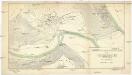
Stereophotogrammetrische Aufnahme des Treskatales (Neuserbien) im Jahre 1914
1 : 2000 Makedonie Konsortium Luftbild, Stereographik
[Bălgarska zemja v Makedonija]
Makedonien Ethnische Gruppe Bulgaren
[Mazedonien]
Makedonien
Izvod ot etnografskata karta na Ležana
Makedonien Ethnische Gruppe
Izvod ot etnografskata karta na Mekenzi i Erbi
Makedonien Ethnische Gruppe
H.8. Skoplje, uit: [Übersichtskarte von Europa 1:750.000]
1 : 750000 Wien : K.u.K. Militärgeographisches Institut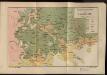
Etnografska karta na Makedonija
Makedonien Ethnische Gruppe
Carte ethnographique de la Macédoine, Point de vue bulgare
Makedonien Ethnische Gruppe Th. Weinreb del.
[Mazedonien]
Makedonien
Carte ethnographique de la Macédoine, Point de vue serbe
Makedonien Ethnische Gruppe Th. Weinreb del.
Carte de la Macédoine d'une partie de l'Albanie, de l'Epire et de la Thessalie
1 : 800000 Albánie Lapie, Pierre Kaeppelin Société geologique de France
Karta Nove Srbije
1 : 1200000 Serbien Makedonien Bukarest / Friede <1913> Staatsgrenze Lazić, Ant.
Karte der Flußgebiete des Drin und des Wardar
1 : 500000 Vardar-Gebiet Flusssystem Hahn, Johann Georg von
Der von der IMRO geplante Mazedonische Staat
Makedonien Innere Makedonische Revolutionäre Organisation
Národopisná mapka Macedonie
Makedonie Král z Dobré Vody, Vojtěch Kančov, Vasil
Vilayet Prizren/Kosovo (1868-1913)
Kosovo Ejalet, Verwaltungsgliederung Zwick, J. ; Frantz, E.
Charta tēs Ellados
Griechenland Albanien