Maps of Northern European Plain
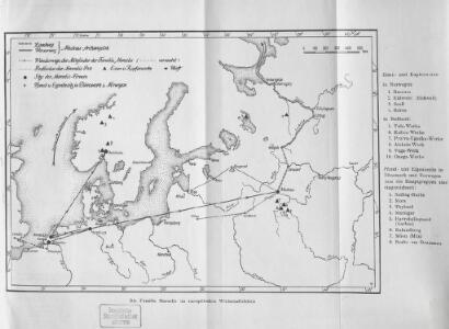
Die Familie Marselis im europäischen Wirtschaftsleben
Europa Marselis, Familie
A new map of Denmark and Sweden. ...
from The world described, or, A new and correct sett of maps : shewing the kingdoms and states in all the known parts of the earth, with the principal cities, and most considerable towns in the world ... / ... by Herman Moll, geographer ...
Carte generale de toute l'Europe, 2
2 Blätter : 56 x 90 cm J.M. Will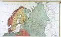
Carte générale de toute l'Europe, 3
2 Blätter : 58 x 94 cm T.C. Lotter
Scandinavien und Polen, kirchlichen Eintheilung bis zur Reformation.
1 : 9400000 Spruner von Merz, Karl
Russie, Pologne, Suede, Norwege, Danemarck en 1840.
1 : 11600000 Houze, Antoine Philippe
Russie, Suede, Norwege, Danemarck a la fin du Ve. siecle.
1 : 11600000 Houze, Antoine Philippe
Russie, Suede, Norwege, Danemarck a la fin du IXe. siecle.
1 : 11600000 Houze, Antoine Philippe
MOSCOVIAE seu RUSSIAE MAGNAE Generalis Tabula
1 : 10500000 Dánsko Seutter, Matthäus per Matth. Seutter
Carte générale de la Russie européenne / Tardieu sculp. ; André scrip
1 : 9000000 1 Karte : Kupferdruck ; 31 x 42 cm Mentelle, Edme [Mentelle]
Nord- und Ost-Europa im Anfange des XIVten Jahrhunderts
1 : 14000000 Nordeuropa, Osteuropa
Rvssia cum confinijs
1 Karte : Kupferdruck ; 34 x 46 cm Mercator; Hondius Henricus Hondius
Russia cum confinijs / per Gerardum Mercatorem
1 : 9700000 1 Karte : Kupferdruck ; 34 x 46 cm Mercator, Gerhard [Jodocus Hondius]
Russia cum confiniis
1 : 23100000 1 Karte : Kupferdruck ; 13 x 18 cm Mercator, Gerhard [Verlag nicht ermittelbar]
Russia cum confiniis
1 : 20000000 1 Karte : Kupferdruck ; 13 x 18 cm Mercator, Gerhard printed by William Stansby for Henrie Fetherstone
Russia cum confinijs / per Gerardum Mercatorem
1 : 9700000 1 Karte : Kupferdruck ; 34 x 46 cm Mercator, Gerhard [Jodocus Hondius]
Tabvla Rvssiæ / ex autographo, quod delineandum curavit Foedor filius tzaris Boris desumta; et ad f
1 : 9000000 1 Karte : Kupferdruck ; 41 x 53 cm Fëdor excusum apud Guiljelmum Blaeu
Tabula Russiae ex autographo, quod delineandum curavit Foedor filius Tzaris Bori et ad fluvios Dwina
1 : 1100000 1 Karte : Kupferdruck ; 27 x 34 cm [Matthäus Merian d. Ältere]
Russie, Pologne, Suede, Norwege, Danemarck , fin du XIVe. siecle.
1 : 11600000 Houze, Antoine Philippe
Ethnographische Übersichtskarte von Osteuropa
1 : 10000000 Russland Ukraine Ethnische Gruppe Kartogr. Anstalt G. Freytag & Berndt, Ges. m. b. H., Wien
La Russie.
1 : 8400000 Clouet, J. B. L. (Jean-Baptiste Louis), b. 1730
Der Westhandel Nordosteuropas in der Frühen Neuzeit
Europa (Nordost) Handel
Finnland und Skandinavien
1 : 4000000 Finsko Velhagen & Klasing
Octava Europe Tabula. [Sarmatia Europe] [Karte], in: Claudii Ptolemei viri Alexandrini mathematice discipline philosophi doctissimi geographie opus [...], S. 172.
1 Karte aus Atlas Waldseemüller, Martin [und Ptolemaeus, Claudius] Übelin, Georg
Die Hauptzüge der in der Geschichte der Völkerwanderung erscheinenden Völker
Evropa Gatti, Ferdinand J.F. Kaiser
La Russie européenne / par Mr. Brion, Ingénieur Géographe du Roi
1 : 11000000 1 Karte : Kupferdruck ; 22 x 25 cm Brion de la Tour, Louis chez le Sr Desnos
Russia in Europe.
1 : 11000000 Darton, William
Russia or Moscovy in Europe / T. Kitchin sculp.
1 : 19500000 1 Karte : Kupferdruck ; 18 x 22 cm Kitchin, Thomas [Verlag nicht ermittelbar]
Carte Pour l'Intelligence des Affaires Presente
1 : 7300000 Mollova mapová sbírka Fer, Nicolas de Fer, Nicolas de