Maps of Bulgaria

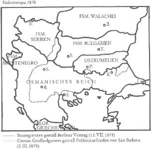
Südosteuropa 1878
Südosteuropa Berliner Kongress
Nr. 18. Die Eroberung Serbiens
Serbien Weltkrieg <1914-1918>, Eroberung
Die Euopaeische Türkei von der Gränze Griechenlands bis zu den Mündungen der Donau
Hand-Atlas über alle Theile der Erde nach dem neuesten Zustande und über das Weltgebäude Stieler, Adolf bei Justus Perthes
Südosteuropa 1919-1941/44
Südosteuropa Grenzen

[Die Europäische Türkei]
Hand-Atlas über alle Theile der Erde nach dem neuesten Zustande und über das Weltgebäude Stieler, Adolf bei Justus Perthes
Das Erste Bulgarische Reich (680-1018 n. Chr.)
Bulgarien
Das Zweite Bulgarische Reich (1087-1256 n. Chr.)
Bulgarien
Règions occupèes par les belligèrants fin avril 1913
Südosteuropa Balkankrieg <1912-1913> Besetzte Gebiete
Die europaeische Türkei von der Gränze Griechenlands bis zu den Mündungen der Donau
1 : 2500000 Evropa jihovýchodní Stülpnagel, Friedrich von Justus Perthes
Die europaeische Türkei von der Gränze Griechenlands bis zu den Mündungen der Donau
osmanská říše Stülpnagel, Friedrich von Hanemann, August Justus Perthes
Die europaeische Türkei von der Gränze Griechenlands bis zu den Mündungen der Donau
osmanská říše Stülpnagel, Friedrich von Hanemann, August Justus Perthes
Reich des Stephan Duschan
1 : 10000000 Serbien Stefan Dušan, Srbija, Car
G. Freytag's Karte der Balkan-Halbinsel
1 : 1250000 Balkánský poloostrov G. Freytag & Berndt
Grenzen vor dem Kriege
Südosteuropa Osmanisches Reich Grenze
Grenzen Herbst 1913
Südosteuropa Osmanisches Reich Grenze Balkankrieg <1912-1913>
Balkan
Balkanhalbinsel
Die Europäische Türkei
Handatlas über alle Theile der Erde und über das Weltgebäude Stieler, Adolf Justus Perthes
Mapa Balkánu
Die von den Balkanstaaten bis Ende April 1913 besetzten Gebiete
Südosteuropa, Osmanisches Reich, Balkankriege Häusler, Ines
G. Freytags Karte des Kriegsschauplatzes auf der Balkanhalbinsel
Balkanhalbinsel Osmanisches Reich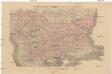
Černá Hora, Srbsko a Bulharsko dle ustanovení míru Sv.-Štěpánského
Černá Hora Fáborský, Jan B. Nipočić, Vasilij Bohuslav Pichl
Europäische Türkey
Grosser Hand-Atlas über alle Theile der Erde in 170 Karten Meyer, J. Verlag des Bibliographischen Instituts
Carte de la Turquie d'Europe
Balkánský poloostrov Boué, A. Arthus-Bertrand chez Arthus-Bertrand
Gegenwärtig Stand der neuen politischen Grenzen auf der Balkan-Halbinsel
1 : 1600000 Balkánský poloostrov Rothaug, Johann Georg G. Freytag & Berndt
Europae tabula IX
1 : 5600000 1 Karte : Kupferdruck ; 19 x 25 cm Ptolemaeus, Claudius [Vincenzo Valgrisi]
Carte de la Turquie d'Europe
Balkánský poloostrov Boué, A. Avril, Ch. chez Arthus-Bertrand
Die Europäische Türkei
Hand-Atlas über alle Theile der Erde und über das Weltgebäude Stieler, Adolf Justus Perthes
Die Europaische Turkei.
1 : 2500000 Petermann, A.