Maps of Balkan Pen.

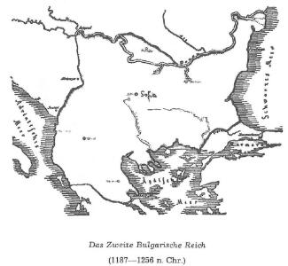
Das Zweite Bulgarische Reich (1087-1256 n. Chr.)
Bulgarien
Die von den Balkanstaaten bis Ende April 1913 besetzten Gebiete
Südosteuropa, Osmanisches Reich, Balkankriege Häusler, Ines
Carte de la Turquie d'Europe
Balkánský poloostrov Boué, A. Arthus-Bertrand chez Arthus-Bertrand
Carte de la Turquie d'Europe
Balkánský poloostrov Boué, A. Avril, Ch. chez Arthus-Bertrand
Reich des Stephan Duschan
1 : 10000000 Serbien Stefan Dušan, Srbija, Car
Turkey in Europe.
1 : 3000000 Colton, G.W.
Das Erste Bulgarische Reich (680-1018 n. Chr.)
Bulgarien
Die Europäische Türkei
Handatlas über alle Theile der Erde und über das Weltgebäude Stieler, Adolf Justus Perthes
Grenzen Herbst 1913
Südosteuropa Osmanisches Reich Grenze Balkankrieg <1912-1913>
Règions occupèes par les belligèrants fin avril 1913
Südosteuropa Balkankrieg <1912-1913> Besetzte Gebiete
Die Europaische Turkei.
1 : 2500000 Petermann, A.
Grenzen vor dem Kriege
Südosteuropa Osmanisches Reich Grenze
Colton's Turkey in Europe.
1 : 1600000 Colton, G.W.
Europ. Turkey.
1 : 3100000 Radefeld, Carl Christian Franz, 1788-1874
Graecia nova et mare Aegeum s. Archipelagus, in qua mappa Macedonia, Albania, Epirus, Thessalia et Morea, cum circumjacentibus insulis Corcyra, Cephalonia, Zacynthos, Stalimene, Metelino, Chios, distinctae exhibentur
1 : 1660000 Achaia (Řecko) Lotter, Tobias Conrad sumtibus Tobiae Conradi Lotteri
Graecia nova et mare Aegeum s. Archipelagus, in qua mappa Macedonia, Albania, Epirus, Thessalia et Morea cum circumjacentibus insulis Corcyra, Cephalonia, Zacynthos, Stalimene, Metelino, Chios, distinctae exhibentur
1 : 1660000 Achaia (Řecko) Lotter, Tobias Conrad sumtibus Tobiae Conradi Lotteri
Ethnographische Karte der europäischen Türkei und ihrer Dependenzen zu Anfang des Jahres 1877
Südosteuropa Ethnische Gruppe Sax, Carl
Europäische Türkey
Grosser Hand-Atlas über alle Theile der Erde in 170 Karten Meyer, J. Verlag des Bibliographischen Instituts
Balkan
Balkanhalbinsel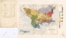
Ethnographische Karte von Europäischen Türkei...

Types des villages
1 : 6000000 Balkanhalbinsel Südosteuropa Ländliche Siedlung
Formes de la propriété rurale
1 : 6000000 Balkanhalbinsel Südosteuropa Grundeigentum
Types des maisons
1 : 6000000 Balkanhalbinsel Südosteuropa Haus
Northern Turkey in Europe, with part of Hungary and Dalmatia
1 : 3000000 Arrowsmith, Aaron Jr.
Balkanhalbinsel
1 : 5000000 Balkánský poloostrov F. A. Brouckaus' Geogr.-artist. Anstalt
Carte ethnographique de la Turquie d'Europe
Dunaj (Rumunsko a Ukrajina : řeka : delta) Lejean, G. Petermann, August Justus Perthes
Turkey
1 : 12330000 Turecko Walker, C. Baldwin & Cradock
Die Euopaeische Türkei von der Gränze Griechenlands bis zu den Mündungen der Donau
Hand-Atlas über alle Theile der Erde nach dem neuesten Zustande und über das Weltgebäude Stieler, Adolf bei Justus Perthes
Die Europäische Türkei
Hand-Atlas über alle Theile der Erde und über das Weltgebäude Stieler, Adolf Justus Perthes